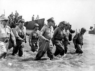
The Battle of Leyte in the Pacific campaign of World War II was the amphibious invasion of the island of Leyte in the Philippines by American forces and Filipino guerrillas under the overall command of General Douglas MacArthur, who fought against the Imperial Japanese Army in the Philippines led by General Tomoyuki Yamashita. The operation, codenamed King Two, launched the Philippines campaign of 1944–45 for the recapture and liberation of the entire Philippine Archipelago and to end almost three years of Japanese occupation.

Leyte, officially the Province of Leyte, is a province in the Philippines located in the Eastern Visayas region occupying the northern three-quarters of Leyte Island. Its capital and largest city is Tacloban, administered independently from the province. Leyte is thus north of Southern Leyte, south of Biliran, and west of Samar Island. To the west across the Camotes Sea is the province of Cebu.

Ormoc, officially the City of Ormoc, is a 1st class independent component city in the Eastern Visayas region of the Philippines. According to the 2020 census, it has a population of 230,998 inhabitants, making it the second most-populous city in the province of Leyte after the provincial capital of Tacloban. Ormoc is the economic, cultural, commercial and transportation hub of western Leyte.

Abuyog, officially the Municipality of Abuyog, is a municipality in the province of Leyte, Philippines. According to the 2020 census, it has a population of 61,216 people.

Maasin, officially the City of Maasin, is a 4th class component city and capital of the province of Southern Leyte, Philippines. According to the 2020 census, it has a population of 87,446 people.

San Ricardo, officially the Municipality of San Ricardo, is a 5th class municipality in the province of Southern Leyte, Philippines. According to the 2020 census, it has a population of 10,500 people.

Baybay, officially the City of Baybay, is a 1st class component city in the province of Leyte, Philippines. It has a population of 111,848 people.

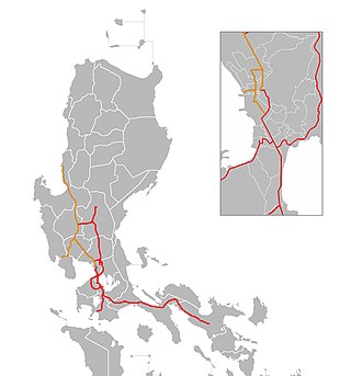
The Pan-Philippine Highway, also known as the Maharlika Highway, is a network of roads, expressways, bridges, and ferry services that connect the islands of Luzon, Samar, Leyte, and Mindanao in the Philippines, serving as the country's principal transport backbone. Measuring 3,379.73 kilometers (2,100.07 mi) long excluding sea routes not counted by highway milestones, it is the longest road in the Philippines that forms the country's north–south backbone component of National Route 1 (N1) of the Philippine highway network. The entire highway is designated as Asian Highway 26 (AH26) of the Asian Highway Network.
The legislative districts of Leyte are the representations of the province of Leyte, the independent component city of Ormoc, and highly urbanized city of Tacloban in the various national legislatures of the Philippines. The province, together with the independent cities are currently represented in the lower house of the Congress of the Philippines through their first, second, third, fourth, and fifth congressional districts.

The MacArthur Highway, officially the Manila North Road, is a 684.855-kilometer (425.549 mi), two-to-six lane, national primary highway and tertiary highway in Luzon, Philippines, connecting Caloocan in Metro Manila to Aparri in Cagayan at the north. It is the second longest road in the Philippines, after Pan-Philippine Highway. It is primarily known as MacArthur Highway in segments from Caloocan to Urdaneta, Pangasinan, although it is also applied up to Ilocos Sur, and likewise called as Manila North Road for the entire length.
Eastern Visayas is an administrative region in the Philippines, designated as Region VIII. It consists of three main islands: Samar, Leyte, and Biliran. The region has six provinces: Biliran, Leyte, Northern Samar, Samar, Eastern Samar, Southern Leyte, one independent city, Ormoc, and one highly urbanized city, Tacloban. The highly urbanized city of Tacloban is the sole regional center. These provinces and cities occupy the easternmost islands of the Visayas group of islands, hence the region's name.
The Philippine highway network is a network of national roads owned and maintained by the Department of Public Works and Highways (DPWH) and organized into three classifications according to their function or purpose: national primary, secondary, and tertiary roads. The national roads connecting major cities are numbered from N1 to N83. They are mostly single and dual carriageways linking two or more cities.
On July 6, 2017, a 6.5 magnitude earthquake hit Leyte, causing at least 4 deaths and 100 injuries. The quake also caused power interruptions in the whole of Eastern Visayas and nearby Bohol.

National Route 1 (N1) is a primary national route that forms part of the Philippine highway network, running from Luzon to Mindanao. Except for a 19-kilometer (12 mi) gap in Metro Manila and ferry connections, the highway is generally continuous. Most sections of N1 forms the Pan-Philippine Highway except for sections bypassed by expressways.
Expressway 1 (E1) forms part of the Philippine expressway network. It runs through western Luzon from Quezon City in the south to Rosario in the north.

Jose P. Laurel Highway is a 49-kilometer (30 mi), two-to-six lane, major highway running within the province of Batangas. The highway forms part of National Route 4 (N4) of the Philippine highway network. It is also known as Santo Tomas Bypass Road in Santo Tomas, Manila–Batangas Road from its junction with General Malvar Street in Santo Tomas southwards, and Ayala Highway in Lipa.

The Davao–Cotabato Road is a 205.7-kilometer (127.8 mi), two-to-six lane major national primary road, connecting the provinces of Davao del Sur, Maguindanao del Sur, Cotabato, and Maguindanao del Norte. It runs from Davao City to Sultan Kudarat, Maguindanao del Norte.
National Route 10 (N10) is a 278-kilometer (173 mi) primary national route that forms part of the Philippine highway network and a spur of Asian Highway 26(AH26) of the Asian Highway Network. It connects the provinces of Misamis Oriental, Bukidnon and Davao del Sur.
Cagayan Valley Road is a 121.216-kilometer (75.320 mi) major highway that connects the cities and municipalities of the province of Cagayan, Philippines.
Expressway 2 (E2) forms part of the Philippine expressway network. Its main route runs from Makati to Santo Tomas as South Luzon Expressway and from Santo Tomas to Batangas City as STAR Tollway. It also has spurs signed as E2 as well. South Luzon Expressway's section from Makati to Calamba, apparently as well as Skyway from Makati to Muntinlupa, is also part of AH26.

