
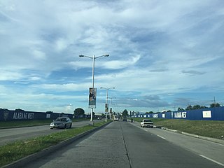
Roxas Boulevard is a popular waterfront promenade in Metro Manila in the Philippines. The boulevard, which runs along the shores of Manila Bay, is well known for its sunsets and stretch of coconut trees. The divided roadway has become a trademark of Philippine tourism, famed for its yacht club, hotels, restaurants, commercial buildings and parks.

The Juanito R. Remulla Sr. Road, formerly and still commonly referred to as Governor's Drive, is a two-to-nine lane, 58.3-kilometer (36.2 mi) network of primary, secondary and tertiary highways and bridges traversing through the central cities and municipalities of the province of Cavite, Philippines. It is the widest among the three major highways located in the province, the others being the Aguinaldo and Antero Soriano Highways.
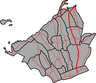
The Emilio Aguinaldo Highway,, alternatively known as Cavite–Batangas Road and Cavite-Manila South Road, is a four-to-six lane, 41.4-kilometer (25.7 mi), network of primary and secondary highways passing through the busiest towns and cities of Cavite, Philippines. It is the busiest and most congested of the three major highways located in the province, the others are Governor's Drive and Antero Soriano Highway.

The Antero Soriano Highway, also partly known as Centennial Road, is a two-to-six lane, 21.6-kilometer (13.4 mi) highway traversing through the western coast of Cavite. It is one of the three major highways located in the province, the others are Aguinaldo Highway and Governor's Drive.
Daang Hari, also known as the Las Piñas–Muntinlupa–Laguna–Cavite Link Road, is a collector road that links southern Metro Manila to the province of Cavite in the Philippines. It begins as a north–south road from Commerce Avenue, just south of the Alabang–Zapote Road running for 5.9 kilometers (3.7 mi) on the boundary of Las Piñas and Muntinlupa. It then runs east–west for about 9.2 kilometers (5.7 mi) from its junction with Daang Reyna, winding through the cities of Bacoor, Imus, Dasmariñas, and General Trias.
The Philippine highway network is a network of national roads owned and maintained by the Department of Public Works and Highways (DPWH) and organized into three classifications according to their function or purpose: national primary, secondary, and tertiary roads. The national roads connecting major cities are numbered from N1 to N83. They are mostly single and dual carriageways linking two or more cities.
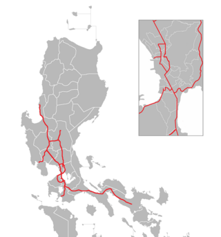
The Philippine expressway network, also known as the High Standard Highway Network, is a controlled-access highway network managed by the Department of Public Works and Highways (DPWH) which consists of all expressways and regional high standard highways in the Philippines.

The Santa Rosa–Tagaytay Road, also known as the Tagaytay–Santa Rosa Road and the Santa Rosa–Ulat–Tagaytay Road, is a 23.245-kilometer (14.444 mi) major thoroughfare in the provinces of Laguna and Cavite, Philippines. Originally an old road linking the Santa Rosa municipal proper to the western edge of the then-municipality at barangay Santo Domingo and narrowly onto barangay Lumil in Silang, the highway was constructed in the late 1990s.

National Route 231 (N231) forms a part of the Philippine highway network. It is a secondary road that runs through southern Benguet, from the City of Baguio to Itogon.

National Route 64 (N64) forms part of the Philippine highway network. It runs through northern Cavite.

National Route 402 (N402) forms part of the Philippine highway network. It runs through the rural municipalities of Cavite.
National Route 622 (N622) forms part of the Philippine highway network. It is one of the national secondary roads with two non-contiguous sections, one which runs through the municipalities of Kawit and Noveleta in Cavite, while the other road runs through the municipality of Daet in Camarines Norte; both of these roads are located in Luzon island.
National Route 62 (N62) forms part of the Philippine highway network. It runs south from Metro Manila to northeastern Cavite.
National Route 405 (N405) forms part of the Philippine highway network. It runs through western Cavite. It connects the municipality of Naic to Caylabne Bay.

National Route 65 (N65) forms part of the Philippine highway network. It runs through central Cavite and northern Laguna.
National Route 410 (N410) forms part of the Philippine highway network. It runs from southern Cavite to Batangas.
National Route 673 (N673) forms a part of the Philippine highway network. It is one of the national secondary roads with two non-contiguous highways, one which runs through the municipality of Pili, Camarines Sur in the Bicol region of Luzon, while the other road runs within the city of Calbayog in the Samar region of Visayas.
The Diokno Highway, also known as Payapa Road and formerly as Tagaytay-Junction–Calaca-Lemery Road, is a 20.064-kilometer (12.467 mi), two-lane, secondary road in Batangas that connects the city of Calaca, near its border with Nasugbu and Alfonso, Cavite, and the municipality of Lemery. It connects southern Cavite and Batangas.
National Route 401 (N401) forms part of the Philippine highway network. It connects the municipalities of Noveleta to the city of General Trias through the municipality of Rosario.
National Route 180 (N180) is a secondary national route that forms part of the Philippine highway network, running from Cubao, Quezon City to Ermita, Manila.

