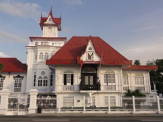
Cavite, officially the Province of Cavite, is a province in the Philippines located in the Calabarzon region in Luzon. Located on the southern shores of Manila Bay and southwest of Manila, it is one of the most industrialized and fastest-growing provinces in the Philippines. As of 2020, it has a population of 4,344,829, making it the most populated province in the country if the independent cities of Cebu are excluded from Cebu's population figure.

Bacoor, officially the City of Bacoor, is a 1st class component city in the province of Cavite, Philippines. According to the 2020 census, it has a population of 664,625 people, making it the 15th most populous city in the Philippines and the second largest city in the province of Cavite after Dasmariñas.

Imus, officially the City of Imus, is a 3rd class component city and de jure capital of the province of Cavite, Philippines. According to the 2020 census, it has a population of 496,794 people.
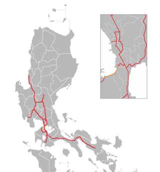
The Manila–Cavite Expressway, signed as E3 of the Philippine expressway network and R-1 of Metro Manila's arterial road network, is a 14-kilometer-long (8.7 mi) controlled-access toll expressway linking Manila to the southern province of Cavite in the Philippines. At its north end, it feeds into and from Roxas Boulevard in the city of Parañaque in Metro Manila, also part of R-1. At the south end, it splits into two termini, both along the north coast in Kawit, Cavite. The first feeds into the intersection of Tirona Highway and Antero Soriano Highway. The second southern terminus is on the intersection of Tirona Highway, Antero Soriano Highway and Covelandia Road in Kawit, Cavite.

The Tejeros Convention, also known as the Tejeros Assembly and the Tejeros Congress, was a meeting held on March 22, 1897, between Katipunan factions of Magdiwang and Magdalo in San Francisco de Malabon, Cavite that resulted in the creation of a new revolutionary government that took charge of the Philippine Revolution, replacing the Katipunan. It followed on a previous meeting now known as the Imus Assembly. Filipino historians consider the first presidential and vice presidential elections in Philippine history to have been held at this convention, although only Katipuneros were able to take part, and not the general populace.

The Magdalo was a faction of the Katipunan chapter in Cavite.
Daniel Tirona y Tria was a Filipino politician. He became infamous for causing divisions within the Philippine revolutionary movement and for insulting and maligning Andres Bonifacio during the Tejeros Convention in 1897.

The Juanito R. Remulla Sr. Road, formerly and still commonly referred to as Governor's Drive, is a two-to-nine lane, 58.3-kilometer (36.2 mi) network of primary, secondary and tertiary highways and bridges traversing through the central cities and municipalities of the province of Cavite, Philippines. It is the widest among the three major highways located in the province, the others being the Aguinaldo and Antero Soriano Highways.
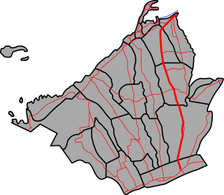
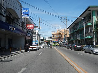
The Emilio Aguinaldo Highway,, alternatively known as Cavite–Batangas Road and Cavite-Manila South Road, is a four-to-six lane, 41.4-kilometer (25.7 mi), network of primary and secondary highways passing through the busiest towns and cities of Cavite, Philippines. It is the busiest and most congested of the three major highways located in the province, the others are Governor's Drive and Antero Soriano Highway.

The Antero Soriano Highway, also partly known as Centennial Road, is a two-to-six lane, 21.6-kilometer (13.4 mi) highway traversing through the western coast of Cavite. It is one of the three major highways located in the province, the others are Aguinaldo Highway and Governor's Drive.

The Cavite–Laguna Expressway, signed as E3 of the Philippine expressway network, is a partially operational controlled-access toll expressway in the provinces of Cavite and Laguna, Philippines. The construction of the 44.63-kilometer-long (27.73 mi) expressway, which began in July 2019, costs an estimated ₱35.43 billion. Once completed, it will connect the Manila–Cavite Expressway in Kawit to the South Luzon Expressway in Biñan and is expected to ease the traffic congestion in the Cavite–Laguna area, particularly along the Aguinaldo Highway, Governor's Drive, and the Santa Rosa–Tagaytay Road.

El Presidente: General Emilio Aguinaldo Story and the First Philippine Republic, or simply El Presidente, is a 2012 biographical film written and directed by Mark Meily about the life of General Emilio Aguinaldo, the first president of the Philippine Republic. The film stars Jeorge "E.R." Ejercito Estregan in the title role, along with Nora Aunor, Christopher de Leon, Cristine Reyes, and Cesar Montano.
Daang Hari, also known as the Las Piñas–Muntinlupa–Laguna–Cavite Link Road, is a collector road that links southern Metro Manila to the province of Cavite in the Philippines. It begins as a north–south road from Commerce Avenue, just south of the Alabang–Zapote Road running for 5.9 kilometers (3.7 mi) on the boundary of Las Piñas and Muntinlupa. It then runs east–west for about 9.2 kilometers (5.7 mi) from its junction with Daang Reyna, winding through the cities of Bacoor, Imus, Dasmariñas, and General Trias.
Elpidio Quirino Avenue, also known simply as Quirino Avenue, is a major north-south collector road in Parañaque, southern Metro Manila, Philippines. It is a four-lane undivided arterial running parallel to Roxas Boulevard and its extension, the Manila–Cavite Expressway, to the west from Baclaran at Parañaque's border with Pasay in the north to San Dionisio right by the border with Las Piñas in the south. It is a continuation of Harrison Avenue from Pasay and was originally a segment of the coastal highway called Calle Real. The entire road is a component of Radial Road 2 (R-2) of Manila's arterial road network, while its segment south of NAIA Road is a component of National Route 62 (N62) of the Philippine highway network. It was named after President Elpidio Quirino. The road's name is also applied alternatively to Diego Cera Avenue in Las Piñas.
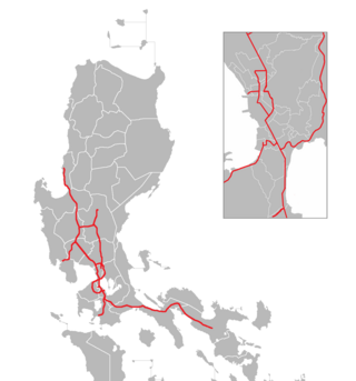
The Philippine expressway network, also known as the High Standard Highway Network, is a controlled-access highway network managed by the Department of Public Works and Highways (DPWH) which consists of all expressways and regional high standard highways in the Philippines.

The Tagaytay–Nasugbu Highway, alternatively known as Tagaytay–Nasugbu Road and formerly as Tagaytay–Tuy–Nasugbu Port Road, is a 43.86-kilometer (27.25 mi), two-to-four lane, secondary highway in the provinces of Cavite and Batangas, Philippines, that connects the city of Tagaytay in Cavite and the municipality of Nasugbu in Batangas.
National Route 62 (N62) forms part of the Philippine highway network. It runs south from Metro Manila to northeastern Cavite.

National Route 65 (N65) forms part of the Philippine highway network. It runs through central Cavite and northern Laguna.
National Route 410 (N410) forms part of the Philippine highway network. It runs in southern Cavite to Batangas.
The Tagaytay–Calamba Road is a two- to four-lane, secondary and tertiary road in Laguna and Cavite, Philippines. Albeit discontinuous, it connects the city of Calamba in Laguna and the city of Tagaytay in Cavite. The road's missing link that will connect its Tagaytay and Calamba sections is under construction.


