Cavite, officially the Province of Cavite, is a province in the Philippines located in the Calabarzon region in Luzon. Located on the southern shores of Manila Bay and southwest of Manila, it is one of the most industrialized and fastest-growing provinces in the Philippines. As of 2020, it has a population of 4,344,829, making it the most populated province in the country if the independent cities of Cebu are excluded from Cebu's population figure.

General Trias, officially the City of General Trias, is a 1st class component city in the province of Cavite, Philippines. According to the 2020 census, it has a population of 450,583 people.

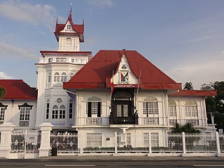
Trece Martires, officially the City of Trece Martires, is a 4th class component city and de facto capital city of the province of Cavite, Philippines. According to the 2020 census, it has a population of 210,503 people.
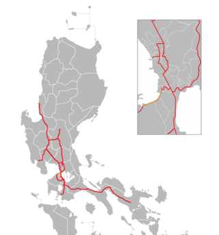
The Manila–Cavite Expressway, signed as E3 of the Philippine expressway network and R-1 of Metro Manila's arterial road network, is a 14-kilometer-long (8.7 mi) controlled-access toll expressway linking Manila to the southern province of Cavite in the Philippines. At its north end, it feeds into and from Roxas Boulevard in the city of Parañaque in Metro Manila, also part of R-1. At the south end, it splits into two termini, both along the north coast in Kawit, Cavite. The first feeds into the intersection of Tirona Highway and Antero Soriano Highway. The second southern terminus is on the intersection of Tirona Highway, Antero Soriano Highway and Covelandia Road in Kawit, Cavite.

Radial Road 1 (R-1), informally known as the R-1 Road, is a network of roads and bridges that all together form the first arterial road of Metro Manila in the Philippines. Spanning some 41.5 kilometers (25.8 mi), it connects the cities and municipalities of Bacoor, General Trias, Imus, Kawit, Las Piñas, Manila, Naic, Noveleta, Parañaque, Pasay, and Tanza in Cavite and Metro Manila.

The Juanito R. Remulla Sr. Road, formerly and still commonly referred to as Governor's Drive, is a two-to-nine lane, 58.3-kilometer (36.2 mi) network of primary, secondary and tertiary highways and bridges traversing through the central cities and municipalities of the province of Cavite, Philippines. It is the widest among the three major highways located in the province, the others being the Aguinaldo and Antero Soriano Highways.

The Antero Soriano Highway, also partly known as Centennial Road, is a two-to-six lane, 21.6-kilometer (13.4 mi) highway traversing through the western coast of Cavite. It is one of the three major highways located in the province, the others are Aguinaldo Highway and Governor's Drive.
Local elections were held in the province of Cavite on May 13, 2013 within the Philippine general election. Voters selected candidates for all local positions: a mayor, vice mayor, councilors, members of the Sangguniang Panlalawigan, the vice-governor, governor and representatives for the seven districts of Cavite.

Tramo Street is a major local road in Pasay, Metro Manila, Philippines. It runs north-south from Ocampo Street in the border with Malate, Manila to Andrews Avenue in Maricaban. It is interrupted by Epifanio de los Santos Avenue (EDSA) and the MRT Line 3 line which divides the road into two sections, the southern section running from EDSA to Andrews Avenue having been renamed to Aurora Boulevard.
Daang Hari, also known as the Las Piñas–Muntinlupa–Laguna–Cavite Link Road, is a collector road that links southern Metro Manila to the province of Cavite in the Philippines. It begins as a north–south road from Commerce Avenue, just south of the Alabang–Zapote Road running for 5.9 kilometers (3.7 mi) on the boundary of Las Piñas and Muntinlupa. It then runs east–west for about 9.2 kilometers (5.7 mi) from its junction with Daang Reyna, winding through the cities of Bacoor, Imus, Dasmariñas, and General Trias.

Circumferential Road 6 (C-6), informally known as the C-6 Road, is a network of roads and bridges that all together will form the sixth and outermost beltway of Metro Manila in the Philippines once it is completed.

The Tanza–Trece Martires Road is a 12.559-kilometer (7.804 mi), two-to-four lane, primary highway in Cavite, Philippines. It connects the municipality of Tanza to the city of Trece Martires.

The Trece Martires–Indang Road is a two-to-four lane 12.015-kilometer (7.466 mi) secondary highway in Cavite, Philippines.

National Route 402 (N402) forms part of the Philippine highway network. It runs through the rural municipalities of Cavite.
National Route 622 (N622) forms part of the Philippine highway network. It is one of the national secondary roads with two non-contiguous sections, one which runs through the municipalities of Kawit and Noveleta in Cavite, while the other road runs through the municipality of Daet in Camarines Norte; both of these roads are located in Luzon island.
National Route 62 (N62) forms part of the Philippine highway network. It runs south from Metro Manila to northeastern Cavite.
National Route 403 (N403) forms part of the Philippine highway network. It runs through central Cavite. It connects the city of Trece Martires to the municipality of Naic.

National Route 65 (N65) forms part of the Philippine highway network. It runs through central Cavite and northern Laguna.
National Route 401 (N401) forms part of the Philippine highway network. It connects the municipalities of Noveleta to the city of General Trias through the municipality of Rosario.

The Cavite Provincial Board is the Sangguniang Panlalawigan of the Philippine province of Cavite.

