
Daet, officially the Municipality of Daet, is a 1st class municipality and capital of the province of Camarines Norte, Philippines. According to the 2020 census, it has a population of 111,700 people.
The Manila–Cavite Expressway, signed as E3 of the Philippine expressway network and R-1 of Metro Manila's arterial road network, is a 14-kilometer-long (8.7 mi) controlled-access toll expressway linking Manila to the southern province of Cavite in the Philippines. At its north end, it feeds into and from Roxas Boulevard in the city of Parañaque in Metro Manila, also part of R-1. At the south end, it splits into two termini, both along the north coast in Kawit, Cavite. The first feeds into the intersection of Tirona Highway and Antero Soriano Highway. The second southern terminus is on the intersection of Tirona Highway, Antero Soriano Highway and Covelandia Road in Kawit, Cavite.

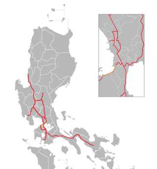
The Pan-Philippine Highway, also known as the Maharlika Highway, is a network of roads, expressways, bridges, and ferry services that connect the islands of Luzon, Samar, Leyte, and Mindanao in the Philippines, serving as the country's principal transport backbone. Measuring 3,379.73 kilometers (2,100.07 mi) long excluding sea routes not counted by highway milestones, it is the longest highway in the Philippines that forms the country's north–south backbone component of National Route 1 (N1) of the Philippine highway network. The entire highway is designated as Asian Highway 26 (AH26) of the Asian Highway Network.

The Juanito R. Remulla Sr. Road, formerly and still commonly referred to as Governor's Drive, is a two-to-nine lane, 58.3-kilometer (36.2 mi) network of primary, secondary and tertiary highways and bridges traversing through the central cities and municipalities of the province of Cavite, Philippines. It is the widest among the three major highways located in the province, the others being the Aguinaldo and Antero Soriano Highways.
The Emilio Aguinaldo Highway,, alternatively known as Cavite–Batangas Road and Cavite-Manila South Road, is a four-to-six lane, 41.4-kilometer (25.7 mi), network of primary and secondary highways passing through the busiest towns and cities of Cavite, Philippines. It is the busiest and most congested of the three major highways located in the province, the others are Governor's Drive and Antero Soriano Highway.

The Antero Soriano Highway, also partly known as Centennial Road, is a two-to-six lane, 21.6-kilometer (13.4 mi) highway traversing through the western coast of Cavite. It is one of the three major highways located in the province, the others are Aguinaldo Highway and Governor's Drive.
Daang Hari, also known as the Las Piñas–Muntinlupa–Laguna–Cavite Link Road, is a collector road that links southern Metro Manila to the province of Cavite in the Philippines. It begins as a north–south road from Commerce Avenue, just south of the Alabang–Zapote Road running for 5.9 kilometers (3.7 mi) on the boundary of Las Piñas and Muntinlupa. It then runs east–west for about 9.2 kilometers (5.7 mi) from its junction with Daang Reyna, winding through the cities of Bacoor, Imus, Dasmariñas, and General Trias.

Circumferential Road 6 (C-6), informally known as the C-6 Road, is a network of roads and bridges that all together will form the sixth and outermost beltway of Metro Manila in the Philippines once it is completed.

The Santa Rosa–Tagaytay Road, also known as the Tagaytay–Santa Rosa Road and the Santa Rosa–Ulat–Tagaytay Road, is a 23.245-kilometer (14.444 mi) major thoroughfare in the provinces of Laguna and Cavite, Philippines. Originally an old road linking the Santa Rosa municipal proper to the western edge of the then-municipality at barangay Santo Domingo and narrowly onto barangay Lumil in Silang, the highway was constructed in the late 1990s.
National Route 1 (N1) is a primary national route that forms part of the Philippine highway network, running from Luzon to Mindanao. Except for a 19-kilometer (12 mi) gap in Metro Manila and ferry connections, the highway is generally continuous. Most sections of N1 forms the Pan-Philippine Highway except for sections bypassed by expressways.

National Route 64 (N64) forms part of the Philippine highway network. It runs through northern Cavite.

National Route 402 (N402) forms part of the Philippine highway network. It runs through the rural municipalities of Cavite.
National Route 62 (N62) forms part of the Philippine highway network. It runs south from Metro Manila to northeastern Cavite.
National Route 651 (N651) forms a part of the Philippine highway network. It is one of the national secondary roads with two non-contiguous sections, one which runs through the municipality of Carmona, Cavite in the Calabarzon region , while the other road runs within the island of Catanduanes in the Bicol region.
National Route 673 (N673) forms a part of the Philippine highway network. It is one of the national secondary roads with two non-contiguous highways, one which runs through the municipality of Pili, Camarines Sur in the Bicol region of Luzon, while the other road runs within the city of Calbayog in the Samar region of Visayas.
National Route 5 (N5) forms part of the Philippine highway network. It runs through the province of Capiz to the province of Iloilo, both in the island of Panay.
National Route 401 (N401) forms part of the Philippine highway network. It connects the municipalities of Noveleta to the city of General Trias through the municipality of Rosario.

The Butuan–Cagayan de Oro–Iligan Road, or Butuan–Cagayan de Oro–Iligan–Tukuran Road, is a 416-kilometer (258 mi), two-to-six lane major thoroughfare, connecting the provinces of Agusan del Norte, Misamis Oriental, Lanao del Norte, and Zamboanga del Sur.
The Laoag Airport Road, also known as Airport Avenue, Airport Access Road, and Airport Road, is a national secondary road that connects the Manila North Road to Laoag International Airport.
