
Transportation in the Philippines covers the transportation methods within this archipelagic nation of over 7,500 islands. From a previously underdeveloped state of transportation, the government of the Philippines has been improving transportation through various direct infrastructure projects, and these include an increase in air, sea, road, and rail transportation and transport hubs.

The Pan-Philippine Highway, also known as the Maharlika Highway, is a network of roads, expressways, bridges, and ferry services that connect the islands of Luzon, Samar, Leyte, and Mindanao in the Philippines, serving as the country's principal transport backbone. Measuring 3,379.73 kilometers (2,100.07 mi) long excluding sea routes not counted by highway milestones, it is the longest road in the Philippines that forms the country's north–south backbone component of National Route 1 (N1) of the Philippine highway network. The entire highway is designated as Asian Highway 26 (AH26) of the Asian Highway Network.

Circumferential Road 5 (C-5), informally known as the C-5 Road, is a network of roads and bridges that all together form the fifth beltway of Metro Manila in the Philippines. Spanning some 43.87 kilometers (27.26 mi), it connects the cities of Las Piñas, Parañaque, Pasay, Pasig, Quezon City, Taguig, and Valenzuela.

The MacArthur Highway, officially the Manila North Road, is a 684.855-kilometer (425.549 mi), two-to-six lane, national primary highway and tertiary highway in Luzon, Philippines, connecting Caloocan in Metro Manila to Aparri in Cagayan at the north. It is the second longest road in the Philippines, after Pan-Philippine Highway. It is primarily known as MacArthur Highway in segments from Caloocan to Urdaneta, Pangasinan, although it is also applied up to Ilocos Sur, and likewise called as Manila North Road for the entire length.
The Emilio Aguinaldo Highway,, alternatively known as Cavite–Batangas Road and Cavite-Manila South Road, is a four-to-six lane, 41.4-kilometer (25.7 mi), network of primary and secondary highways passing through the busiest towns and cities of Cavite, Philippines. It is the busiest and most congested of the three major highways located in the province, the others are Governor's Drive and Antero Soriano Highway.

Dr. Arcadio Santos Avenue or Dr. Santos Avenue, formerly and still referred to as Sucat Road or Parañaque–Sucat Road, is the primary east–west thoroughfare in Parañaque, southern Metro Manila, Philippines. The avenue's western end is in Barangay San Dionisio as the continuation of Ninoy Aquino Avenue. Physically, Ninoy Aquino Avenue connects northbound to NAIA Road in Pasay which, in turn, continues west to Roxas Boulevard back in Parañaque, where it ends. Its eastern end is at the East Service Road, which runs parallel to South Luzon Expressway, in Barangay Sucat, Muntinlupa, where it becomes Meralco Road to service the rest of the route to Sucat railway station.

Alabang–Zapote Road is a four-lane national road which travels east–west through the southern limits of Metro Manila, Philippines. It runs parallel to Dr. Santos Avenue in the north and is named for the two barangays that it links: Alabang in Muntinlupa and Zapote in Las Piñas.
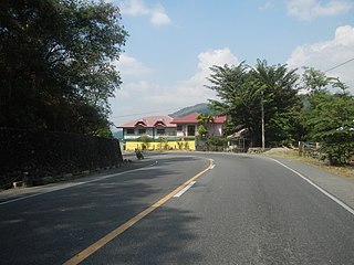
The Pugo–Rosario Road is a major road in La Union that connects from MacArthur Highway in Rosario to the Aspiras–Palispis Highway in Pugo. It is the alternative route to Marcos Highway for motorists going to Pugo and Baguio.

Dimasalang Street is a major road between the districts of Sampaloc and Santa Cruz in the Manila, the capital city of the Philippines. Running 1.9 kilometers (1.2 mi) in the north–south direction, it connects Lacson Avenue and Laon Laan Street in the south to Blumentritt Road, near the city's border with Quezon City, in the north. It also crosses over the Philippine National Railway tracks and below NLEX Connector at Dimasalang Bridge. It is named after Dimasalang, one of the pen names of the Philippine national hero José Rizal.
The Philippine highway network is a network of national roads owned and maintained by the Department of Public Works and Highways (DPWH) and organized into three classifications according to their function or purpose: national primary, secondary, and tertiary roads. The national roads connecting major cities are numbered from N1 to N83. They are mostly single and dual carriageways linking two or more cities.
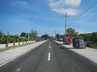
Sorsogon Diversion Road, officially known as Salvador H. Escudero III Diversion Road, is a 7.4-kilometer (4.6 mi), national secondary road in the city of Sorsogon of the Sorsogon province in the Philippines. Its official name, enacted in 2018, derives from Salvador Escudero III, who served as the province's 1st district representative and the country's agriculture secretary.

The Tanza–Trece Martires Road is a 12.559-kilometer (7.804 mi), two-to-four lane, primary highway in Cavite, Philippines. It connects the municipality of Tanza to the city of Trece Martires.

The Trece Martires–Indang Road is a two-to-four lane 12.015-kilometer (7.466 mi) secondary highway in Cavite, Philippines.

The Calamba–Pagsanjan Road, officially known as Calamba–Sta. Cruz–Famy Junction Road and National Highway, is a two-to-four lane primary highway located in the province of Laguna in the Philippines.
National Route 1 (N1) is a primary national route that forms part of the Philippine highway network, running from Luzon to Mindanao. Except for a 19-kilometer (12 mi) gap in Metro Manila and ferry connections, the highway is generally continuous. Most sections of N1 forms the Pan-Philippine Highway except for sections bypassed by expressways.

Jose P. Laurel Highway is a 49-kilometer (30 mi), two-to-six lane, major highway running within the province of Batangas. The highway forms part of National Route 4 (N4) of the Philippine highway network. It is also known as Santo Tomas Bypass Road in Santo Tomas, Manila–Batangas Road from its junction with General Malvar Street in Santo Tomas southwards, and Ayala Highway in Lipa.

Mahogany Avenue, also known as the Mahogany Road and J. P. Rizal Street, is a 2.678-kilometer (1.664 mi) secondary road in Tagaytay, Philippines. It acts as an alternative route for the Tagaytay–Nasugbu Highway.
The Maragondon–Magallanes–Amuyong Road or Maragondon–Magallanes–Alfonso Road is a two- to four-lane, secondary road in Cavite, Philippines. It connects the municipality of Maragondon and the municipality of Alfonso.
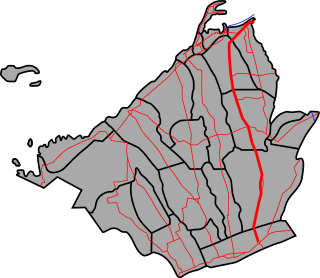
Bulan–Magallanes Road is a 15-kilometer (9.3 mi), national secondary road in Sorsogon province of the Philippines.
Gandara Diversion Road is a 1.4-kilometer (0.87 mi) national secondary road in the town of Gandara, Samar in the Philippines.
