
Transportation in the Philippines covers the transportation methods within the archipelagic nation of over 7,600 islands. From a previously underdeveloped state of transportation, the government of the Philippines has been improving transportation through various direct infrastructure projects, and these include an increase in air, sea, road, and rail transportation and transport hubs.

Metropolitan Manila, commonly shortened to Metro Manila and formally the National Capital Region, is the capital region and largest metropolitan area of the Philippines. Located on the eastern shore of Manila Bay, the region lies between the Central Luzon and Calabarzon regions. Encompassing an area of 636.00 km2 (245.56 sq mi) and with a population of 13,484,462 as of 2020, it is composed of sixteen highly urbanized cities: the capital city, Manila, Caloocan, Las Piñas, Makati, Malabon, Mandaluyong, Marikina, Muntinlupa, Navotas, Parañaque, Pasay, Pasig, Quezon City, San Juan, Taguig, and Valenzuela, along with one independent municipality, Pateros. As the second most populous and the most densely populated region in the Philippines, it ranks as the 9th most populous metropolitan area in Asia and the 6th most populous urban area in the world.

Makati, officially the City of Makati, is a highly urbanized city in the National Capital Region of the Philippines, known for being one of the leading financial centers in the country. As of 2013, the city has the highest concentration of multinational and local corporations in the Philippines. Major banks, corporations, department stores as well as foreign embassies are based in Makati. Makati is also known for being a major cultural and entertainment hub in Metro Manila. According to the 2020 census, it had a population of 629,616 people, making it as the 47th most populous city in the country and ranked as the 43rd most densely populated city in the world with 19,336 inhabitants per square kilometer or 50,080 inhabitants per square mile.

The Pasig River is a water body in the Philippines that connects Laguna de Bay to Manila Bay. Stretching for 25.2 kilometers (15.7 mi), it bisects the Philippine capital of Manila and its surrounding urban area into northern and southern halves. Its major tributaries are the Marikina River and San Juan River. The total drainage basin of the Pasig River, including the basin of Laguna de Bay, covers 4,678 square kilometers (1,806 sq mi).

Mandaluyong, officially the City of Mandaluyong, is a highly urbanized city in the National Capital Region of the Philippines. According to the 2020 census, it has a population of 425,758 people.

Epifanio de los Santos Avenue, commonly referred to by its acronym EDSA, is a limited-access circumferential highway around Manila, the capital city of the Philippines. It passes through 6 of Metro Manila's 17 local government units or cities, namely, from north to south, Caloocan, Quezon City, San Juan, Mandaluyong, Makati, and Pasay.

The Metropolitan Manila Development Authority is a government agency of the Philippines responsible for constituting the regional government of Metro Manila, comprising the capital city of Manila, the cities of Quezon City, Caloocan, Pasay, Mandaluyong, Makati, Pasig, Marikina, Muntinlupa, Las Piñas, Parañaque, Valenzuela, Malabon, Taguig, Navotas and San Juan, and the municipality of Pateros.

The Pasig River Ferry Service (PRFS) is a public water bus service based in Metro Manila, the Philippines. It is currently the only water-based transportation service in Metro Manila that cruises the length of the Pasig River and Marikina River, passing through the cities of Manila, Makati, Mandaluyong, Pasig, Marikina, and Taguig.

The transportation system in Metro Manila covers the road network, rail network, ferries, ports and airports located within the metropolitan Manila area. Road transportation in Metro Manila is diverse, composed of many types of private and public transport vehicles. These include taxis, buses, jeepneys, tricycles and pedicabs. In some areas, especially in Divisoria and large public markets, two-stroke motors are fitted in the pedicabs and are used for goods transport. Regardless of modernity, horse-drawn kalesas are still used in the streets of Binondo and Intramuros. Ridesharing services such as Grab also operate within Metro Manila.

The Magallanes Interchange is a four-level partial turbine interchange in Makati, Metro Manila, Philippines. It serves as the junction between the Osmeña Highway, Epifanio de los Santos Avenue (EDSA), and South Luzon Expressway (SLEX), intersecting with inner streets and Chino Roces Avenue as well. It is also an interchange between the two train lines of Metro Manila, the MRT-3, which is over EDSA, and the PNR Metro Commuter Line beside Osmeña Highway and SLEX. It is currently one of the busiest intersections in Metro Manila.

J. P. Rizal Avenue, also known as J. P. Rizal Street, is a major local avenue in Makati and Taguig, Metro Manila, Philippines. It is a contour collector road on the south bank of the Pasig River that runs east–west from Pateros Bridge at the Taguig–Pateros boundary to its intersection with Zobel Roxas, Delpan, and Tejeron Streets at the Makati–Manila boundary. It is a component of Radial Road 4 (R-4). The avenue was named after the Philippines' national hero, Dr. José P. Rizal.

Kalayaan Avenue is a major east–west route in Makati and Taguig, Metro Manila, Philippines. For most of its length, it runs parallel to Jose P. Rizal Avenue to the north from East Rembo near Fort Bonifacio to Barangay Singkamas by the border with Santa Ana, Manila. It is interrupted by Bel-Air Village between Rockwell Drive and Epifanio de los Santos Avenue (EDSA). The avenue east of EDSA is designated as a component of National Route 190 of the Philippine highway network.

The Marcos Bridge is a road bridge that connects the Barangays of Calumpang and Barangka in Marikina in Metro Manila, Philippines

The following is an alphabetical list of articles related to the Philippine capital region of Metro Manila.
The Estrella–Pantaleon Bridge, also known as the Rockwell Bridge, is a four-lane box girder bridge crossing the Pasig River in Metro Manila, Philippines. It connects Estrella Street in Makati on the south bank of the Pasig River, to Pantaleon Street via Barangka Drive in Mandaluyong on the north bank, near the site of the Acqua Private Residences.

The Makati Park and Garden, sometimes called Fort Bonifacio Riverside Park and Liwasang Bonifacio by local residents, is an urban riverfront park along the south bank of the Pasig River in Taguig, Philippines. It was created in 2001 as part of the Linear Parks Project of the Pasig River Rehabilitation Commission and the park has an area of 35,433 square meters (381,400 sq ft). In the aftermath of the 2021 Supreme Court decision, which was decided in favor of the City of Taguig gaining jurisdiction of Fort Bonifacio and the Embo barangays, ownership and management of the park has been disputed between the cities of Makati and Taguig.

The Metro Manila Subway, formerly known as the Mega Manila Subway (MMS) is an under-construction underground rapid transit line in Metro Manila, Philippines. The 33-kilometer (21 mi) line, which will run north–south between Valenzuela, Quezon City, Pasig, Taguig, Parañaque and Pasay, consists of 17 stations between the East Valenzuela and Bicutan stations. It will become the country's second direct airport rail link after the North–South Commuter Railway, with a branch line to Ninoy Aquino International Airport.

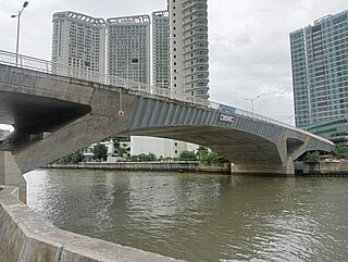
The Makati–Mandaluyong Bridge is a four-lane road bridge crossing the Pasig River between Makati and Mandaluyong in Metro Manila, Philippines. It connects P. Burgos Extension, a continuation of Makati Avenue in Poblacion, Makati at the south bank of the river to Coronado Street in Hulo, Mandaluyong at its north bank. The bridge was opened in 1986.

