List of crossings of the Pasig River

Last updated

Metro Manila location map.svg
Red pog.svg
1
Red pog.svg
2
Red pog.svg
3
Red pog.svg
4
Red pog.svg
5
Red pog.svg
6
Red pog.svg
7
Red pog.svg
8
Red pog.svg
9
Red pog.svg
10
Red pog.svg
11
Red pog.svg
12
Red pog.svg
13
Red pog.svg
14
Red pog.svg
15
Red pog.svg
16
Red pog.svg
17
Red pog.svg
18
Red pog.svg
19
Red pog.svg
20
Locations of the bridges within Metro Manila that span the Pasig

This is a list of bridges and other crossings of the Pasig River in Metro Manila, Philippines.

Contents

The crossings are listed in order starting from its mouth at Manila Bay and proceeding upstream to its source at Laguna de Bay.

As of 2023, there are a total of 24 bridges spans in Metro Manila that cross the Pasig River, including three rail bridges, carrying the LRT Line 1, MRT Line 3 and the Philippine National Railways track, and one pedestrian bridge in Santa Ana, Manila. Skyway is the first and only tollway bridge crosses the river.

The planned Metro Manila Subway will also cross the Pasig River between Pasig and Makati, making it the first tunnel to cross the river and the proposed MRT Line 10 is the fourth rail bridge parallel to the existing Bagong Ilog Bridge of C-5.

Current crossings

These are arranged from the mouth at Manila Bay to the source, from Laguna de Bay.

#CrossingImageNorth bankCarriesSouth bankVertical clearanceBuiltCoordinates
1Roxas Bridge
M. Lopez Bridge [1]
08455jfManila Buildings San Nicolas Binondo Roxas Bridge River Landmarksfvf 13.jpg San Nicolas, Manila Eight lanes of AH26 (N120) sign.svg AH 26 (N120) ( Mel Lopez Boulevard ) Intramuros and Port Area, Manila 7.5 m (25 ft) [2] 1975 [3] 14°35′42″N120°57′54″E / 14.595°N 120.965°E / 14.595; 120.965
2 Binondo–Intramuros Bridge [4] [5] Binondo-Intramuros Bridge (Manila; 04-15-2022).jpg Binondo and San Nicolas, Manila Four lanes between Muelle de Binondo and Muelle de la Industria to Solana Street and Riverside Drive Intramuros, Manila8.6 m (28 ft) [2] 2022 14°35′43″N120°58′29″E / 14.59527°N 120.97481°E / 14.59527; 120.97481
3 Jones Bridge Jones Bridge ML PH (M. Onod pic) - Flickr.jpg Binondo, Manila Four lanes between Padre Burgos Avenue and Quintin Paredes Street Ermita, Manila7.6 m (25 ft) [2] 1946 14°35′42″N120°58′19″E / 14.595°N 120.972°E / 14.595; 120.972
4 MacArthur Bridge 09780jfLiwasang Bonifacio Bridge MacArthur Tunnel Landmarks Manilafvf.jpg Santa Cruz, Manila Four lanes of N150 (Philippines).svg N150 between Padre Burgos Avenue and Plaza Santa Cruz7.6 m (25 ft) [2] 1952 14°35′46″N120°58′48″E / 14.596°N 120.980°E / 14.596; 120.980
LRT Line 1 viaduct Pasig River, LRT-1 bridge (Santa Cruz, Manila)(2018-10-09).jpg Quiapo, Manila LRT Line 1 1984 14°35′46″N120°58′48″E / 14.596°N 120.980°E / 14.596; 120.980
5 Quezon Bridge Quezon Bridge (Manila; 01-01-2020).jpg Four lanes of N170 (Philippines).svg N170 between Padre Burgos Avenue and Quezon Boulevard 7.0 m (23.0 ft) [2] 1939 14°35′42″N120°59′24″E / 14.595°N 120.990°E / 14.595; 120.990
6 Ayala Bridge 0026jfCity Manila Ayala Isla Hospicio Pasig River Boulevard Bridgefvf 06.jpg San Miguel, Manila Four lanes of N180 (Philippines).svg N180 and C-1 between Ayala Boulevard and P. Casal Street4.9 m (16 ft) [2] 1908 14°35′28″N120°59′56″E / 14.591°N 120.999°E / 14.591; 120.999
7 Mabini Bridge
Nagtahan Bridge
03328jfLacson Avenue Mabini Bridge Flyover Manila Landmarksfvf 03.jpg Santa Mesa, ManilaEight lanes of N140 (Philippines).svg N140 ( C-2 ) between Quirino Avenue and Nagtahan Street Paco, Manila 7.7 m (25 ft) [2] 1945 14°35′42″N121°00′18″E / 14.595°N 121.005°E / 14.595; 121.005
8 Nagtahan Link Bridge
Padre Zamora Bridge
Nagtahan Link Bridge 3
01708jfSanta Mesa PNR Station Pandacan Railway tracks Bridges Manilafvf 10.jpg Four lanes of N141 (Philippines).svg N141 ( Paco–Santa Mesa Road ) Pandacan, Manila9.7 m (32 ft) [2] 1998 [3] 14°35′38″N121°00′43″E / 14.594°N 121.012°E / 14.594; 121.012
Pandacan Railroad Bridge WTMP Pandacan Railway Bridge and NGCP line 02.jpg Philippine National Railways Metro Commuter Line (PNR South Rail) 14°35′38″N121°00′43″E / 14.594°N 121.012°E / 14.594; 121.012
9 Skyway Stage 3 Views of Pasig River Santa Ana Makati Taguig (Metro Manila; 2023-08-14) E911a 12.jpg Santa Ana, Manila Seven lanes of Skyway Pandacan, Manila2020 14°35′23″N121°00′50″E / 14.58976°N 121.01394°E / 14.58976; 121.01394
Kalahati–Beata river ferry Ferry
10Abante Bridge
Tulay Pangarap Footbridge
Views of Pasig River Santa Ana Makati Taguig (Metro Manila; 2023-08-14) E911a 34.jpg Pedestrian bridge Santa Ana, Manila 2023 [6] 14°34′59″N121°00′42″E / 14.583°N 121.0116°E / 14.583; 121.0116 [7]
Punta–Santa Ana river ferry 85Pasig River Ferry Stations 05.jpg Ferry
11Lambingan Bridge Lambingan Bridge - Flickr.jpg Six lanes of New Panaderos Street7.6 m (25 ft) [2] 1990 [3] 14°35′10″N121°01′30″E / 14.586°N 121.025°E / 14.586; 121.025
12 Makati–Mandaluyong Bridge 09481jfMakati City Mandaluyong City Bridge Hulo Mini Park Pasig Marikina River Channelfvf 02.jpg Hulo, Mandaluyong Four lanes between P. Burgos Street and Coronado Street Poblacion, Makati 6.0 m (19.7 ft) [2] 1986 [3] 14°34′08″N121°01′48″E / 14.569°N 121.030°E / 14.569; 121.030
Hulo–Poblacion river ferry
Tawrian [8]
85Pasig River Ferry Stations 30.jpg Ferry
13 Estrella–Pantaleon Bridge
Rockwell Bridge
Estrella-Pantaleon Bridge (post-expansion) 2021-10-31.jpg Estrella Street to Pantaleon Street7.9 m (26 ft) [2] 2021 [lower-alpha 1] 14°34′01″N121°02′13″E / 14.567°N 121.037°E / 14.567; 121.037
14 Guadalupe Bridge FvfGuadalupePasigRiver0074 35.JPG Barangka Ilaya, MandaluyongTen lanes of AH26 (N1) sign.svg AH 26 (N1) ( Epifanio de los Santos Avenue ( C-4 ))Guadalupe Viejo and Guadalupe Nuevo, Makati8.0 m (26.2 ft) [2] 1966 14°34′05″N121°02′42″E / 14.568°N 121.045°E / 14.568; 121.045
MRT Line 3 bridge MRT-3 Tracks Guadalupe 6.jpg MRT Line 3 1998 14°34′05″N121°03′17″E / 14.568°N 121.054736°E / 14.568; 121.054736
15 Santa Monica–Lawton Bridge
BGC–Ortigas Link Bridge
Kalayaan Bridge
Ortigas-BGC Bridge (Makati; 06-06-2021).jpg Kapitolyo, Pasig Four lanes between Fairlane Street and Lawton Avenue Cembo and West Rembo, Taguig 2021 14°33′58″N121°03′14″E / 14.566°N 121.054°E / 14.566; 121.054
16C.P. Garcia Bridge
Bagong Ilog Bridge
C5 Bridge
Pasig–Makati Bridge
Mm-pasig-c5-bagongilog-2012.jpg Bagong Ilog, Pasig Seven lanes of C5 and N11 (Philippines).svg N11 between Carlos P. Garcia Avenue and Eulogio Rodriguez Jr. Avenue West Rembo, Taguig8.7 m (29 ft) [2] 1998 [3] 14°33′36″N121°03′58″E / 14.560°N 121.066°E / 14.560; 121.066
17Kaunlaran Bridge 03263jfFlood Control SABO Sumilang Buting Bridge Pasig City River Ferryfvf 03.jpg Santa Rosa and Sumilang, PasigTwo lanes between F. Flores Street and Lopez Jaena StreetButing, Pasig2015 [9] 14°33′22″N121°04′15″E / 14.55611°N 121.07075°E / 14.55611; 121.07075
18Bambang Bridge
Ramon Jabson Bridge
09933jfSan Joaquin Maynilad Pipelines Bambang Bridge Pasig City Riverfvf 14.jpg Bambang, PasigTwo lanes of N142 (Philippines).svg N142 (Ramon Jabson Street)San Joaquin, Pasig6.0 m (19.7 ft) [2] 1992 [3] 14°33′14″N121°04′34″E / 14.5538°N 121.07608°E / 14.5538; 121.07608
19Kalawaan Bridge
M. Jimenez Bridge
0121jfKalawaan Bambang Bridge River Streets Pasig City Riverfvf 25.jpg Two lanes of M. Jimenez StreetKalawaan, Pasig 14°33′14″N121°04′52″E / 14.554°N 121.081°E / 14.554; 121.081
20Napindan Bridge C-6 Road at Night.JPG Pinagbuhatan, PasigFour lanes of Laguna Lake Highway (C-6) Napindan, Taguig 2018 [10] 14°32′06″N121°05′42″E / 14.535°N 121.095°E / 14.535; 121.095

Notes

  1. It was originally opened in February 2011 and built as a two-lane steel bridge.

Former crossings

These are arranged from oldest to newest.

CrossingImageNorth bankCarriesSouth bankVertical clearanceBuiltDestroyedReplacement
Puente Grande Puente Grande 1794.jpg Binondo, Manila Calle Nueva (E.T. Yuchengco Street) and Paseo de las Aguadas (Calle Padre Burgos) Ermita, Manila16301863 Puente de España
Puente Colgante
Puente de Claveria
Puente claveria.jpg Quiapo, Manila South of Calle de Echague (Valderrama Street) and Paseo de Bagumbayan (Calle Padre Burgos) Ermita, Manila18521939 Quezon Bridge
Puente de Ayala (San Miguel section) San Miguel, Manila Calle Pascual Casal and Calle Concepcion (Natividad Almeda-Lopez Street)/Calle Marquez de Comillas (D. Romualdez Street) Isla de Convalecencia 18721899 Ayala Bridge (II)
Puente de Ayala (Concepcion section) Isla de Convalecencia Ermita, Manila
Puente de España
Bridge of Spain
Puente de espana.jpg Binondo, Manila Calle Nueva and Paseo de Bagumbayan (Calle Padre Burgos) Ermita, Manila18751914 Jones Bridge (I)
Santa Cruz Bridge Manila - Santa Cruz Bridge Archive 0898.jpg Santa Cruz, Manila Plaza Goiti and Arroceros Street Ermita, Manila1900 1945 MacArthur Bridge
Jones Bridge (I) Binondo, Manila Calle Rosario (Quintin Paredes Street) Ermita, Manila1919 1945 Jones Bridge (II)
Quezon Bridge (I) Quiapo, Manila South of Calle de Echague (Valderrama Street) and Paseo de las Aguadas (Calle Padre Burgos) Ermita, Manila1939 1945 Quezon Bridge (II)
Estrella–Pantaleon Bridge (I) 02670jfEstrella Pantaleon Bridge Street Pasig River Makati Cityfvf 12.jpg Hulo, Mandaluyong Estrella Street to Pantaleon Street Poblacion, Makati 2011 [11] 2019 Estrella–Pantaleon Bridge (II)

Planned crossings

These are arranged from the mouth to the source.

CrossingNorth bankCarriesSouth bankVertical clearanceProjected
completion
Coordinates
North–South Harbor Bridge [5] San Nicolas, Manila Port Area, Manila
Ayala Bridge II [5] San Miguel, Manila Carlos Palanca Sr. Street to San Marcelino Street Ermita, Manila
Beata–F.Y. Manalo Bridge [5] Santa Ana, Manila Pandacan, Manila
F. Blumentritt–Antipolo Bridge [5] Poblacion, Makati F. Blumentritt Street to Antipolo Street Makati Poblacion and Hulo
Metro Manila Subway tunnelPineda, Pasig Metro Manila Subway West Rembo, Taguig
MRT Line 10 BridgeBagong Ilog, Pasig MRT Line 10

Related Research Articles

<span class="mw-page-title-main">Metro Manila</span> Metropolitan area and region of the Philippines

Metropolitan Manila, formally the National Capital Region and commonly called Metro Manila, is the capital region and largest metropolitan area of the Philippines. The region is located on the eastern shore of Manila Bay, between the Central Luzon and Calabarzon regions. It consists of 16 highly urbanized cities: the City of Manila, Caloocan, Las Piñas, Makati, Malabon, Mandaluyong, Marikina, Muntinlupa, Navotas, Parañaque, Pasay, Pasig, Quezon City, San Juan, Taguig, and Valenzuela, and one municipality: Pateros. The region encompasses an area of 619.57 square kilometers (239.22 sq mi) and a population of 13,484,462 as of 2020. It is the second most populous and the most densely populated region in the Philippines. It is also the 9th most populous metropolitan area in Asia and the 6th most populous urban area in the world.

<span class="mw-page-title-main">Pasig River</span> Estuary in Metro Manila, Philippines

The Pasig River is a water body in the Philippines that connects Laguna de Bay to Manila Bay. Stretching for 25.2 kilometers (15.7 mi), it bisects the Philippine capital of Manila and its surrounding urban area into northern and southern halves. Its major tributaries are the Marikina River and San Juan River. The total drainage basin of the Pasig River, including the basin of Laguna de Bay, covers 4,678 square kilometers (1,806 sq mi).

<span class="mw-page-title-main">Pasig</span> Highly urbanized city in Metro Manila, Philippines

Pasig, officially the City of Pasig, is a highly urbanized city in the National Capital Region of the Philippines. According to the 2020 census, it has a population of 803,159 people.

<span class="mw-page-title-main">Taguig</span> Highly urbanized city in Metro Manila, Philippines

Taguig, officially the City of Taguig, is a 1st class highly urbanized city in Metro Manila, Philippines. According to the 2020 census, it has a population of 886,722 people. Located in the northwestern shores of Laguna de Bay, the city is known for Bonifacio Global City, one of the leading financial centers of the Philippines. Originally a fishing village during the Spanish and American colonial periods, it experienced rapid growth when former military reservations were converted by the Bases Conversion and Development Authority (BCDA) into mixed-use planned communities. Taguig became a highly urbanized city with the passage of Republic Act No. 8487 in 2004.

<span class="mw-page-title-main">EDSA</span> Limited-access circumferential highway around Metro Manila

Epifanio de los Santos Avenue, commonly referred to by its acronym EDSA, is a limited-access circumferential highway around Manila, the capital city of the Philippines, which has a maximum capacity of 288,000 vehicles a day..

<span class="mw-page-title-main">Rail transportation in the Philippines</span> Overview of rail transport in the Philippines

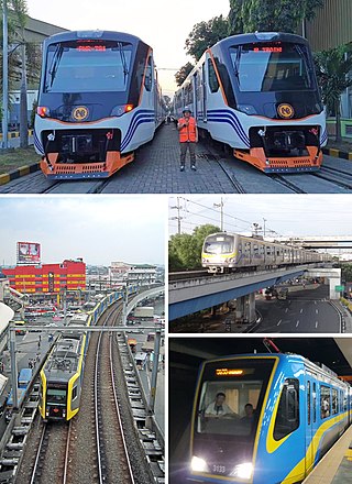
Rail transportation in the Philippines is currently used mostly to transport passengers within Metro Manila and provinces of Laguna and Quezon, as well as a commuter service in the Bicol Region. Freight transport services once operated in the country, but these services were halted. However, there are plans to restore old freight services and build new lines. From a peak of 1,100 kilometers (680 mi), the country currently has a railway footprint of 533.14 kilometers (331.28 mi), of which only 129.85 kilometers (80.69 mi) are operational as of 2023, including all the urban rail lines. World War II, natural calamities, underspending, and neglect have all contributed to the decline of the Philippine railway network. In the 2019 Global Competitiveness Report, the Philippines has the lowest efficiency score among other Asian countries in terms of efficiency of train services, receiving a score of 2.4, and ranking 86th out of 101 countries globally. The government is currently expanding the railway network up to 1,900 kilometers (1,200 mi) by 2022 through numerous projects.

<span class="mw-page-title-main">Pasig River Ferry Service</span> Water transportation in Metro Manila, the Philippines

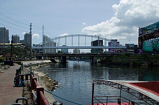
The Pasig River Ferry Service (PRFS) is a public water bus service based in Metro Manila, the Philippines. It is currently the only water-based transportation service in Metro Manila that cruises the length of the Pasig River and Marikina River, passing through the cities of Manila, Makati, Mandaluyong, Pasig, Marikina, and Taguig.

<span class="mw-page-title-main">Namayan</span>

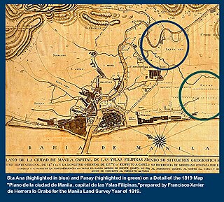
Namayan, also called Sapa, Maysapan, and sometimes Lamayan, was an independent indigenous polity on the banks of the Pasig River in the Philippines. It is believed to have achieved its peak in 1175, and to have gone into decline sometime in the 13th century, although it continued to be inhabited until the arrival of European colonizers in the 1570s.

<span class="mw-page-title-main">Transportation in Metro Manila</span> Overview of Metro Manilas transportation system

The transportation system in Metro Manila covers the road network, rail network, ferries, ports and airports located with the metropolitan Manila area. Road transportation in Metro Manila is diverse, composed of many types of private and public transport vehicles. These include Taxis, buses, jeepneys, tricycles and pedicabs. In some areas, especially in Divisoria and large public markets, two-stroke motors are fitted in the pedicabs and are used for goods transport. Regardless of modernity, horse-drawn kalesas are still used in the streets of Binondo and Intramuros. Ridesharing services such as Grab also operate within in Metro Manila.

<span class="mw-page-title-main">San Juan River (Metro Manila)</span> Major tributary of the Pasig River

The San Juan River is one of the main river systems in Metro Manila, Philippines, and is a major tributary of the Pasig River. It begins near La Mesa Dam as the San Francisco del Monte River, which officially takes the name San Juan River when it meets with Mariblo Creek in Quezon City. As the San Juan River, it passes through Quezon City, San Juan, the Manila district of Santa Mesa and Santa Ana, and Mandaluyong.

<span class="mw-page-title-main">Shaw Boulevard</span> 4–8 lane highway in the Philippines

Shaw Boulevard is a 4-8 lane highway connecting the cities of Mandaluyong and Pasig in the Philippines. The boulevard is named after William James Shaw, the founder of the Wack Wack Golf and Country Club in Mandaluyong. The road is one of the major thoroughfares of the Ortigas Center in Mandaluyong and Pasig, housing many shopping malls like the Starmall shopping center and the posh Shangri-La Plaza at the EDSA-Shaw intersection and The Marketplace, which is visible from the Kalentong-Shaw intersection and Sevilla Bridge.

<span class="mw-page-title-main">Pedro Gil Street</span> Street in Manila, Philippines

Pedro Gil Street is an east-west inner city street and a tertiary national road in south-central Manila, Philippines. It is 3.65 kilometers (2.27 mi) long and spans the entire length of Ermita, Malate, Paco, and Santa Ana. The street is served by the Pedro Gil LRT Station along Taft Avenue and the Paco railway station along Quirino Avenue. It also continues towards the central Metro Manila cities of Mandaluyong and San Juan across the Pasig River as New Panaderos and General Kalentong Streets.

<span class="mw-page-title-main">J. P. Rizal Avenue</span>

J. P. Rizal Avenue, also known as J. P. Rizal Street, is a major local avenue in Makati and Taguig, Metro Manila, Philippines. It is a contour collector road on the south bank of the Pasig River that runs east–west from Pateros Bridge at the Taguig–Pateros boundary to its intersection with Zobel Roxas, Delpan, and Tejeron Streets at the Makati–Manila boundary. The avenue was named after the Philippines' national hero, Dr. José P. Rizal.

<span class="mw-page-title-main">Circuit Makati</span> Place in Philippines

Circuit Makati is a riverfront redevelopment project by Ayala Land on the site of the former Santa Ana Race Track in Makati, Metro Manila, Philippines. The 21-hectare (52-acre) site located in the northwest portion of Makati, on the south bank of the Pasig River, is planned to contain a mixed-use entertainment complex which would include an indoor theater, a shopping mall, hotels and residential and office skyscrapers. It would also contain a football turf, skate park and an outdoor entertainment area. The development is envisioned to become the new entertainment district of Makati and the city's lifestyle hub.

<span class="mw-page-title-main">Outline of Metro Manila</span> Overview of and topical guide to Metro Manila

The following outline is provided as an overview of and topical guide to Metro Manila:

<span class="mw-page-title-main">Radial Road 5</span>

Radial Road 5, more commonly referred to as R-5, is a network of roads and bridges that all together form the fifth radial road of Manila in the Philippines. The road links the City of Manila with Mandaluyong and Pasig in the east, leading out of Metro Manila into the province of Rizal and south towards Laguna. It is the only arterial road traversing the east side of Laguna de Bay.

<span class="mw-page-title-main">Index of Metro Manila–related articles</span>

The following is an alphabetical list of articles related to the Philippine capital region of Metro Manila.

<span class="mw-page-title-main">Estrella–Pantaleon Bridge</span> Bridge in Metro Manila, Philippines

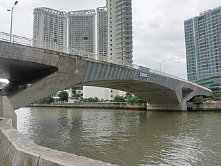
The Estrella–Pantaleon Bridge, also known as the Rockwell Bridge, is a four-lane box girder bridge crossing the Pasig River in Metro Manila, Philippines. It connects Estrella Street in Makati on the south bank of the Pasig River, to Pantaleon Street via Barangka Drive in Mandaluyong on the north bank, near the site of the Acqua Private Residences.

<span class="mw-page-title-main">Santa Monica–Lawton Bridge</span> Bridge in Metro Manila, Philippines

The Santa Monica–Lawton Bridge, also known as the Kalayaan Bridge and Bonifacio Global City–Ortigas Link Bridge, is a four-lane, two-way bridge across the Pasig River that connects Lawton Avenue in the barangays of Cembo and West Rembo in Taguig to Fairlane Street in the barangays of Kapitolyo and Pineda in Pasig. The bridge spans 613.77 meters (2,013.7 ft) and the construction cost of the bridge is ₱1.857 billion as of 2017. The bridge also includes a 565-meter (1,854 ft) viaduct that connects it to 8th Avenue in Bonifacio Global City, Taguig.

<span class="mw-page-title-main">Makati–Mandaluyong Bridge</span> Bridge in Metro Manila, the Philippines

The Makati–Mandaluyong Bridge is a four-lane road bridge crossing the Pasig River in Metro Manila, the Philippines. It connects P. Burgos Extension, a continuation of Makati Avenue in Barangay Poblacion, Makati at the south bank of the river to Coronado Street in Barangay Hulo, Mandaluyong at the north bank. The bridge was opened in 1986.

References

  1. MEL LOPEZ BRIDGE PAPAGANDAHIN NA RIN OCTOBER 19,2019 UPDATE (in Filipino). Pugong Biyahero. October 19, 2019. Event occurs at 3:06. Retrieved November 21, 2020.
  2. 1 2 3 4 5 6 7 8 9 10 11 12 13 14 Department of Public Works and Highways (August 2, 2023). "Vertical clearance of all Pasig River road bridges". Freedom of Information Philippines . Retrieved August 16, 2023.
  3. 1 2 3 4 5 6 "Detailed Bridge Inventory". Department of Public Works and Highways. Retrieved June 12, 2021.
  4. Placido, Dharel (June 29, 2017). "Construction of two China-sponsored bridges to begin this year". ABS-CBN News. Retrieved June 29, 2017.
  5. 1 2 3 4 5 Lamentillo, Anna Mae Yu (November 4, 2017). "Build Build Build: Metro Manila Logistics Infrastructure Network". Manila Bulletin . Retrieved June 11, 2020.
  6. Calucin, Diann Uvy (July 20, 2023). "Manila LGU inaugurates 'Tulay Pangarap' in Sta. Ana". Manila Bulletin. Retrieved July 22, 2023.
  7. Inauguration of Tulay Pangarap Footbridge at Sta. Ana, Manila. CINEMOTIONDIGITALFILMS 2014. July 20, 2023. Retrieved July 22, 2023.
  8. De La Cruz, Christa (December 29, 2022). "ICYDK: There's a Five-Peso Boat Ride from Mandaluyong to Makati". Spot.ph . Retrieved September 12, 2023.
  9. "Blessing and inauguration of Kaunlaran Bridge at Brgy. Sumilang and Buting". Local government of Pasig. Archived from the original on September 24, 2015. Retrieved June 27, 2015.
  10. Tapnio, Kevyn (November 16, 2018). "Getting to the Airport From Antipolo Could Be Faster and Easier With This New Highway". SPOT.PH. Retrieved April 30, 2021.
  11. "New bridge connecting Makati, Mandaluyong opened". GMA News . Retrieved June 27, 2015.