Transportation in the Philippines covers the transportation methods within the archipelagic nation of over 7,600 islands. From a previously underdeveloped state of transportation, the government of the Philippines has been improving transportation through various direct infrastructure projects, and these include an increase in air, sea, road, and rail transportation and transport hubs.

Metropolitan Manila, commonly shortened to Metro Manila and formally the National Capital Region, is the capital region and largest metropolitan area of the Philippines. Located on the eastern shore of Manila Bay, the region lies between the Central Luzon and Calabarzon regions. Encompassing an area of 636.00 km2 (245.56 sq mi) and with a population of 13,484,462 as of 2020, it is composed of sixteen highly urbanized cities: the capital city, Manila, Caloocan, Las Piñas, Makati, Malabon, Mandaluyong, Marikina, Muntinlupa, Navotas, Parañaque, Pasay, Pasig, Quezon City, San Juan, Taguig, and Valenzuela, along with one independent municipality, Pateros. As the second most populous and the most densely populated region in the Philippines, it ranks as the 9th most populous metropolitan area in Asia and the 6th most populous urban area in the world.

Makati, officially the City of Makati, is a highly urbanized city in the National Capital Region of the Philippines, known for being one of the leading financial centers in the country. As of 2013, the city has the highest concentration of multinational and local corporations in the Philippines. Major banks, corporations, department stores as well as foreign embassies are based in Makati. Makati is also known for being a major cultural and entertainment hub in Metro Manila. According to the 2020 census, it had a population of 629,616 people, making it as the 47th most populous city in the country and ranked as the 43rd most densely populated city in the world with 19,336 inhabitants per square kilometer or 50,080 inhabitants per square mile.

The Pasig River is a water body in the Philippines that connects Laguna de Bay to Manila Bay. Stretching for 25.2 kilometers (15.7 mi), it bisects the Philippine capital of Manila and its surrounding urban area into northern and southern halves. Its major tributaries are the Marikina River and San Juan River. The total drainage basin of the Pasig River, including the basin of Laguna de Bay, covers 4,678 square kilometers (1,806 sq mi).

Mandaluyong, officially the City of Mandaluyong, is a highly urbanized city in the National Capital Region of the Philippines. According to the 2020 census, it has a population of 425,758 people.

Guadalupe station is an elevated Metro Rail Transit (MRT) station located on the MRT Line 3 (MRT-3) system in Makati. It is named because of its location between the barangays of Guadalupe Nuevo and Guadalupe Viejo, both are in turn named after Our Lady of Guadalupe.
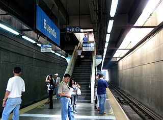
Buendia station is an underground Metro Rail Transit (MRT) station located on the MRT Line 3 (MRT-3) system in Makati. It is one of two underground stations that can be found on the line, the other being Ayala. The station lies near the EDSA–Kalayaan Flyover and Gil Puyat Avenue in Makati.

Boni station is an at-grade Metro Rail Transit (MRT) station located on the MRT Line 3 (MRT-3) system in Mandaluyong. It is named so due to its proximity to Boni Avenue, which is in turn named after the nickname of Bonifacio Javier, a World War II guerilla leader and former mayor of Mandaluyong. It has several restaurants and shops that surround the station, including a public market located across the train station.

The Pasig River Ferry Service (PRFS) is a public water bus service based in Metro Manila, the Philippines. It is currently the only water-based transportation service in Metro Manila that cruises the length of the Pasig River and Marikina River, passing through the cities of Manila, Makati, Mandaluyong, Pasig, Marikina, and Taguig.

The transportation system in Metro Manila covers the road network, rail network, ferries, ports and airports located within the metropolitan Manila area. Road transportation in Metro Manila is diverse, composed of many types of private and public transport vehicles. These include taxis, buses, jeepneys, tricycles and pedicabs. In some areas, especially in Divisoria and large public markets, two-stroke motors are fitted in the pedicabs and are used for goods transport. Regardless of modernity, horse-drawn kalesas are still used in the streets of Binondo and Intramuros. Ridesharing services such as Grab also operate within Metro Manila.
The Pasig River Expressway (PAREX) is a proposed elevated expressway in Metro Manila, Philippines that plans to skirt the banks of the Pasig River and connect the cities of Manila, Mandaluyong, Makati, Pasig, Taguig and the municipality of Taytay. The expressway is proposed to alleviate east-west traffic congestion in Metro Manila. It is visioned to be a joint venture between the Philippine National Construction Corporation and the San Miguel Corporation. The project broke ground on September 24, 2021, while construction of the expressway was yet to start pending the approval of its Environmental Compliance Certificate (ECC). The project was deemed cancelled in 2024 due to public uproar against the project. However, Ramon Ang announced renewed interest with the project, though citing the need to adjust it towards public sentiments.

Shaw Boulevard is a 4-8 lane highway connecting the cities of Mandaluyong and Pasig in the Philippines. The boulevard is named after William James Shaw, the founder of the Wack Wack Golf and Country Club in Mandaluyong. The road is one of the major thoroughfares of the Ortigas Center in Mandaluyong and Pasig, housing many shopping malls like the Starmall shopping center and the posh Shangri-La Plaza at the EDSA-Shaw intersection and The Marketplace, which is visible from the Kalentong-Shaw intersection and Sevilla Bridge.
The Metro Manila Dream Plan, formally titled the Roadmap for Transport Infrastructure Development for Metro Manila and Its Surrounding Areas, refers to a 2014 integrated plan for improving the transport system in Metro Manila, Philippines, with the hope of turning it into a focal point for addressing Metro Manila's interlinked problems in the areas of transportation, land use, and environment.

Circumferential Road 6 (C-6), informally known as the C-6 Road, is a network of roads and bridges which will comprise the sixth and outermost beltway of Metro Manila in the Philippines once completed.
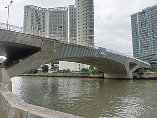
The Estrella–Pantaleon Bridge, also known as the Rockwell Bridge, is a four-lane box girder bridge crossing the Pasig River in Metro Manila, Philippines. It connects Estrella Street in Makati on the south bank of the Pasig River to Pantaleon Street via Barangka Drive in Mandaluyong on the north bank, near the site of the Acqua Private Residences.
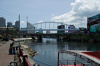
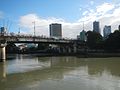
The Guadalupe Bridge is a road bridge crossing the Pasig River in Metro Manila, Philippines, linking the cities of Makati and Mandaluyong. It serves as a conduit for EDSA and the MRT Line 3.

The Santa Monica–Lawton Bridge, also known as the Kalayaan Bridge and Bonifacio Global City–Ortigas Link Bridge, is a four-lane, two-way bridge across the Pasig River that connects Lawton Avenue in the Embo barangays of Cembo and West Rembo in Taguig to Fairlane Street in barangays Kapitolyo and Pineda in Pasig. The bridge spans 613.77 meters (2,013.7 ft) and the construction cost of the bridge is ₱1.857 billion as of 2017. The bridge also includes a 565-meter (1,854 ft) viaduct that connects it to 8th Avenue in Bonifacio Global City, Taguig.

Plainview is an urban barangay in Mandaluyong, Metro Manila, Philippines. It is home to the city's seat of government and was originally the site of the Plainview residential subdivision.