Nagbukel

Last updated
Nagbukel
Municipality of Nagbukel
Nagbukel Ilocos Sur.png
Ph locator ilocos sur nagbukel.png
Map of Ilocos Sur with Nagbukel highlighted
OpenStreetMap
Nagbukel
Philippines location map (square).svg
Red pog.svg
Nagbukel
Location within the Philippines
Coordinates: 17°26′49″N120°31′31″E / 17.4469°N 120.5253°E / 17.4469; 120.5253
Country Philippines
Region Ilocos Region
Province Ilocos Sur
District 2nd district
Founded 1896
Barangays 12 (see Barangays)
Government
[1]
  Type Sangguniang Bayan
   Mayor Amalia C. Cabrera
   Vice Mayor Randolf John C. Cabrera
   Representative Kristine Singson-Meehan
   Municipal Council
Members
  • Alicia B. Sambajon
  • Orlando C. Cabang
  • Virgilio A. Baguang
  • Carlo R. Pascua
  • Oscar B. Cabunoc
  • Loida A. Tumbaga
  • Merlyn C. Domingo
  • Zenaida M. Montante
   Electorate 4,026 voters (2025)
Area
[2]
  Total
43.12 km2 (16.65 sq mi)
Elevation
87 m (285 ft)
Highest elevation
547 m (1,795 ft)
Lowest elevation
4 m (13 ft)
Population
 (2024 census) [3]
  Total
5,370
  Density120/km2 (320/sq mi)
   Households
1,361
Economy
   Income class 5th municipal income class
   Poverty incidence
17.96
% (2021) [4]
   Revenue 418.3 million (2022)
   Assets 1,491 million (2022)
   Expenditure 86.03 million (2022)
   Liabilities 36.18 million (2022)
Service provider
  ElectricityIlocos Sur Electric Cooperative (ISECO)
Time zone UTC+8 (PST)
ZIP code
2725
PSGC
IDD : area code +63(0)77
Native languages Ilocano
Tagalog
Website www.nagbukel.gov.ph

Nagbukel, officially the Municipality of Nagbukel (Ilocano : Ili ti Nagbukel; Filipino : Bayan ng Nagbukel), is a municipality in the province of Ilocos Sur, Philippines. According to the 2020 census, it has a population of 5,465 people. [5]

Contents

Nagbukel is 39 kilometres (24 mi) from Vigan and 382 kilometres (237 mi) from Manila.

Etymology

The name of the municipality is thought to have come from the round shape of one of the hills in the area. People in the area would utter, "Anian nga nagbukel" (Ilocano meaning "How round it is.").

Another origin of the municipality's name comes from three small hills in the southern part of the municipality.

Still another origin of the town's name comes from the irregular distribution of the barangays of Nagbukel and nearby Narvacan. Negotiations were made in such a way that the place east of the Kayapa River become part of Nagbukel and places west of the river become part of Narvacan. The distance from north to south was equal to the distance from east to west. The resulting area is round, hence the name "Nagbukel."

History

The barrios that compose the municipality today were formerly a part of Narvacan. However, in 1896, Nagbukel became a town under the Spanish colonial government. It was only in 1899 that the town became a regular municipality.[ citation needed ]

Geography

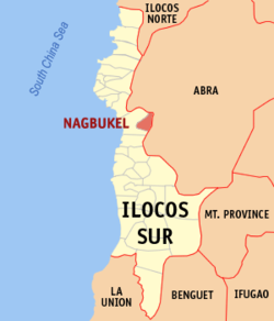
Nagbukel is situated 38.29 kilometres (23.79 mi) from the provincial capital Vigan, and 379.53 kilometres (235.83 mi) from the country's capital city of Manila.

Barangays

Nagbukel is politically subdivided into 12 barangays. [6] Each barangay consists of puroks and some have sitios.

  • Balaweg
  • Bandril
  • Bantugo
  • Cadacad
  • Casilagan
  • Casocos
  • Lapting
  • Mapisi
  • Mission
  • Poblacion East
  • Poblacion West
  • Taleb

Climate

Climate data for Nagbukel, Ilocos Sur
MonthJanFebMarAprMayJunJulAugSepOctNovDecYear
Mean daily maximum °C (°F)30
(86)
31
(88)
33
(91)
34
(93)
32
(90)
31
(88)
30
(86)
30
(86)
30
(86)
31
(88)
31
(88)
30
(86)
31
(88)
Mean daily minimum °C (°F)19
(66)
19
(66)
21
(70)
23
(73)
24
(75)
25
(77)
24
(75)
24
(75)
24
(75)
22
(72)
21
(70)
19
(66)
22
(72)
Average precipitation mm (inches)10
(0.4)
10
(0.4)
14
(0.6)
23
(0.9)
80
(3.1)
103
(4.1)
121
(4.8)
111
(4.4)
119
(4.7)
144
(5.7)
39
(1.5)
15
(0.6)
789
(31.2)
Average rainy days5.23.96.29.118.521.422.919.819.816.210.56.1159.6
Source: Meteoblue (modeled/calculated data, not measured locally) [7]

Demographics

Population census of Nagbukel
YearPop.±% p.a.
1918 1,979    
1939 2,497+1.11%
1948 2,345−0.70%
1960 2,874+1.71%
1970 2,978+0.36%
YearPop.±% p.a.
1975 3,226+1.62%
1980 3,539+1.87%
1990 3,806+0.73%
1995 4,124+1.51%
2000 4,671+2.71%
YearPop.±% p.a.
2007 4,764+0.27%
2010 4,938+1.31%
2015 5,259+1.21%
2020 5,465+0.81%
2024 5,370−0.42%
Source: Philippine Statistics Authority [8] [9] [10] [11] [12]

In the 2020 census, Nagbukel had a population of 5,465. [13] The population density was 130 inhabitants per square kilometre (340/sq mi).

Economy

Poverty incidence of Nagbukel

10
20
30
40
50
60
2000
50.73
2003
38.19
2006
26.00
2009
28.40
2012
30.30
2015
16.86
2018
6.52
2021
17.96

Source: Philippine Statistics Authority [14] [15] [16] [17] [18] [19] [20] [21]

Government

Local government

Nagbukel, belonging to the second congressional district of the province of Ilocos Sur, is governed by a mayor designated as its local chief executive and by a municipal council as its legislative body in accordance with the Local Government Code. The mayor, vice mayor, and the councilors are elected directly by the people through an election which is being held every three years.

Elected officials

Members of the Municipal Council
(2019–2022) [22]
PositionName
CongressmanKristine Singson-Meehan
MayorAmalia C. Cabrera
Vice-MayorRandolf John C. Cabrera
CouncilorsAlicia B. Sambajon
Orlando C. Cabang
Virgilio A. Baguang
Carlo R. Pascua
Oscar B. Cabunoc
Loida A. Tumbaga
Merlyn C. Domingo
Zenaida M. Montante

Education

All educational institutions within the municipality of Nagbukel are managed by the Department of Education. These are governed and managed by schools district offices located in Narvacan, a nearby town, namely Navacan North Schools District Office, and Narvacan South Schools District Office. [23]

Primary and elementary schools

Secondary schools

References

  1. Municipality of Nagbukel | (DILG)
  2. "2015 Census of Population, Report No. 3 – Population, Land Area, and Population Density" (PDF). Philippine Statistics Authority. Quezon City, Philippines. August 2016. ISSN   0117-1453. Archived (PDF) from the original on May 25, 2021. Retrieved July 16, 2021.
  3. "2024 Census of Population (POPCEN) Population Counts Declared Official by the President". Philippine Statistics Authority. 17 July 2025. Retrieved 18 July 2025.
  4. "PSA Releases the 2021 City and Municipal Level Poverty Estimates". Philippine Statistics Authority. 2 April 2024. Retrieved 28 April 2024.
  5. "2024 Census of Population (POPCEN) Population Counts Declared Official by the President". Philippine Statistics Authority. 17 July 2025. Retrieved 18 July 2025.
  6. "Province:". PSGC Interactive. Quezon City, Philippines: Philippine Statistics Authority . Retrieved 12 November 2016.
  7. "Nagbukel: Average Temperatures and Rainfall". Meteoblue. Retrieved 14 May 2020.
  8. "2024 Census of Population (POPCEN) Population Counts Declared Official by the President". Philippine Statistics Authority. 17 July 2025. Retrieved 18 July 2025.
  9. Census of Population (2015). "Region I (Ilocos Region)". Total Population by Province, City, Municipality and Barangay. Philippine Statistics Authority . Retrieved 20 June 2016.
  10. Census of Population and Housing (2010). "Region I (Ilocos Region)" (PDF). Total Population by Province, City, Municipality and Barangay. National Statistics Office . Retrieved 29 June 2016.
  11. Censuses of Population (1903–2007). "Region I (Ilocos Region)". Table 1. Population Enumerated in Various Censuses by Province/Highly Urbanized City: 1903 to 2007. National Statistics Office.
  12. "Province of". Municipality Population Data. Local Water Utilities Administration Research Division. Retrieved 17 December 2016.
  13. "2024 Census of Population (POPCEN) Population Counts Declared Official by the President". Philippine Statistics Authority. 17 July 2025. Retrieved 18 July 2025.
  14. "Poverty incidence (PI):". Philippine Statistics Authority. Retrieved December 28, 2020.
  15. "Estimation of Local Poverty in the Philippines" (PDF). Philippine Statistics Authority. 29 November 2005.
  16. "2003 City and Municipal Level Poverty Estimates" (PDF). Philippine Statistics Authority. 23 March 2009.
  17. "City and Municipal Level Poverty Estimates; 2006 and 2009" (PDF). Philippine Statistics Authority. 3 August 2012.
  18. "2012 Municipal and City Level Poverty Estimates" (PDF). Philippine Statistics Authority. 31 May 2016.
  19. "Municipal and City Level Small Area Poverty Estimates; 2009, 2012 and 2015". Philippine Statistics Authority. 10 July 2019.
  20. "PSA Releases the 2018 Municipal and City Level Poverty Estimates". Philippine Statistics Authority. 15 December 2021. Retrieved 22 January 2022.
  21. "PSA Releases the 2021 City and Municipal Level Poverty Estimates". Philippine Statistics Authority. 2 April 2024. Retrieved 28 April 2024.
  22. "2019 National and Local Elections" (PDF). Commission on Elections. Retrieved March 11, 2022.
  23. "Masterlist of Schools" (PDF). Department of Education. January 15, 2021. Retrieved April 17, 2025.