Pinatubo is known for its VEI-6 eruption on June 15, 1991, the second-largest terrestrial eruption of the 20th century after the 1912 eruption of Novarupta in Alaska.[7] The eruption coincided with Typhoon Yunya making landfall in the Philippines, which brought a dangerous mix of ash and rain to nearby towns and cities. Early predictions led to the evacuation of tens of thousands of people, saving many lives. The eruption severely damaged surrounding areas with pyroclastic surges, pyroclastic falls, and later, flooding lahars caused by rainwater re-mobilizing volcanic deposits. This destruction affected infrastructure and altered river systems for years.[7][8] Minor dome-forming eruptions inside the caldera continued from 1992 to 1993.
The 1991 eruption had worldwide effects. It released roughly 10billiontonnes (1.1×10¹⁰short tons) or 10km3 (2.4cumi) of magma, bringing large amounts of minerals and toxic metals to the surface. It also released 20million tonnes (22million short tons) of SO 2. It ejected more particulate into the stratosphere than any eruption since Krakatoa in 1883. In the following months, aerosols formed a global layer of sulfuric acid haze. Global temperatures dropped by about 0.5°C (0.9°F) in the years 1991–1993,[9] and ozone depletion temporarily increased significantly.[10]
Geography
Mount Pinatubo relief map
The volcano is about 87 kilometers (54mi) northwest of Manila, the capital of the Philippines. Near Mount Pinatubo are former military bases that were maintained by the United States. The U.S. Naval Base Subic Bay was 37 kilometers (23mi) south of Pinatubo, and the extent of Clark Air Base was just 14 kilometers (8.7mi) east of the volcano's summit.[11] The volcano is near to about 6 million people.[12]
History
Even before the 1991 eruption, Mount Pinatubo had little topographic prominence: it was 1,745m (5,725ft) above sea level, only about 600m (2,000ft) above nearby plains, and only about 200m (660ft) higher than surrounding peaks, which largely obscured it from view.[13] It is part of a chain of volcanoes which lie along the western side of the island of Luzon called the Zambales Mountains.[14]
Pinatubo is flanked on the west by the ZambalesOphiolite Complex, which is an easterly-dipping section of Eocene oceanic crust uplifted during the late Oligocene. The Tarlac Formation north, east and southeast of Pinatubo consists of marine, nonmarine and volcanoclastic sediments formed in the late Miocene and Pliocene.[17]
The most recent study of Mount Pinatubo before the activities of 1991 was the overall geological study in 1983 and 1984 made by F. G. Delfin for the Philippine National Oil Company as part of the surface investigations of the area before exploratory drilling and well testing for geothermal energy sources in 1988 to 1990. He recognized two life histories of the mountain, which he classified as "ancestral" and "modern" Pinatubo.[17][18]
Ancestral Pinatubo
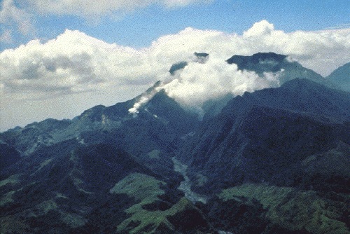
Aerial view of Mount Pinatubo before the 1991 eruption, March 1933Pinatubo in April 1991, approximately two months before the eruption.
Activity of Ancestral Pinatubo seems to have begun about 1.1million years ago and probably ended tens of thousands of years or more before the birth of "modern" Pinatubo. Much of the rugged land around the present volcano consists of remnants of "ancestral" Pinatubo. It was an andesite and dacitestratovolcano whose eruptive activity was much less explosive than modern Pinatubo. Its center was roughly where the current volcano is. The projected height of the mountain is up to 2,300m (7,500ft), or 1.43 miles above sea level if it were a lone peak, based on a profile fitting to the remaining lower slopes, or lower if it had more than one peak.[17]
The old volcano is exposed in the walls of an old 3.5km ×4.5km (2.2mi ×2.8mi) wide caldera, referred to as Tayawan Caldera by Delfin. Some of the nearby peaks are the remnants of ancestral Pinatubo, left behind when the softer parts of the old mountain slopes were eroded by weathering. Ancestral Pinatubo is a somma volcano with modern Pinatubo as the new cone. Mount Dorst, to the east, is part of the dip slope of the ancestral Pinatubo. Several mountains near modern Pinatubo are old satellite vents of ancestral Pinatubo, forming volcanic plugs and lava domes. These satellite vents were probably active around the same time as the ancestral volcano and include the domes of Mount Negron, Mount Cuadrado, Mount Mataba and the Bituin and Tapungho plugs.[17]
Modern Pinatubo
c.79,000 BC:[21] After a long period of dormancy, Modern Pinatubo was born in Ancestral Pinatubo's cataclysmic and most explosive eruptions, estimated to be five times larger than the June 1991 eruption. It deposited all around the volcano up to 25km3 (6.0cumi) of pyroclastic surge material up to 100 meters (330ft) thick. The total volume of volcanic material ejected during the eruptions is unknown. The removal of so much material from the underlying magma chamber resulted in the Tayawan caldera. The violent eruptive period started by the eruption is referred to by Delfin as the Inararo Eruptive Period, named after a village that was destroyed in the 1991 eruption.[17]
Later eruptions of modern Pinatubo occurred episodically and lasted for periods much shorter than the repose intervals between them. Subsequent eruptions and eruptive period occurred about:
c. 15,000 BC (Sacobia Eruptive Period)
c. 7000 BC (Pasbul Eruptive Period). Its eruptions were as energetic, if not as voluminous as the Inararo eruptions.
c. 4000–3000 BC (Crow Valley Eruptive Period). This and the Mara-unot period's eruptions were smaller than the Inararo eruptions but about two to three times as big as that of 1991 based on the pyroclastic flow runout distances and depths of valley filling.
c. 1900–300 BC (Maraunot Eruptive Period)
c. AD 1500 (Buag Eruptive Period). Its eruptions were roughly the same size as those of 1991.
Each of these eruptions seems to have been very large, ejecting more than 10km3 (2.4cumi) of material and covering large parts of the surrounding areas with pyroclastic flow deposits. Some eruptive periods have lasted decades and perhaps as much as several centuries and might appear to include multiple large explosive eruptions.[17]
The maximum size of eruptions in each eruptive period though has been getting smaller through the more than 35,000-year history of modern Pinatubo, but this might be an artifact of erosion and burial of older deposits. The oldest eruption of modern Pinatubo, Inararo, was also its largest.
The 1991 eruption was among the smallest documented in its geologic record.[17]
The volcano has never grown very large between eruptions, because it produces mostly unwelded, easily erodible deposits and periodically destroys the viscous domes that fill its vents. After the Buag eruption (c. 1500 AD), the volcano lay dormant, its slopes becoming completely covered in dense rainforest and eroded into gullies and ravines. The c. 500-year repose though between the Buag and present eruptive periods is among the shorter repose periods recognized in its geologic history.[17]
The eruption column of Mount Pinatubo on June12, 1991, three days before the climactic eruptionView to the west from Clark Air Base of the major eruption of Pinatubo on June 15, 1991. The June 15–16 climatic phase lasted more than fifteen hours, sent tephra about 35km (22mi) into the atmosphere, generated voluminous pyroclastic flows, and left a caldera in the former summit region. Later dubbed Black Saturday, the day of darkness stretched for 36 hours.
In March and April 1991, magma rising toward the surface from more than 32km (20mi) beneath Pinatubo triggered small volcano tectonic earthquakes and caused powerful steam explosions that blasted three craters on the north flank of the volcano. Thousands of small earthquakes occurred beneath Pinatubo through April, May and early June and many thousand of tons of noxious sulfur dioxide gas were also emitted by the volcano.[7] From June 7 to 12, the first magma reached the surface of Mount Pinatubo. Because it had lost most of the gas contained in it on the way to the surface, the magma oozed out to form a lava dome but did not cause an explosive eruption.
A small blast at 3:41 PST on June 12 marked the beginning of a new, more violent phase of the eruption as millions of cubic yards of gas-charged magma reached the surface and exploded in the reawakening volcano's first spectacular eruption.[7] A few hours later the same day, massive blasts lasting about half an hour generated big eruption columns, which quickly reached heights of over 19 kilometres (62,000ft) and which generated large pyroclastic surges extending up to four kilometres (2.5mi) from the summit in some river valleys. Fourteen hours later, a 15-minute blast hurled volcanic matter to heights of 24km (15mi). Friction in the up-rushing ash column generated abundant volcanic lightning.
When even more highly gas-charged magma reached Pinatubo's surface on June 15, the volcano exploded in a cataclysmic eruption that ejected more than 5km3 (1.2mi3) of material. The ash cloud from this climactic eruption rose 35km (22mi) into the atmosphere. At lower altitudes, the volcanic ash was blown in all directions by the intense cyclonic winds of a coincidentally occurring typhoon, and winds at higher altitudes blew the ash southwestward. A blanket of ash and larger pumicelapilli blanketed the countryside. Fine ash fell as far away as the Indian Ocean and satellites tracked the ash cloud several times around the globe.[7]
Huge pyroclastic flows roared down the flanks of Mount Pinatubo, filling once-deep valleys with fresh volcanic deposits as much as 200m (660ft) thick. The eruption removed so much magma and rock from below the volcano that the summit collapsed to form a 2.5km (1.6mi) wide caldera.[7]
Following the climactic eruption of June 15, 1991, activity at the volcano continued at a much lower level, with continuous ash eruptions lasting until August 1991 and episodic eruptions continuing for another month.
The location of Mount Pinatubo and the regional ash fallout from the 1991 eruption
Later eruptions
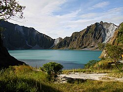
Lake Pinatubo, the crater lake resulting from the 1991 eruption, pictured here in 2008
Activity at the volcano remained low until July 1992 when a new lava dome started growing in the caldera. Volcanologists suspected that further violent eruptions could be possible, and some areas were evacuated. However, the eruption was only minor. The last eruption of Mount Pinatubo took place in 1993.[2]
An aerial view of Mt. Pinatubo and Lake Pinatubo in 2006
The 1991 caldera afterwards filled with water from annual monsoon rains and a crater lake, Lake Pinatubo, was formed. In 1992, a growing lava dome formed an island, which was eventually submerged by the lake. Initially, the lake was hot and highly acidic, with a minimum pH of 2 and a temperature of about 40°C (104°F). Subsequent rainfall cooled and diluted the lake, lowering the temperature to 26°C (79°F) and raising the pH to 5.5 by 2003.
The lake deepened by about 1 meter (3.3ft) per month on average, eventually submerging the lava dome, until September 2001, when fears that the walls of the crater might be unstable prompted the Philippine government to order a controlled draining of the lake. An estimated 9,000people were once again evacuated from surrounding areas in case a large flood was accidentally triggered. Workers cut a 5-meter (16ft) notch in the crater rim and drained about a quarter of the lake's volume.[22]
Recent activity
The Mount Pinatubo (Drone footage)
On July 10, 2002, the west wall of the crater collapsed, slowly releasing approximately 160million cubic meters (5.7×10^9cuft) of water and sediment into the Maraunot River in Botolan, Zambales.[23]
On July 26, 2011, a 5.9 magnitude earthquake struck close to Pinatubo; however, no major damages or casualties were reported.[24]
On March 4, 2021, the PHIVOLCS raised Alert Level 1 over Mount Pinatubo after reporting an increase on its seismic activity. Since January 2021, 1,722 volcanic earthquakes have been recorded within the vicinity of the volcano.[25]
On August 12, 2021, PHIVOLCS said it noted a "significant decrease" in volcanic earthquakes, with a total of 104 quakes or an average 2–3 events per day recorded from July 1 to August 1, 2021. The agency also downgraded Mt. Pinatubo's Alert Level 1 to Level 0, due to "continued decrease in earthquake activity and a return to baseline seismic parameters."[26]
On November 30, 2021, PHIVOLCS reported that a weak explosion occurred at Mt. Pinatubo between 12:09p.m. and 12:13p.m. (PST), which produced a plume.[27] The agency later confirmed it was a phreatic explosion produced by hydrothermal fluids near the surface, rather than a magmatic eruption.[28]
On August 7, 2025, the Philippine Institute of Volcanology and Seismology (PHIVOLCS) reported that earthquake-monitoring equipment at the San Jose observation station in Tarlac was stolen.[29] The stolen instruments were valued at approximately ₱1.2 million, according to PHIVOLCS.[30]
Cultural history
The word pinatubo could mean "fertile place where one can make crops grow", or could mean "made to grow", in Sambal and Tagalog, which may suggest a knowledge of its previous eruption in about 1500AD. There is a local oral tradition suggestive of a folk memory of earlier large eruptions. An ancient legend tells of Bacobaco, a terrible spirit of the sea, who could metamorphose into a huge turtle and throw fire from his mouth. In the legend, when being chased by the spirit hunters, Bacobaco flees to the mountain and digs a great hole in its summit showering the surrounding land with rock, mud, dust and fire for three days; howling so loudly that the earth shakes.[31]
History among Aetas
Aeta elders tell many stories about the history of the mountain, the best known being that it was once a Batung Mabye (Kapampangan language for "living stone"). It was said to have been planted on a kingdom by a displeased sorcerer but relocated by a hero. The mountain was soon turned into the abode of Apo Namalyari ("The lord of happenings/events"), the pagan deity of the Sambal, Aetas and Kapampangans living on the Zambales range.[32]
It was said to comprise the whole mountain range until Sinukuan of Mount Arayat (the god of the Kapampangans) became a strong rival of Namalyari. Their fight, which took place over the center plains, shattered the mountain into smaller bodies and Mount Arayat lost its center peak. Other versions have it that Pinatubo's peak shattered because of Namalyari's immense fury in an attempt to teach humans the meaning of fear and show how misdeeds will be punished.[32]
According to the native elders, Apo Namalyari induced the June 1991 eruption because of displeasure toward illegal loggers and Philippine National Oil Company executives who performed deep exploratory drilling and well testing on the volcano looking for geothermal heat from 1988 to 1990.[33] Discouraging results from the wells forced the abandonment of the prospect 13 months before the April 2, 1991, explosions.[34]
Aetas granted ownership of Pinatubo
After being driven away by the 1991 eruption of Mount Pinatubo, in May 2009 some 454 Aeta families in Pampanga were given the first clean ancestral land ownership on Mount Pinatubo with the Certificate of Ancestral Domain Title (CADT) by the National Commission on Indigenous Peoples (NCIP), the government agency that deals with issues concerning indigenous people of the Philippines. The approved and declared net land area of 7,440.1ha (18,385 acres) covers the barangays of Mawakat and Nabuklod in Floridablanca, Pampanga, plus a portion of San Marcelino, Zambales, and a portion of Barangay Batiawan in Subic, Zambales.[35]
On January 14, 2010, some 7,000 Aeta families from Zambales were officially granted the Certificate of Ancestral Domain Title (CADT) covering the Zambales side of Pinatubo which includes the summit and Lake Pinatubo, officially becoming their lutan tua (ancestral land). The ancestral domain title covers 15,984ha (39,500 acres) and includes the villages of Burgos, Villar, Moraza and Belbel in Botolan and portions of the towns of Cabangan, San Felipe and San Marcelino.[36][37]
Ancestral domain titles are awarded to a certain community or indigenous group who have occupied or possessed the land continuously in accordance with their customs and traditions since time immemorial. They have the legal right to collectively possess and to enjoy the land and its natural resources to the exclusion of others.[37] Having the land title will protect them from others – including foreigners – exploiting their land without compensation to and consent from the indigenous tribes. In the past, the Aetas had to contend with mining companies, loggers, and recently, tourist companies who earn from Mount Pinatubo but do not compensate the local tribes.[37]
Since June 15, 1991, the recent caldera and Lake Pinatubo have become a tourist attraction. The preferred route is through Barangay Santa Juliana in Capas, Tarlac.[40]
In April 2025, Aeta communities held a protest, calling attention to their exclusion from revenues from tourism on Mount Pinatubo. The protesters said that their calls for the NCIP to address the issue had been ignored.[41][42] Indigenous rights activist Beverly Longid of KATRIBU said that the NCIP has a history of neglecting the Aeta indigenous peoples. Longid stated that there is a need to recognize "the Aeta and their rights over their ancestral land and territory".[42]
Biodiversity
Mammals
The Long-nosed forest mouse (Apomys sacobianus) is a species of rodent endemic to Mount Pinatubo, Philippines.[43]
↑Rodolfo, K.S. & Umbal, J.V. (2008) "A prehistoric lahar-dammed lake and eruption of Mount Pinatubo described in a Philippine aborigine legend", J. Volcanol. Geotherm. Res., 176, 432–437
12Heaney, Lawrence R.; Balete, Danilo S.; Veluz, Maria Josefa; Steppan, Scott J.; Esselstyn, Jacob A.; Pfeiffer, Andrew W.; Rickart, Eric A. (January 2014). "Two new species of Philippine forest mice (Apomys, Muridae, Rodentia) from Lubang and Luzon Islands, with a redescription of Apomys sacobianus Johnson, 1962". Proceedings of the Biological Society of Washington. 126 (4): 395–413. doi:10.2988/0006-324X-126.4.395. S2CID49347286.
Self S.; Zhao, Jing-Xia; Holasek, R.E.; Torres, R.C.; King, A.J. (1998). Newhall, C.G.; Punongbayan, R.S. (eds.). Fire and Mud, Eruptions and Lahars of Mount Pinatubo, Philippines. Washington: Smithsonian Institution – Global Volcanism Program. p.1126. Archived from the original on November 17, 2017. Retrieved April 21, 2010. The atmospheric impact of the 1991 Mount Pinatubo eruption
Stimac, James A.; Goff, Fraser; Counce, Dale; Larocque, Adrienne C. L.; Hilton, David R.; Morgenstern, Uwe (2004). "The crater lake and hydrothermal system of Mount Pinatubo, Philippines: Evolution in the decade after eruption". Bulletin of Volcanology. 66 (2): 149–167. Bibcode:2004BVol...66..149S. doi:10.1007/s00445-003-0300-3. S2CID128408824.
Wiesner, Martin G.; Wetzel, Andreas; Catane, Sandra G.; Listanco, Eddie L.; Mirabueno, Hannah T. (2004). "Grain size, areal thickness distribution and controls on sedimentation of the 1991 Mount Pinatubo tephra layer in the South China Sea". Bulletin of Volcanology. 66 (3): 226–242. Bibcode:2004BVol...66..226W. doi:10.1007/s00445-003-0306-x. S2CID128818475.
This page is based on this Wikipedia article Text is available under the CC BY-SA 4.0 license; additional terms may apply. Images, videos and audio are available under their respective licenses.


