This article needs additional citations for verification .(July 2008) |

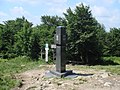
A triple border, tripoint, trijunction, [1] triple point, or tri-border area is a geographical point at which the boundaries of three countries or subnational divisions meet. As of 2020, there are 175 international tripoints in the world. [2] Nearly half are situated in rivers, lakes or seas. On dry land, the exact tripoints may be indicated by markers or pillars, and occasionally by larger monuments.
Contents
Usually, the more neighbours a country has, the more international tripoints that country has. China with 16 international tripoints and Russia with 11 to 14 lead the list of states by number of international tripoints. Other countries, like Brazil, India, and Algeria, have several international tripoints. Argentina has four international tripoints. South Africa, Pakistan and Nigeria have three international tripoints, Guatemala has two: one with Mexico and Belize, and one with Honduras and El Salvador; while Bangladesh and Mexico have one. Within Europe, landlocked Austria has nine tripoints, among them two with Switzerland and Liechtenstein. Island countries, such as Japan and Australia, generally have no international tripoints, although some, like Bahrain and Singapore, have tripoints in their territorial waters. Countries with only one neighbouring country, such as Portugal or Lesotho, also have no international tripoints. Landlocked countries also have international tripoints. Likewise, the United States with two neighbouring countries has no international tripoints; however, it has a number of state tripoints as well as one point where four states meet. Indonesia has no international tripoints, just like Australia, Japan and the United States. Canada, as well, which has a maritime border with two other countries, has no international tripoints; however, it has five tripoints on land where the boundaries of provinces and territories meet, and one quadripoint where four provinces and territories meet. Japan has multiple prefectural tripoints; it also has prefectural quadripoints. In addition to the United States, Canada and Indonesia, Australia also has tripoints where the boundaries of states meet.
Border junctions (or "multiple points" or "multipoints" as they are also sometimes called) are most commonly threefold. There are also a number of quadripoints, and a handful of fivefold points, as well as unique examples of sixfold, sevenfold, and eightfold points (see quadripoint § Multipoints of greater numerical complexity). The territorial claims of six countries converge at the South Pole in a point of elevenfold complexity, though this is an example of points subject to dispute.