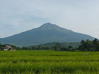
Mayon, also known as Mount Mayon and Mayon Volcano, is an active stratovolcano in the province of Albay in Bicol, Philippines. A popular tourist spot, it is renowned for its "perfect cone" because of its symmetric conical shape, and is regarded as sacred in Philippine mythology.

Mount Pinatubo is an active stratovolcano in the Zambales Mountains in Luzon in the Philippines. Located on the tripoint of Zambales, Tarlac and Pampanga provinces, most people were unaware of its eruptive history before the pre-eruption volcanic activity in early 1991. Dense forests, which supported a population of several thousand indigenous Aetas, heavily eroded and obscured Pinatubo.
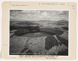
Didicas Volcano is an active volcanic island in the province of Cagayan in northern Philippines. The island, which was a submarine volcano and re-emerged from the sea in 1952, is 22 kilometres (14 mi) NE of Camiguin Island, one of the Babuyan Islands in Luzon Strait. Before 1952, the volcano first breached the ocean surface in 1857.

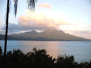
Taal Volcano is a large caldera filled by Taal Lake in the Philippines. Located in the province of Batangas about 50 kilometers (31 mi) south of Manila, the volcano is the second most active volcano in the country with 38 recorded historical eruptions, all of which were concentrated on Volcano Island, near the middle of Taal Lake. The caldera was formed by prehistoric eruptions between 140,000 and 5,380 BP.

Mount Bulusan, also known as Bulusan Volcano, is a stratovolcano on the island of Luzon in the Philippines. Located in the province of Sorsogon in the Bicol Region, it is 70 kilometres (43 mi) southeast of Mayon Volcano and approximately 390 kilometres (240 mi) southeast of Manila. Bulusan is one of the active volcanoes in the Philippines.

Babuyan Claro Volcano, also known as Mount Pangasun, is an active volcano located on Babuyan Island, the northernmost of the Babuyan group of islands in Luzon Strait, north of the main island of Luzon in the Philippines. It is classified as one of the active volcanoes of the country with the last confirmed eruption in 1860.
Kanlaon, also known as Mount Kanlaon and Kanlaon Volcano, is an active andesitic stratovolcano and the highest mountain on the island of Negros in the Philippines, as well as the highest peak in the Visayas, with an elevation of 2,465 m (8,087 ft) above sea level. Mount Kanlaon ranks as the 42nd-highest peak of an island in the world.
Camiguin de Babuyanes or Mount Camiguin, is an active stratovolcano on Camiguin Island which is part of the Babuyan Islands group that is located in Luzon Strait in the Philippines, north of the island of Luzon located in the municipality of Calayan in the province of Cagayan. The volcano and the island are within the jurisdiction of the municipality of Calayan, in the province of Cagayan. The island has a population of 5,231 people in 2020. There has been only one single eruption by the volcano prior to 1857.

Mount Hibok-Hibok is a stratovolcano on Camiguin Island in the Philippines. It is one of the active volcanoes in the country and part of the Pacific ring of fire.

Mount Iriga, also known as Mount Asog, is an active stratovolcano in the province of Camarines Sur, in the Philippines.

Mount Matutum is an active stratovolcano, is the highest point in the province of South Cotabato in the Philippines, with an elevation of 7,500 feet above sea level, approximately 5.7 kilometres (3.5 mi) from Acmonan, Tupi, South Cotabato. Matutum and its foothills are predominantly inhabited by indigenous Blaan families.

Musuan Peak or Mount Musuan, also known as Mount Calayo is an active volcano in Maramag, Bukidnon, on the island of Mindanao in the Philippines. It is 4.5 kilometres (2.8 mi) south of the city of Valencia, province of Bukidnon, and 81 kilometres (50 mi) southeast of Cagayan de Oro.

Smith Volcano, also known as Mount Babuyan, is a cinder cone on Babuyan Island, the northernmost of the Babuyan group of islands on Luzon Strait, north of the main island of Luzon in the Philippines. The mountain is one of the active volcanoes in the Philippines, which last erupted in 1924.

Mount Mélébingóy, formerly known as Parker Volcano, is an active volcano on Mindanao island in the Philippines. It is located in the province of South Cotabato, 30 km (19 mi) west of General Santos and 44 km (27 mi) south of Koronadal City.
Cabalian Volcano is an active stratovolcano located in the province of Southern Leyte in the Philippines.
Mount Mandalagan is a complex volcano located at latitude 10.65° North (10°39'0"N), longitude 123.25° East (123°15'0"E), in the province of Negros Occidental, on the north of the island of Negros of the Philippines. It is located inside the Northern Negros Natural Park.
Mount Natib is a dormant stratovolcano and caldera complex in the province of Bataan on western Luzon Island of the Philippines. The volcano complex occupies the northern portion of the Bataan Peninsula. The mountain and adjacent surrounding is a protected area first declared as the Bataan National Park in 1945.
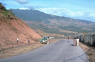
The Jolo Group of Volcanoes, more commonly referred to as the Jolo Group, are an active group of volcanoes in the island of Jolo in Southern Philippines. The Global Volcanism Program lists Jolo as one of the active volcanoes in the Philippines while the Philippine Institute of Volcanology and Seismology (PHIVOLCS) collectively list the group as Bud Dajo, one of the cinder cones on the island.
Balut Island, also known as Malulong, is a potentially active volcanic island south of the tip of Davao Occidental province in the Mindanao region, southern Philippines. At the center of the island is Balut Volcano, a fumarolic volcano with no historical eruptions.
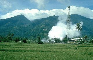
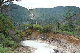
Mount Malinao is a potentially active stratovolcano located in the Bicol Region of the Philippines. The volcano displays strong fumarolic activity which is harnessed for generating electricity. Located on its slope is Tiwi Geothermal Power Plant, one of the first geothermal energy plant commissioned in the country.