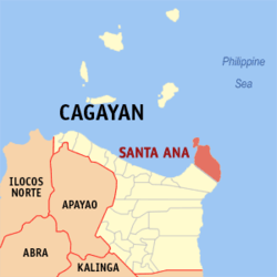
Santa Ana, officially the Municipality of Santa Ana (Ibanag: Ili nat Santa Ana; Ilocano: Ili ti Santa Ana; Tagalog: Bayan ng Santa Ana), is a municipality in the province of Cagayan, Philippines. According to the 2024 census, it has a population of 34,595 people.[5]
The first inhabitants of the region were Negritos and hacheros (woodcutters) under Don Julián Astigarraga (Capitán Vasco, 1854-1901[6]) of Aparri. Some fishermen from Minanga came and settled in Palawig. In 1891, Felipe Agarpao organized a gimong (society) called Inanama with some settlers. The purpose of the organization was to acquire and occupy land in the area. That same year, Briccio Campañano of Lapog, Ilocos Sur and others from Ilocos came to Palawig to apply for homesteads in the sitio of Marede. These settlers organized another gimong called Dagupan.[citation needed]
In 1900, the woodcutters from Aparri arrived by boat. The clearing of forests began shortly after.
From 1919 to 1935, several groups of settlers from the Ilocos Region came to claim territory aboard virays (light boats). The once-forested areas were only accessible via rivers and the sea. Before reaching settlements in the northern and eastern portions of the region, they had to navigate along the Palawig River.
The name Palawig was coined from the local term pasawig, meaning “river mouth”.[citation needed]
In 1935, the gimongs of Inanama and Dagupan were united into the polity of Da Inanama. Headed by Navarro, they began working for the secession of Palawig as a municipality independent of Gonzaga. Their application was held in abeyance because their population did not meet the minimum required by law. The proposal was later suspended in 1941 due to the Second World War .
After the war, Palawig and other neighboring barrios were eventually separated from Gonzaga, and the town was created by PresidentElpidio Quirino via Executive Order No. 289 on 21 October 1949. Contrary to the usual assumption, the town is not named for Saint Anne, mother of the Blessed Virgin Mary, but is an acronym of the surnames of the then-three provincial officials: Governor Nicasio Arranz and Provincial Board members Federico Navarro and Roberto Avena. The association with Saint Anne was a back-formation in keeping with the tradition of religious, Hispanic toponyms.[citation needed]
Santa Ana is situated 148.09 kilometres (92.02mi) from the provincial capital Tuguegarao, and 633.24 kilometres (393.48mi) from the country's capital city of Manila.
Barangays
Santa Ana is politically subdivided into 16 barangays.[7] Each barangay consists of puroks while some have sitios. The town is divided into two sections by the Palawig River, east and west.
Batu-Parada
Casagan
Casambalangan (Port Irene)
Centro (Poblacion)
Diora-Zinungan
Dungeg
Kapanikian
Marede
Palawig
Patunungan
Rapuli (Punti)
San Vicente (Fort)
Santa Clara
Santa Cruz
Tangatan
Visitacion (Poblacion)
Climate
Santa Ana has a tropical monsoon climate (Am according to the Köppen climate classification) with hot, humid conditions prevailing year round. The average annual high temperature is 28°C (82°F) and the average annual low temperature is 23°C (73°F). Santa Ana receives 1,818 millimetres (71.6in) of precipitation annually.
In the 2024 census, the population of Santa Ana was 34,595 people,[14] with a population density of 78 inhabitants per square kilometre or 200 inhabitants per square mile.
Some of its agricultural and aquatic products are rice, corn, peanut, fish, lumber, shells, etc. Among its natural resources are limestone deposits at Bawac Mountain, coal at Carbon Mountain, Santa Clara and guano deposits in Kapannikian Cave.
Tourism
The Pacific Ocean from top of Cape Engaño Lighthouse, Palaui Island
Aside from the Cagayan Special Economic Zone, which hosts casinos and other gaming facilities, Santa Ana has other scenic spots and historical landmarks. These include:
Buwacag Falls at Santa Clara (open for public), Padlas Falls at Casambalangan, and Lamesa Falls at Casagan (not yet ready for public)[citation needed]
Dumasag River at Rapuli
Takuli riding (a traditional kayak) and firefly watching at Barangay Casagan
Belt Fishing at Diora-Zinungan
Santa Ana is the game fishing hub of the Philippines. It has hosted international decathlons, where athletes run the rugged terrain of Punta Verde to Cape Engaño, then swim in the Philippine Sea.
Santa Ana is part of the first legislative district of the province of Cagayan. It is governed by a mayor, designated as its local chief executive, and by a municipal council as its legislative body in accordance with the Local Government Code. The mayor, vice mayor, and the municipal councilors are elected directly by the people through elections held every three years.
The Schools Division of Cagayan governs the town's public education system.[24] The division office is a field office of the Philippine Department of Education in the Cagayan Valley region.[25] The Sta. Ana Schools District Office governs the public and private elementary and high schools throughout the municipality.[26] These include schools with culturally integrated curricula for Indigenous Aeta students.
Primary and elementary schools
Apolagan Elementary School
Casagan Elementary School
Casambalangan Elementary School
Diora-Zinungan Elementary School
Dungeg Elementary School
Kapanikian Elementary School
Marede Elementary School
Pagadalan Dagiti Agta iti Sta Ana Cagayan Association (PAG-ASACA) - Bantay Balligi
Pagadalan Dagiti Agta iti Sta Ana Cagayan Association (PAG-ASACA) - Domasag
Pagadalan Dagiti Agta iti Sta Ana Cagayan Association (PAG-ASACA) - Palaui
Palaui Elementary School
Palawig Elementary School
Pananacpan Elementary School
Pasmakanan Elementary School
Patunungan Elementary School
Racat Elementary School
Rapuli Elementary School
RJ Dama Christian Academy
San Vicente Elementary School
St. Anthony's College (Elementary School)
Sta. Ana Central School
Sta. Clara Elementary School
Tangatan Elementary School
The Promised Land Christian School of Santa Ana
Top Achievers Private School (Elementary School)
Visitacion Elementary School
Secondary schools
Casambalangan National High School
Sta. Ana Fishery National High School
St. Anthony's College (High School)
Top Achievers Private School (High School)
Higher educational institution
St. Anthony's College
Culture
Every year from May 26 to May 30, the town hosts the Viray Festival, organized by the local government with the support of the regional tourism office and the private sector. Launched in June 2005, the Viray Festival was conceived to dramatize the significance of the viray, which played a key role in the lives and history of the town.[citation needed]
A viray is a large, flat wooden boat which, before the emergence of gasoline-fed engines in the early 1950s, was propelled by sails. Traders used large virays measuring 18 metres (59ft) long, 5 metres (16ft) wide and 3.5 metres (11ft) high. Fishermen, on the other hand, used smaller ones, usually 11 metres (36ft) long, 5 metres (16ft) wide and 2.5 metres (8ft 2in) high. Equipped with oars to reach nearby fishing grounds, these types sailed for longer distances.[citation needed]
Due to its capacity to carry great quantities of cargo, the viray was the only means of transport used by the first settlers of Santa Ana.
Leaders and well-off families gained income from the services of the viray, ranging from fishing, commerce and trading to means of transport during the years when Santa Ana was in its prime.[clarification needed] They used the viray for fishing, as the boats could carry fishing gear, provisions, supplies, and people. It was assisted by small bancas during fishing operations.
An annual fluvial parade of colorful boats is held during the first day. The second day of the festival features a grand carabao parade where each of the sixteen barangays composing the municipality take their turn to show off their artistic talents. On the third day, both locals and visitors line up along the main street to watch people participating in the street dancing competition.
Sports
Santa Ana is also known for kiteboarding and windsurfing. In 2015, the Philippine Windsurfing Association and the Philippine Kiteboarding Association organized a competition off Anguib Beach.[27]
This page is based on this Wikipedia article Text is available under the CC BY-SA 4.0 license; additional terms may apply. Images, videos and audio are available under their respective licenses.