Mount Biliran is a solfataric active complex volcano located in the island province of Biliran in the Philippines. The volcano caused the formation of the island.
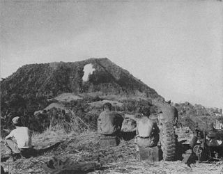
Bud Dajo, is a cinder cone and the second highest point (+600m) in Sulu, a province of the Philippines in the Sulu Archipelago. It is one of the cinder cones that make up the island of Jolo and part of the Jolo Volcanic Group. The extinct volcano is located 8 kilometres (5.0 mi) southeast from the town of Jolo in Sulu. The mountain and adjacent lands were declared as Mount Dajo National Park in 1938. It is a sacred mountain for the locals, and the Tausug people at-large, as well as nearby ethnic groups.

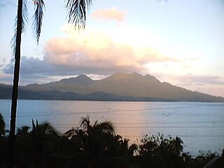
Taal Volcano is a large caldera filled by Taal Lake in the Philippines. Located in the province of Batangas about 50 kilometers (31 mi) south of Manila, the volcano is the second most active volcano in the country with 38 recorded historical eruptions, all of which were concentrated on Volcano Island, near the middle of Taal Lake. The caldera was formed by prehistoric eruptions between 140,000 and 5,380 BP.

Babuyan Claro Volcano, also known as Mount Pangasun, is an active volcano located on Babuyan Island, the northernmost of the Babuyan group of islands in Luzon Strait, north of the main island of Luzon in the Philippines. It is classified as one of the active volcanoes of the country with the last confirmed eruption in 1860.

Cagua Volcano is a stratovolcano located in the Philippine province of Cagayan. It is one of the active volcanoes in the Philippines and has erupted twice in recorded history. Its last eruption was in 1907.
Kanlaon, also known as Mount Kanlaon and Kanlaon Volcano, is an active andesitic stratovolcano and the highest mountain on the island of Negros in the Philippines, as well as the highest peak in the Visayas, with an elevation of 2,465 m (8,087 ft) above sea level. Mount Kanlaon ranks as the 42nd-highest peak of an island in the world.

Mount Hibok-Hibok is a stratovolcano on Camiguin Island in the Philippines. One of the active volcanoes in the country, it is part of the Pacific ring of fire.

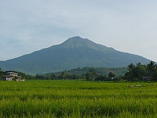
Mount Matutum is an active stratovolcano, is the highest point in the province of South Cotabato in the Philippines, with an elevation of 7,500 feet above sea level, approximately 5.7 kilometres (3.5 mi) from Acmonan, Tupi, South Cotabato. Matutum and its foothills are predominantly inhabited by indigenous Blaan families.

Mount Mélébingóy, formerly known as Parker Volcano, is an active volcano on Mindanao island in the Philippines. It is located in the province of South Cotabato, 30 km (19 mi) west of General Santos and 44 km (27 mi) south of Koronadal City.
Mount Leonard Kniaseff, or simply Leonard Kniaseff, is a stratovolcano between the municipalities of Mabini and Maco in the province of Davao de Oro, island of Mindanao, Philippines.

Mount Talinis is a complex volcano in the Philippine province of Negros Oriental. At about 1,862 metres (6,109 ft) above sea level, it is the second highest mountain on Negros Island after Mount Kanlaon, and the tallest peak in the mountain range known as the Cuernos de Negros. The volcano is located 9 km (5.6 mi) southwest of the municipality of Valencia; and 20 km (12 mi) from Dumaguete, the capital of the province.

Mount Malindang is a complex volcano located in the province of Misamis Occidental in the southern island of Mindanao, Philippines. It is the highest point in the province. The least studied mountain range was formed through several volcanic activities some of which could be historical, evident by the presence of two calderas, surrounded by high rock walls, cinder cones, dome volcano plugs, two sulfurous hot springs, and a crater lake named Lake Duminagat. The amphitheater structures have extensive distribution of volcanic rocks, carbonized wood that are found in pyroclastic deposits. The mountain range is dissected by several canyons and ravines.
Cabalian Volcano is an active stratovolcano located in the province of Southern Leyte in the Philippines.
Mount Mandalagan is a complex volcano located at latitude 10.65° North (10°39'0"N), longitude 123.25° East (123°15'0"E), in the province of Negros Occidental, on the north of the island of Negros of the Philippines. It is located inside the Northern Negros Natural Park.

Mount Santo Tomas is a potentially active stratovolcano in the Philippines located in the municipality of Tuba in the province of Benguet. The mountain is part of the protected Santo Tomas Forest Reserve declared through Proclamation No. 581 signed by President Manuel L. Quezon on July 9, 1940.
Mount Labo, is a potentially active stratovolcano in the province of Camarines Norte, in the Bicol Region (Region V), on Luzon Island, in the Philippines. It is located at the northwest end of the Bicol Peninsula.

Mount Balatukan is a massive potentially active compound stratovolcano in the Southern island of Mindanao, Philippines. It is the highest point in the province of Misamis Oriental. The volcano has no historical eruptions but displays fumarolic activity. The 2,450-metre (8,040 ft) mountain is topped by a triangular shaped caldera 15 kilometers (9.3 mi) long and 10.6 kilometers (6.6 mi) at its widest. The Balatocan River emanates from and drains the huge crater.
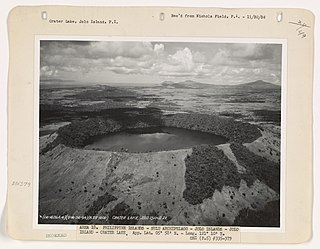
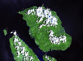
The Jolo Group of Volcanoes, more commonly referred to as the Jolo Group, are an active group of volcanoes on the island of Jolo in Southern Philippines. The Global Volcanism Program lists Jolo as one of the active volcanoes in the Philippines while the Philippine Institute of Volcanology and Seismology (PHIVOLCS) collectively lists the group as Bud Dajo, one of the cinder cones on the island.
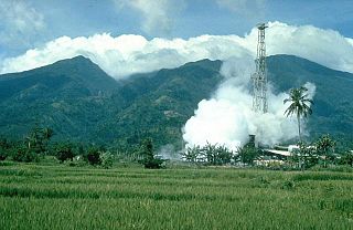
Mount Malinao is a potentially active stratovolcano located in the Bicol Region of the Philippines. The volcano displays strong fumarolic activity which is harnessed for generating electricity. Located on its slope is Tiwi Geothermal Power Plant, one of the first geothermal energy plant commissioned in the country.


