Mudpot

Last updated
Mudpot in Lassen Volcanic National Park
Mudpots lined up above a volcanic fissure at Hverarond, Iceland Mudpots at Hverarond.jpg
Mudpots lined up above a volcanic fissure at Hverarönd, Iceland

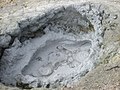
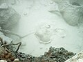
A mudpot, or mud pool, is a type of acidic hot spring, or fumarole, with limited water. It usually takes the form of a pool of bubbling mud, as a result of the acid and microorganisms decomposing surrounding rock into clay and mud.

Contents

Description

The mud of a mudpot takes the form of a viscous, often bubbling, slurry. As the boiling mud is often squirted over the brims of the mudpot, a form resembling a mini-volcano of mud starts to build up, sometimes reaching heights of 1 to 1.5 m (3+12 to 5 ft). [1] Although mudpots are often called "mud volcanoes", true mud volcanoes are very different in nature. The mud of a mudpot is generally of white to greyish color, but is sometimes stained with reddish or pink spots from iron compounds. When the slurry is particularly colorful, the feature may be referred to as a paint pot. [2]

Geology

Mudpots form in high-temperature geothermal areas where water is in short supply. The little water that is available rises to the surface at a spot where the soil is rich in volcanic ash, clay, and other fine particulates. The thickness of the mud usually changes along with seasonal changes in the water table. [3] [4]

Notable sites

The geothermal areas of Yellowstone National Park contain several notable examples of both mudpots and paint pots, as do some areas of Azerbaijan, Iceland, New Zealand and Nicaragua.

Several locations in and around the Salton Sea in California are also home to active mudpots, [5] including the moving Niland Geyser. [6] [7] In the case of Niland Geyser, its name is somewhat of a misnomer, as the release of carbon dioxide by seismic activity from the nearby San Andreas Fault is responsible for its behaviour, rather than through geothermal activity. The fluid contained within it is near background temperature rather than boiling, measuring around 27 °C (80 °F). [8]

Related Research Articles

<span class="mw-page-title-main">Geyser</span> Natural explosive eruption of hot water

A geyser is a spring characterized by an intermittent discharge of water ejected turbulently and accompanied by steam. As a fairly rare phenomenon, the formation of geysers is due to particular hydrogeological conditions that exist only in a few places on Earth.

<span class="mw-page-title-main">Fumarole</span> Volcanic opening that emits hot gases

A fumarole is a vent in the surface of the Earth or another rocky planet from which hot volcanic gases and vapors are emitted, without any accompanying liquids or solids. Fumaroles are characteristic of the late stages of volcanic activity, but fumarole activity can also precede a volcanic eruption and has been used for eruption prediction. Most fumaroles die down within a few days or weeks of the end of an eruption, but a few are persistent, lasting for decades or longer. An area containing fumaroles is known as a fumarole field.

<span class="mw-page-title-main">Geothermal areas of Yellowstone</span> Geyser basins and other geothermal features in Yellowstone National Park

The geothermal areas of Yellowstone include several geyser basins in Yellowstone National Park as well as other geothermal features such as hot springs, mud pots, and fumaroles. The number of thermal features in Yellowstone is estimated at 10,000. A study that was completed in 2011 found that a total of 1,283 geysers have erupted in Yellowstone, 465 of which are active during an average year. These are distributed among nine geyser basins, with a few geysers found in smaller thermal areas throughout the Park. The number of geysers in each geyser basin are as follows: Upper Geyser Basin (410), Midway Geyser Basin (59), Lower Geyser Basin (283), Norris Geyser Basin (193), West Thumb Geyser Basin (84), Gibbon Geyser Basin (24), Lone Star Geyser Basin (21), Shoshone Geyser Basin (107), Heart Lake Geyser Basin (69), other areas (33). Although famous large geysers like Old Faithful are part of the total, most of Yellowstone's geysers are small, erupting to only a foot or two. The hydrothermal system that supplies the geysers with hot water sits within an ancient active caldera. Many of the thermal features in Yellowstone build up sinter, geyserite, or travertine deposits around and within them.

<span class="mw-page-title-main">Geothermal areas in Lassen Volcanic National Park</span>

The geothermal areas in Lassen Volcanic National Park include several groups of hot springs and fumaroles, as remnants of former volcanic activity, exist in Lassen Volcanic National Park in northeastern California. Most of these lie in or are closely adjacent to Mount Tehama's caldera. Bumpass Hell is the most spectacular of these, but others of importance are Sulphur Works, Little Hot Springs Valley, Boiling Springs Lake and Devil's Kitchen. In each thermal area, the highest temperature of water generally is close to the boiling temperature at the altitude of the particular spring or fumarole — 198 °F (92 °C) at Bumpass Hell and 191 °F (88 °C) on the northwest flanks of Lassen Peak. Temperatures as high as 230 °F (110 °C) have been recorded in the park.

<span class="mw-page-title-main">Yellowstone Caldera</span> Volcanic caldera in Yellowstone National Park in the United states

The Yellowstone Caldera, sometimes referred to as the Yellowstone Supervolcano, is a volcanic caldera and supervolcano in Yellowstone National Park in the Western United States. The caldera and most of the park are located in the northwest corner of the state of Wyoming. The caldera measures 43 by 28 miles, and postcaldera lavas spill out a significant distance beyond the caldera proper.

<span class="mw-page-title-main">El Tatio</span> Geyser field located in the Andes Mountains, Chile

El Tatio is a geothermal field with many geysers located in the Andes Mountains of northern Chile at 4,320 metres (14,170 ft) above mean sea level. It is the third-largest geyser field in the world and the largest in the Southern Hemisphere. Various meanings have been proposed for the name "El Tatio", including "oven" or "grandfather". The geothermal field has many geysers, hot springs, and associated sinter deposits. These hot springs eventually form the Rio Salado, a major tributary of the Rio Loa, and are a major source of arsenic pollution in the river. The vents are sites of populations of extremophile microorganisms such as hyperthermophiles, and El Tatio has been studied as an analogue for the early Earth and possible past life on Mars.

<span class="mw-page-title-main">Imperial Valley</span> Valley in California, United States

The Imperial Valley of Southern California lies in Imperial and Riverside counties, with an urban area centered on the city of El Centro. The Valley is bordered by the Colorado River to the east and, in part, the Salton Sea to the west. Farther west lies the San Diego and Imperial County border. To the north is the Coachella Valley region of Riverside County, which together with Imperial Valley form the Salton Trough, or the Cahuilla Basin, also the county line of Imperial and Riverside counties, and to the south the international boundary with Mexico.

<span class="mw-page-title-main">Mud volcano</span> Landform created by the eruption of mud or slurries, water and gases

A mud volcano or mud dome is a landform created by the eruption of mud or slurries, water and gases. Several geological processes may cause the formation of mud volcanoes. Mud volcanoes are not true igneous volcanoes as they do not produce lava and are not necessarily driven by magmatic activity. Mud volcanoes may range in size from merely 1 or 2 meters high and 1 or 2 meters wide, to 700 meters high and 10 kilometers wide. Smaller mud exudations are sometimes referred to as mud-pots.

<span class="mw-page-title-main">Fountain Paint Pot</span> Mud pot located in Lower Geyser Basin in Yellowstone National Park

The Fountain Paint Pot is a mud pot located in Lower Geyser Basin in Yellowstone National Park.

<span class="mw-page-title-main">Grand Prismatic Spring</span> Largest hot spring in the United States

The Grand Prismatic Spring in Yellowstone National Park is the largest hot spring in the United States, and the third largest in the world, after Frying Pan Lake in New Zealand and Boiling Lake in Dominica. It is located in the Midway Geyser Basin.

<span class="mw-page-title-main">Artemisia Geyser</span>

Artemisia Geyser is a geyser in the Upper Geyser Basin of Yellowstone National Park in the United States.

<span class="mw-page-title-main">Orakei Korako</span>

Orakei Korako is a highly active geothermal area most notable for its series of fault-stepped sinter terraces, located in a valley north of Taupō on the banks of the Waikato River in the Taupō Volcanic Zone, New Zealand. It is also known as "The Hidden Valley".

<span class="mw-page-title-main">Fishing Cone</span> Geyser in Yellowstone National Park

Fishing Cone, also known as Fishing Pot Hot Springs is a geyser in the West Thumb Geyser Basin of Yellowstone National Park in Wyoming - America.

Hydrothermal explosions occur when superheated water trapped below the surface of the Earth rapidly converts from liquid to steam, violently disrupting the confining rock. Boiling water, steam, mud, and rock fragments are ejected over an area of a few meters up to several kilometers in diameter. Although the energy originally comes from a deep igneous source, this energy is transferred to the surface by circulating meteoric water or mixtures of meteoric and magmatic water rather than by magma, as occurs in volcanic eruptions. The energy is stored as heat in hot water and rock within a few hundred feet of the surface.

<span class="mw-page-title-main">Tikitere</span> Rural settlement in Bay of Plenty Region, New Zealand

Tikitere, also known as "Hell's Gate", is a suburb in Rotorua's most active geothermal area on State Highway 30, between Lake Rotorua and Lake Rotoiti in the Bay of Plenty, New Zealand. It includes many geothermal features such as steaming lakes, mudpools, fumaroles, a mud volcano and the Kakahi Falls, the largest hot waterfall in the southern hemisphere.

<span class="mw-page-title-main">Salton Trough</span> Active tectonic pull-apart basin in California, United States and Baja California, Mexico

The Salton Trough is an active tectonic pull-apart basin, or graben. It lies within the Imperial, Riverside, and San Diego counties of southeastern California and extends south of the Mexico–United States border into the state of Baja California.

The Salton Buttes are a group of volcanoes in Southern California, on the Salton Sea. They consist of a 7-kilometer (4.3 mi)-long row of five lava domes, named Mullet Island, North Red Hill, Obsidian Butte, Rock Hill and South Red Hill. They are closely associated with a fumarolic field and a geothermal field, and there is evidence of buried volcanoes underground. In pre-modern times Obsidian Butte was an important regional source of obsidian.

<span class="mw-page-title-main">Black Sand Basin Hot Springs</span> Thermal springs

Black Sand Basin is one of a grouping of geothermal hot springs and geysers located in the Upper Geyser Basin of Yellowstone National Park, Wyoming. The spring is too hot to use as a mineral bath as its scalding 200 °F (93 °C) or hotter water has proven to be fatal. In the winter, a marked ski trail runs from the Old Faithful Visitor Center to Black Sand Basin

<span class="mw-page-title-main">Niland Geyser</span> Moving mud pot near Niland, California

Niland Geyser is a moving mud pot or mud spring outside Niland, California in the Salton Trough in an area of geological instability due to the San Andreas fault, formed due to carbon dioxide being released underground. It is the only mud pot or mud volcano known to have moved so significantly. The geyser has required costly engineering works since 2018 as it has impinged on the Union Pacific Railroad, California State Route 111, and other infrastructure.

<span class="mw-page-title-main">Geothermal activity</span> Activity resulting from underground heat

Geothermal activity is a group of natural heat transfer processes, occurring on Earth's surface, caused by the presence of excess heat in the subsurface of the affected area. Geothermal activity can manifest itself in a variety of different phenomena, including, among others, elevated surface temperatures, various forms of hydrothermal activity, and the presence of fumaroles that emit hot volcanic gases.

References

  1. Kleinschmidt, Janice (28 February 2006). "Sea of Wonders". Palms Springs Life. Retrieved 21 January 2017.
  2. Chilton (1916). "Death Valley Dodge with O.K. Parker st the Wheel". Motor Agr. Retrieved 21 January 2017.
  3. "Mudpots - Old Faithful Virtual Visitor Center". www.nps.gov. Retrieved 2023-04-21.
  4. Lynch, D. K.; Hudnut, K. W. (2008-08-01). "The Wister Mud Pot Lineament: Southeastward Extension or Abandoned Strand of the San Andreas Fault?" (PDF). Bulletin of the Seismological Society of America. 98 (4): 1720–1729. Bibcode:2008BuSSA..98.1720L. doi:10.1785/0120070252. ISSN   0037-1106.
  5. Laflin, Patricia B. "The Salton Sea: California;s Overlooked Treasure — Chapter 8 — Mudpots, Geysers and Mullet Island". San Diego State University. Retrieved 21 January 2017.
  6. Francuch, Dean G; Deane, Travis; Zamora, Carol (2019). "The meandering Mundo Mud Pot: Or how Salton Sea tectonics affect international trade". Proceedings of the 70th Highway Geology Symposium: 439-456.
  7. Andrews, Robin George (November 9, 2018). "A bubbling pool of mud is on the move, and no one knows why". National Geographic. Archived from the original on February 25, 2021.
  8. "A San Andreas fault mystery: The 'slow-moving disaster' in an area where the Big One is feared". Los Angeles Times. 2018-11-01. Retrieved 2022-10-14.