
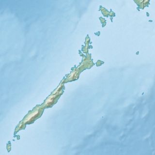
Leyte Gulf is a gulf in the Eastern Visayan region in the Philippines. The bay is part of the Philippine Sea of the Pacific Ocean, and is bounded by two islands; Samar in the north and Leyte in the west. On the south of the bay is Mindanao Island, separated from Leyte by the Surigao Strait. Dinagat Island partly encloses the gulf to the southeast, and the small Homonhon Island and Suluan Island, sit astride the eastern entrance to the Gulf. It is approximately 130 km (81 mi) north-south, and 60 km (37 mi) east-west.
Eastern Samar is a province in the Philippines located in the Eastern Visayas region. Its capital is the city of Borongan. Eastern Samar occupies the eastern portion of the island of Samar. Bordering the province to the north is the province of Northern Samar and to the west is Samar province. To the east lies the Philippine Sea, part of the vast Pacific Ocean, while to the south lies the Leyte Gulf.

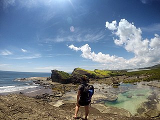
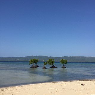
Homonhon Island is an island in the province of Eastern Samar, Philippines, on the east side of Leyte Gulf. The 20-kilometre (12 mi) long island is part of the municipality of Guiuan, encompassing eight barangays: Bitaugan, Cagusu-an, Canawayon, Casuguran, Culasi, Habag, Inapulangan, and Pagbabangnan.

Samar is the third largest island in the Philippines. Located in eastern Visayas, within central Philippines. The island is divided into three provinces: Samar, Northern Samar, and Eastern Samar. These three provinces, along with the provinces on the nearby islands of Leyte and Biliran are part of the Eastern Visayas region.
Biri, officially the Municipality of Biri, is a 5th class municipality in the province of Northern Samar, Philippines. According to the 2015 census, it has a population of 11,767 people.

Guiuan, officially the Municipality of Guiuan, is a 2nd class municipality in the province of Eastern Samar, Philippines. According to the 2015 census, it has a population of 52,991 people.
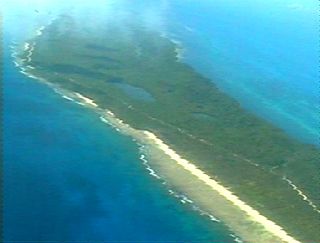
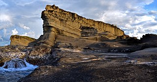
Suluan is an island barangay in the Philippines, in the municipality of Guiuan, Eastern Samar. It lies east of Leyte Gulf and west of Emden Deep. The island was deemed to be the first site of anchorage for Ferdinand Magellan's Spanish Armada.
Calicoan is a Philippine island east of Leyte Gulf, off the southeastern point of Samar. It is one of the islands that are part of the municipality of Guiuan, in the province of Eastern Samar. The island can be reached from Tacloban City by a two-hour bus ride.
Lagonoy Gulf is a large gulf in the Bicol Peninsula of Luzon island in the Philippines. It is separated from the Philippine Sea by the Caramoan Peninsula in the north; and is separated from Albay Gulf in the south by a chain of islands including Batan Island and Rapu-rapu Island. It is about 3,070 square kilometres (1,190 sq mi) in area, with 80% of its area between 800 metres (2,600 ft) and 1,200 metres (3,900 ft) deep.

The Olango Island Group is a group of islands found in the Central Visayas region of the Philippines and is a part of Cebu Province. It comprises Olango island and 6 satellite islets namely: Sulpa, Gilutongan, Nalusuan, Caohagan, Pangan-an, and Camungi. Olango Island and its neighboring islets has a total land area of approximately 1,030 ha. The island group is divided under the jurisdiction of the city of Lapu-Lapu and the municipality of Cordova. It lies 5 km (3.1 mi) east of Mactan Island and is a major tourist destination in Cebu. It is known for its wildlife sanctuary. The entire area is the first declared Ramsar Wetland Site in the Philippines, as recognized in 1994.

Danajon Islet, also known as Dawahon Islet, is an islet in the Philippines found at the easternmost end of the Danajon Bank. The islet is coterminous with Barangay Dawahon, which is under the jurisdiction of the municipality of Bato in the province of Leyte. The islet is only 5 hectares, and has a population of about 10,000, depending on the time of year. The islet is only 3 meters above sea level, but the Danajon Bank protects it somewhat.

The Danajon Bank is the only double barrier reef in the Philippines, which is a very rare geological formation, which is located in the Camotes Sea. It comprises two sets of large coral reefs that formed offshore on a submarine ridge due to a combination of favorable tidal currents and coral growth in the area.

Pujada Bay, sometimes called Pujaga Bay, is a bay on the Pacific coast of the southern Philippine island of Mindanao. It is an arm of the Philippine Sea in Davao Oriental province formed by the Guanguan Peninsula which separates it from the Mayo Bay on the east and the Pujada Peninsula which separates it from the Davao Gulf on the west. Pujada Bay borders Mati, the province's capital and largest city, with its port and city proper situated at its head. It is entered between Lamigan Point on the east and Tumago Point on the west, with the Pujada Island dividing its entrance into two channels. There are three other islands on the bay, namely Uanivan, Oak and Ivy islands.
Malampaya Sound is a protected inlet of the South China Sea on the northwestern coast of Palawan Island in western Philippines. It is a geographic sound consisting of a complex of sheltered bays, coves, estuaries and islands separated from the sea to the west by the Copoas Peninsula. The sound is within the municipality of Taytay and is an important feature for the ecology and economy of the province of Palawan. It is considered one of the finest natural harbors in the Philippines and one of Palawan's richest fishing grounds.
Alibijaban is a small island located off the southeastern coast of Bondoc Peninsula in the Philippines. It belongs administratively to the municipality of San Andres, Quezon province, and is coterminous with the barangay of the same name. With a population of 1,643 inhabitants in 2015, it is the smallest of seven barangays in San Andres.
Malabungot, alternatively spelled as Malabungut, and also known as Mahad, is an island in Binagasbasan Bay off the coast of Garchitorena in Camarines Sur, Philippines. It is separated from Caramoan Peninsula in the south by the Quinalasag Passage, also known as Sisiran Passage, which connects Lamit and Sisiran bays. The island forms the head of Binagasbasan Bay, bordered to the west by the Lamit Islands and to the east by Quinalasag Island, and which opens northward to the Philippine Sea. It is designated as a protected landscape and seascape on account of its biodiversity and ecological significance.
The Mabini Protected Landscape and Seascape, in Davao de Oro, Philippines, is a terrestrial and marine protected area established in 2000 to protect ecologically significant habitats in the Davao Gulf. The park extends along the coast of the municipality of Mabini from the mouth of the Pandasan River to the southern tip of Kopiat Island. It also includes Lunod Island, also known as Pandasan Island, which was earlier declared a wilderness area in 1981. It covers 6,106 hectares of extensive mangrove forests, white sand beaches and rich coral reef systems.
The Biri Larosa Protected Landscape and Seascape is a protected area located in Northern Samar, Philippines, about 40 kilometres (25 mi) west of Catarman. It protects the Balicuatro Islands, composed of the island municipality of Biri and associated smaller islands, off the northwestern coast of Samar in the San Bernardino Strait. It also includes the coastal areas of the adjacent municipalities from which it derives the second half of its name – a combination of the first two letters of Lavezares, Rosario and San Jose.

Burias Pass is the strait that separates Burias Island from the Bicol Peninsula in the Philippines. It connects the Ragay Gulf in the north with the Ticao Pass and Samar Sea in the south. It is considered a very important biodiversity area of the country.
The East African coral coast is a marine ecoregion along the eastern coast of Africa. It extends along the coasts of Kenya, Tanzania, and northern Mozambique, from Lamu in Kenya to Angoche in Mozambique. It adjoins the Northern Monsoon Current Coast ecoregion to the north, and the Bight of Sofala/Swamp Coast ecoregion to the south.


