Leyte Gulf, also known simply as the Leyte, is a gulf in the Eastern Visayan region in the Philippines. The bay is part of the Philippine Sea of the Pacific Ocean, and is bounded by two islands; Samar in the north and Leyte in the west. On the south of the bay is Mindanao Island, separated from Leyte by the Surigao Strait. Dinagat Island partly encloses the gulf to the southeast, and the small Homonhon Island and Suluan Island, sit astride the eastern entrance to the Gulf. It is approximately 130 km (81 mi) north-south, and 60 km (37 mi) east-west.

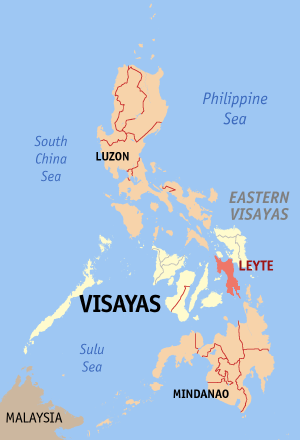
Leyte, officially the Province of Leyte, is a province in the Philippines located in the Eastern Visayas region occupying the northern three-quarters of Leyte Island. Its capital and largest city is Tacloban, administered independently from the province. Leyte is thus north of Southern Leyte, south of Biliran, and west of Samar Island. To the west across the Camotes Sea is the province of Cebu.

Biliran, officially the Province of Biliran, is an island province in the Philippines located in the Eastern Visayas region. Biliran is one of the country's smallest and newest provinces. Formerly a sub-province of Leyte, it became an independent province in 1992.
Northern Samar, officially the Province of Northern Samar, is a province in the Philippines located in the Eastern Visayas region. Its capital is Catarman and is located at the northern portion of the island of Samar. Bordering the province to the south are the provinces of Samar and Eastern Samar. To the northwest, across the San Bernardino Strait is Sorsogon; to the east is the Philippine Sea of the Pacific Ocean and to the west is Samar Sea.

Eastern Samar, officially the Province of Eastern Samar, is a province in the Philippines located in the Eastern Visayas region. Its capital is the city of Borongan. Eastern Samar occupies the eastern portion of the island of Samar. Bordering the province to the north is the province of Northern Samar and to the west is Samar province. To the east lies the Philippine Sea, part of the vast Pacific Ocean, while to the south lies Leyte Gulf.

Samar, officially the Province of Samar, formerly named Western Samar, is a province in the Philippines located in the Eastern Visayas region. Its capital is the city of Catbalogan. It is bordered by Northern Samar, Eastern Samar, Leyte and Leyte Gulf, and includes several islands in the Samar Sea. Samar is connected to the island of Leyte via the San Juanico Bridge.

Tacloban, officially the City of Tacloban, is a highly urbanized city on Leyte island in the Eastern Visayas region of the Philippines. According to the 2020 census, Tacloban has a population of 251,881, making it the most populous city in the Eastern Visayas. The city is located 360 miles (580 km) southeast from Manila.

San Antonio, officially the Municipality of San Antonio, is a 5th class municipality in the province of Northern Samar, Philippines. According to the 2020 census, it has a population of 8,882 people.
Borongan, officially the City of Borongan, is a 1st class component city and capital of the province of Eastern Samar, Philippines. According to the 2020 census, it has a population of 71,961 people.
Guiuan, officially the Municipality of Guiuan, is a 2nd class municipality in the province of Eastern Samar, Philippines. It constitutes the southeastern extremity of Samar Island and some adjacent islands, surrounded by Leyte Gulf and the Philippine Sea, two major bodies of water that makes the town the surfing capital of the Visayas. According to the 2020 census, it has a population of 53,361 people, making it the most populous municipality in Eastern Samar and the second most populous administrative division in the entire province after the capital city Borongan.

Lawaan, officially the Municipality of Lawaan, is a 5th class municipality in the province of Eastern Samar, Philippines. According to the 2020 census, it has a population of 13,003 people. It is home to Bolusao Watershed Forest Reserve, primarily located in Barangay Bolusao.
The super regions of the Philippines are an informal and de facto defunct grouping of parts of regions and provinces of the Philippines based on their economic strengths. According to Executive Order No. 561, which establishes these regions,
"[These] groupings neither supersede current political boundaries nor alter the regional development councils as established by existing laws and issuances."
Guiuan Airport is an airport located in the municipality of Guiuan, in the province of Eastern Samar in the Philippines. It is classified as a feeder airport by the Civil Aviation Authority of the Philippines, an attached agency of the Department of Transportation that is responsible for the operations all airports in the Philippines, except the major international airports.

The Immaculate Conception Parish Church, commonly known as Guiuan Church, is a Roman Catholic church in the municipality of Guiuan, Eastern Samar, Philippines, within the jurisdiction of the Diocese of Borongan.
Eastern Visayas is an administrative region in the Philippines, designated as Region VIII. It consists of three main islands: Samar, Leyte, and Biliran. The region has six provinces: Biliran, Leyte, Northern Samar, Samar, Eastern Samar, Southern Leyte, one independent city, Ormoc, and one highly urbanized city, Tacloban. The highly urbanized city of Tacloban is the sole regional center. These provinces and cities occupy the easternmost islands of the Visayas group of islands, hence the region's name.

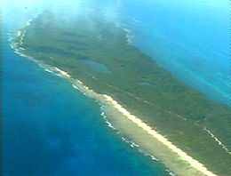
The Guiuan Protected Landscape and Seascape, also known as the Guiuan Marine Reserve, is a protected area associated with the Guiuan Island Group which is located off the coast of the municipality of Guiuan on the eastern side of Leyte Gulf in the Philippines. The protected area consists of the following islands from within the group: Calicoan, Manicani, Suluan, Tubabao, Victory, Homonhon and other smaller islands and their surrounding reefs. It also includes the coastal area of mainland Guiuan in Eastern Samar covering a total area of 60,448 hectares. The land which now comprises the conservation area was previously declared as a Marine Reserve and Tourist Zone and was placed under the administration and control of the Philippine Tourism Authority in 1978. It was re-proclaimed and re-classified as a protected landscape/seascape in 1994 under the National Integrated Protected Areas System Act of 1992.
The COVID-19 pandemic in Eastern Visayas is part of the worldwide pandemic of coronavirus disease 2019 caused by severe acute respiratory syndrome coronavirus 2. The virus reached Eastern Visayas on March 23, 2020, when the first case of the disease was confirmed in Northern Samar.

The Mindanao–Eastern Visayas rain forests ecoregion covers the lowland rain forests of the island of Mindanao and of the easternmost of the Visayas Islands in the Philippines. Although 63% of this ecoregion is covered with closed broadleaf evergreen forest or open forest, much of this has been disturbed in the past by human activity, and many of the rare species of the area have been relegated to the isolated areas or higher elevations.
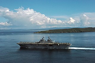
Leyte–Samar Naval Base was a large United States Navy base in the Philippines on the Islands of Leyte, Samar and the San Pedro Bay. The base was built during World War II to support the many naval ships fighting and patrolling in the South West Pacific theatre of war as part of the Pacific War. A number of naval facilities were built on the east coast of Leyte island starting October 20, 1944. The first base was built at between the city of Tacloban and Anibong Point, a mile north of the city. Headquarters for the Seventh Fleet was built at Tolosa, 10 miles south of Tacloban on Leyte. The bases were on the large San Pedro Bay in Leyte Gulf which provided safe anchorage for many ships. Due to the lack of dry ground in Tacloban a second base was built on the east side of Leyte Gulf, on the south tip of Samar, on Calicoan Island and Tubabao Island. At Samar, a large Naval Depot was built to support the Pacific War. Samar was about 50 miles across Leyte Gulf from Tacloban. All construction was done by the Navy's Seabees.
Sulangan Island is an island in Guiuan sandwiched between Calicoan Island and Candulo Island in the Philippines. Its population is 3,834.