Balut Island

Last updated
Balut Island
Balut Volcano
Philippines relief location map (square).svg
Red triangle with thick white border.svg
Balut Island
Location of Balut Island in the Philippines
Highest point
Peak Mount Balut
Elevation 862 m (2,828 ft)
Listing List of potentially active volcanoes in the Philippines
Coordinates 5°24′00″N125°22′30″E / 5.4°N 125.375°E / 5.4; 125.375 [1]
Geography
Location Sarangani, Davao Occidental, Philippines
Geology
Mountain type Stratovolcano
Volcanic arc Central Mindanao Arc
Last eruption Unknown

Balut Island, also known as Malulong, is a potentially active volcanic island south of the tip of Davao Occidental province in the Mindanao region, southern Philippines. At the center of the island is Balut Volcano, a fumarolic volcano with no historical eruptions.

Contents

Description

The island is located about 13 km (8.1 mi) from mainland Mindanao, separated by the Sarangani Strait. Balut, Sarangani and Olanivan islands make up the Sarangani Islands group. Politically, the group is organized under the Municipality of Sarangani of Davao Occidental since 1978, having previously been part of Jose Abad Santos. [2] Mabila on Balut Island is administrative and commercial center of the town.

Balut is subdivided into 10 barangays:

Topography

Balut Island, the westernmost of the Sarangani Islands, is the larger, higher, and better cultivated than Sarangani Island. In the center of the island is Balut Volcano, which is fumarolic on occasion. Balut Island rises to about 1,800 metres (5,900 ft) from the seabed with the highest elevation at 862 metres (2,828 ft) above mean sea level. Base diameter of the island is 8 kilometres (5.0 mi). [1]

If seen from the northwest, it appears between two peaks. Northeast is another peak of Balut, southwest of the peak is the Langab volcano. In the southeast part of the island is Ten Seventy Hill with an elevation of 1,083 feet (330 m). [3]

Coastline

Map of the Sarangani islands Sarangani islas.jpg
Map of the Sarangani islands

The north and east coasts are bordered by a reef, which in some places extends out over 1 mile, while on the south and west sides the fringing reef does not extend out to any distance. Off the southwest point is a rock island called Manamil Island with an elevation of 40 feet (12 m). [4] Lajan Point, the northeast point of the island, is low and covered by mangroves. [3]

South of the Lajan Point is Mabila, which is the poblacion or town center of the Municipality of Sarangani. The Port of Mabila is the main port of entry to the island and the gateway to the rest of the municipality. [5]

Classification

Balut is classified by Philippine Institute of Volcanology and Seismology as a potentially active stratovolcano with solfataric activity. Hot springs and thermally altered grounds with temperatures of 95–96 °C (203–205 °F) are located at the west and Ssouthwest basal slopes of Balut Volcano. Temperature at the Palabuno Hot Spring is 42 °C (108 °F). [6]

Geology

Rock type on the volcano is predominantly basalt and andesite. Balut is part of the Central Mindanao Arc, an area of frequent earthquakes and volcanic activity. All volcanoes in the Philippines are part of the Pacific Ring of Fire. Like most volcanoes in southern Philippines, Balut Volcano is not studied much scientifically.

Volcanic activity

There are no recorded historical eruptions on the island. The January 4, 1641 eruption that enveloped most of Mindanao in darkness was falsely attributed to Balut Volcano, as well as other volcanoes in the Philippines. Later studies showed that the eruption was of Mount Parker, 80 kilometres (50 mi) NW of Balut Island. [7]

Astronomy

Being among the southernmost islands in the Philippines, it is possible to see both Polaris and the Magellanic Clouds from this area. Polaris is very low in the northern sky at about 5° altitude (about a thumb's length with the arm outstretched). The Southern Cross is also visible, and its vertical bar points almost directly at the South cardinal point. Being near the equator, the sun is often very high in the sky. At a latitude of 5° 24', the sun passes directly overhead at noontime on or about April 3 and September 8 of each year, causing zero-length shadows. This phenomenon is not possible in high-latitude areas.

Astronomers from PAGASA set up on the island to observe the December 26, 2019 Annular Solar Eclipse. Balut Island, Sarangani Island, and Olanivan Island are the only places in the Philippines where the annularity was visible. Other parts of the Philippines only experienced a partial solar eclipse. The eclipse had a magnitude of 97.2% in Balut Island, 97.1% in Sarangani Island, and 96.8% in Olanivan Island. According to local folklore, eclipses are caused by a large, celestial dragon called the Bakunawa, that devours the sun.

See also

Related Research Articles

<span class="mw-page-title-main">Mount Apo</span> Dormant volcano in the Philippines

Mount Apo, also known locally as Apo Sandawa, is a large solfataric, dormant stratovolcano on the island of Mindanao, Philippines. With an elevation of 3,144 meters (10,315 ft) above sea level, it is the highest-mountain in the Philippine Archipelago, Mindanao and 24th-highest peak of an island on Earth. Located on the tripartite border of Davao City and Davao del Sur in the Davao Region, and Cotabato in Soccsksargen, Mount Apo is the most-prominent mountain in the Philippines. The peak overlooks from Davao City 45 kilometers (28 mi) to the northeast, Digos 25 kilometers (16 mi) to the southeast, and Kidapawan 20 kilometers (12 mi) to the west. It is a protected area and a Natural Park of the Philippines.

Didicas Volcano is an active volcanic island in the province of Cagayan in northern Philippines. The island, which was a submarine volcano and re-emerged from the sea in 1952, is 22 kilometres (14 mi) NE of Camiguin Island, one of the Babuyan Islands in Luzon Strait. Before 1952, the volcano first breached the ocean surface in 1857.

<span class="mw-page-title-main">Jose Abad Santos, Davao Occidental</span> Municipality in Davao Occidental, Philippines

Jose Abad Santos, officially the Municipality of Jose Abad Santos, is a 1st class municipality in the province of Davao Occidental, Philippines. According to the 2020 census, it has a population of 73,381 people.

<span class="mw-page-title-main">Sarangani, Davao Occidental</span> Municipality in Davao Occidental, Philippines

Sarangani, officially the Municipality of Sarangani, is a 4th class municipality in the province of Davao Occidental, Philippines. According to the 2020 census, it has a population of 22,515 people, making it the least populated municipality in the province.

Camiguin de Babuyanes or Mount Camiguin, is an active stratovolcano on Camiguin Island which is part of the Babuyan Islands group that is located in Luzon Strait in the Philippines, north of the island of Luzon located in the municipality of Calayan in the province of Cagayan. The volcano and the island are within the jurisdiction of the municipality of Calayan, in the province of Cagayan. The island has a population of 5,231 people in 2020. There has been only one single eruption by the volcano prior to 1857.

Mount Makaturing, also known locally as Palaw a Magatoring, is a stratovolcano on Mindanao island in the Philippines. It is found in the province of Lanao del Sur in the Bangsamoro Autonomous Region in Muslim Mindanao. Makaturing has an elevation of 1,940 metres (6,365 ft) and a base diameter of 29 km (18 mi). It is part of a string of volcanoes called the Central Mindanao Arc.

Mount Ragang, also called Mount Piapayungan and Blue Mountain by the local people, is an active stratovolcano on Mindanao island in the Philippines. With an elevation of 2,815 metres (9,236 ft), it is the seventh highest mountain in the Philippines and the highest point in Lanao del Sur.

<span class="mw-page-title-main">Mount Matutum</span> Volcano on the island of Mindanao, Philippines

Mount Matutum is an active stratovolcano, is the highest point in the province of South Cotabato in the Philippines, with an elevation of 7,500 feet above sea level, approximately 5.7 kilometres (3.5 mi) from Acmonan, Tupi, South Cotabato. Matutum and its foothills are predominantly inhabited by indigenous Blaan families.

<span class="mw-page-title-main">Musuan Peak</span> Active volcano on Mindanao, Philippines

Musuan Peak or Mount Musuan, also known as Mount Calayo is an active volcano in Maramag, Bukidnon, on the island of Mindanao in the Philippines. It is 4.5 kilometres (2.8 mi) south of the city of Valencia, province of Bukidnon, and 81 kilometres (50 mi) southeast of Cagayan de Oro.

Mount Leonard Kniaseff, or simply Leonard Kniaseff, is a stratovolcano between the municipalities of Mabini and Maco in the province of Davao de Oro, island of Mindanao, Philippines.

<span class="mw-page-title-main">Mount Malindang</span> Volcano in Misamis Occidental, Philippines

Mount Malindang is a complex volcano located in the province of Misamis Occidental in the southern island of Mindanao, Philippines. It is the highest point in the province. The least studied mountain range was formed through several volcanic activities some of which could be historical, evident by the presence of two calderas, surrounded by high rock walls, cinder cones, dome volcano plugs, two sulfurous hot springs, and a crater lake named Lake Duminagat. The amphitheater structures have extensive distribution of volcanic rocks, carbonized wood that are found in pyroclastic deposits. The mountain range is dissected by several canyons and ravines.

Mount Mandalagan is a complex volcano located at latitude 10.65° North (10°39'0"N), longitude 123.25° East (123°15'0"E), in the province of Negros Occidental, on the north of the island of Negros of the Philippines. It is located inside the Northern Negros Natural Park.

Mount Amorong a potentially active lava dome, part of the Amorong Volcanic Group, is located at the northern end of the Luzon Central Plain, in Umingan, Pangasinan, Region I, on the island of Luzon, in the Philippines.

Patoc is a strongly fumarolic stratovolcano in the Philippines. Patoc is located in Mountain Province, part of the Cordillera Central range, on the island of Luzon, in the Philippines. It is located 6 cadastral kilometres north of Bontoc, at latitude 17.147°N (17°8'48"N), longitude 120.98°E (120°58'48"E).

<span class="mw-page-title-main">Pocdol Mountains</span> Volcanic group on the island of Luzon, Philippines

The Pocdol Mountains, also known as Mount Pocdol, the Pocdol Hills, or the Bacon-Manito Volcanic Group, are a volcanic group of stratovolcanoes in the Philippines, straddling the boundary between the provinces of Albay and Sorsogon.

<span class="mw-page-title-main">Mount Balatukan</span> Compound stratovolcano in Mindanao, Philippines

Mount Balatukan is a massive potentially active compound stratovolcano in the northern island of Mindanao, Philippines. It is the highest point in the province of Misamis Oriental. The volcano has no historical eruptions but displays fumarolic activity. The 2,560-metre (8,400 ft) mountain is topped by a triangular shaped caldera 15 kilometers (9.3 mi) long and 10.6 kilometers (6.6 mi) at its widest. The Balatocan River emanates from and drains the huge crater.

<span class="mw-page-title-main">Jolo Group of Volcanoes</span> Active volcano group in Jolo, Philippines

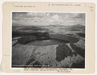
The Jolo Group of Volcanoes, more commonly referred to as the Jolo Group, are an active group of volcanoes in the island of Jolo in Southern Philippines. The Global Volcanism Program lists Jolo as one of the active volcanoes in the Philippines while the Philippine Institute of Volcanology and Seismology (PHIVOLCS) collectively list the group as Bud Dajo, one of the cinder cones on the island.

References

  1. 1 2 "Balut". Global Volcanism Program . Smithsonian Institution.
  2. Presidential Decree No. 1550 (June 11, 1979), An Act Creating the Municipality of Sarangani in the Province of Davao Del Sur, The Lawphil Project, retrieved July 26, 2024
  3. 1 2 Bureau of Insular Affairs (1902). ;"A Pronouncing Gazetteer and geographical Dictionary of the Philippine Islands", p.325. Washington Government Printing Office.
  4. U.S. Army Corps of Engineers (1954). "Caburan (topographic map)". University of Austin Library.
  5. (2010-12-04). "PPA devolves Mabila Port to Sarangani LGU" Archived 2013-11-05 at the Wayback Machine . Philippine Information Agency.
  6. "Balut". Philippine Institute of Volcanology and Seismology. Retrieved on 2013-11-04.
  7. "Parker". Global Volcanism Program . Smithsonian Institution . Retrieved 2011-03-02.