Sarangani, Davao Occidental Last updated November 05, 2025 Municipality in Davao Occidental, Philippines
'Sarangani Island' redirects here. For the other Philippine island near Leyte also sometimes known as Sarangani, see
Limasawa .
Not to be confused with the province of
Sarangani .
Municipality in Davao Region, Philippines
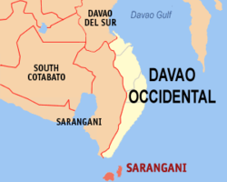
Sarangani , officially the Municipality of Sarangani (Cebuano : Lungsod sa Sarangani Tagalog : Bayan ng Sarangani municipality in the province of Davao Occidental , Philippines . According to the 2020 census, it has a population of 22,515 people, making it the least populated municipality in the province. [ 5]
History On June 11, 1978, the islands of Sarangani and Balut were carved out from the municipality of Jose Abad Santos to form the new municipality of Sarangani, then in Davao del Sur , through Presidential Decree No. 1550 signed by President Ferdinand Marcos . [ 6] On October 28, 2013, the municipality was ceded to Davao Occidental as a result of a plebiscite , in which the majority of voters approved the creation of the new province. [ 7]
Geography Map of the Sarangani islands The municipality consists of two major islands (the eponymous Sarangani Island and Balut Island ) and one minor islet (Olanivan Island), collectively called the Sarangani Islands, located just south of mainland Mindanao island in the Celebes Sea . The municipality shares a maritime border with Sangihe Islands Regency of Indonesia . [ 8]
Climate Sarangani has a tropical rainforest climate (Af) with moderate to heavy rainfall year-round.
Climate data for Sarangani Month Jan Feb Mar Apr May Jun Jul Aug Sep Oct Nov Dec Year Mean daily maximum °C (°F) 31.5 31.8 32.4 32.7 32.0 31.1 30.8 31.1 31.4 31.8 31.9 31.7 31.7 Daily mean °C (°F) 26.4 26.6 27.1 27.5 27.3 26.6 26.3 26.5 26.7 27.0 27.0 26.8 26.8 Mean daily minimum °C (°F) 21.4 21.5 21.8 22.3 22.6 22.2 21.9 22.0 22.1 22.2 22.1 21.9 22.0 Average rainfall mm (inches) 169 137 119 118 165 168 159 115 114 162 166 160 1,752 Source: Climate-Data.org [ 9]
Barangays Sarangani is politically subdivided into 17barangays . Each barangay consists of puroks while some have sitios .
Balut Island
Batuganding Batugan Daguioman Gabon Higug-mang Konel Lipol Mabila (Poblacion ) Tinina Gomtago Tagen Tucal Abila Sarangani Island
Patuco (Sarangani Norte) (includes Olanivan islet ) Laker (Sarangani Sur) Camahual Camalig Pasikao Demographics Due to its proximity to Indonesia, the town also has a significant population of migrants from the Sangihe-Talaud region, including several generations of Indonesian families. As early as 1918, Indonesians extensively planted coconuts in the municipality. Sarangani is also used by Indonesians as a transit point on their way to mainland Mindanao. [ 15]
Economy Poverty incidence of Sarangani
Government Municipal officials 2022-2025:
Mayor: Adelan B. de Arce Vice Mayor: Mariano C. Lagudas Councilors: Arthon M. Gantongan Dionisio D. Wao Jr. Alexis C. Forones Jay William J. Olarte Biyal A. Malong Rodilo P. Dalumpines Steven A. Olarte Jomarie A. Olarte References ↑ Municipality of Sarangani | (DILG) ↑ "2015 Census of Population, Report No. 3 – Population, Land Area, and Population Density" (PDF) . Philippine Statistics Authority . Quezon City, Philippines. August 2016. ISSN 0117-1453 . Archived (PDF) from the original on May 25, 2021. Retrieved July 16, 2021 . ↑ "2024 Census of Population (POPCEN) Population Counts Declared Official by the President" . Philippine Statistics Authority. 17 July 2025. Retrieved 18 July 2025 . ↑ "PSA Releases the 2021 City and Municipal Level Poverty Estimates" . Philippine Statistics Authority. 2 April 2024. Retrieved 28 April 2024 . ↑ "2024 Census of Population (POPCEN) Population Counts Declared Official by the President" . Philippine Statistics Authority. 17 July 2025. Retrieved 18 July 2025 . ↑ Presidential Decree No. 1550 (June 11, 1979), An Act Creating the Municipality of Sarangani in the Province of Davao Del Sur , retrieved July 26, 2024 ↑ Republic Act No. 10360 (January 14, 2013), An Act Creating the Province of Davao Occidental , retrieved July 26, 2024 ↑ "Life along the borders: The Indonesian Sangirs on Balut Island - Asian Center for Journalism" . Asian Center for Journalism . 2014-08-27. Archived from the original on 2024-12-08. Retrieved 2025-05-12 . ↑ "Climate: Sarangani" . Climate-Data.org. Retrieved 28 October 2020 . ↑ "2024 Census of Population (POPCEN) Population Counts Declared Official by the President" . Philippine Statistics Authority. 17 July 2025. Retrieved 18 July 2025 . ↑ Census of Population (2015). "Region XI (Davao Region)" . Total Population by Province, City, Municipality and Barangay . Philippine Statistics Authority . Retrieved 20 June 2016 . ↑ Census of Population and Housing (2010). "Region XI (Davao Region)" (PDF) . Total Population by Province, City, Municipality and Barangay . National Statistics Office . Retrieved 29 June 2016 . ↑ Censuses of Population (1903–2007). "Region XI (Davao Region)" . Table 1. Population Enumerated in Various Censuses by Province/Highly Urbanized City: 1903 to 2007 National Statistics Office . ↑ "Province of" . Municipality Population Data . Local Water Utilities Administration Research Division. Retrieved 17 December 2016 . ↑ Macario D. Tiu (7 September 2006). "The Indonesian Migrants of Davao and Cotabato" . Kyodo Review of Southeast Asia . Retrieved 16 August 2025 . ↑ "Poverty incidence (PI):" . Philippine Statistics Authority. Retrieved December 28, 2020 . ↑ "Estimation of Local Poverty in the Philippines" (PDF) . Philippine Statistics Authority. 29 November 2005. ↑ "2003 City and Municipal Level Poverty Estimates" (PDF) . Philippine Statistics Authority. 23 March 2009. ↑ "City and Municipal Level Poverty Estimates; 2006 and 2009" (PDF) . Philippine Statistics Authority. 3 August 2012. ↑ "2012 Municipal and City Level Poverty Estimates" (PDF) . Philippine Statistics Authority. 31 May 2016. ↑ "Municipal and City Level Small Area Poverty Estimates; 2009, 2012 and 2015" . Philippine Statistics Authority. 10 July 2019. ↑ "PSA Releases the 2018 Municipal and City Level Poverty Estimates" . Philippine Statistics Authority. 15 December 2021. Retrieved 22 January 2022 . ↑ "PSA Releases the 2021 City and Municipal Level Poverty Estimates" . Philippine Statistics Authority. 2 April 2024. Retrieved 28 April 2024 . External links
Places adjacent to Sarangani, Davao Occidental
International National Other
This page is based on this
Wikipedia article Text is available under the
CC BY-SA 4.0 license; additional terms may apply.
Images, videos and audio are available under their respective licenses.