Kingdom of Caboloan Luyag na Caboloan | |||||||||
---|---|---|---|---|---|---|---|---|---|
before 1406–1587 | |||||||||
Capital | Binalatongan | ||||||||
Common languages | Pangasinan language | ||||||||
Religion | Animism | ||||||||
Government | Monarchy | ||||||||
Ari | |||||||||
• 16th century–1587 | Ari Kasikis (disputed) | ||||||||
History | |||||||||
• Established | before 1406 | ||||||||
• Integration into the Spanish East Indies | 1587 | ||||||||
Population | |||||||||
• Census | 3,200 (1591) | ||||||||
| |||||||||
Today part of | Philippines |
History of the Philippines |
---|
![]() |
Timeline |
![]() |
Part of a series on the |
Pre-colonial history of the Philippines |
---|
![]() |
See also: History of the Philippines |
Luyag na Caboloan, known simply as Caboloan, alternatively as Binalatongan, was a sovereign pre-colonial Philippine polity (panarian) situated near the Agno River delta, centered around Binalatongan (modern-day San Carlos). It was reportedly the largest settlement in the entire Pangasinan region. [1] [2] [3]
Caboloan refers to the place where there is an abundance of bolo (Gigantochloa levis), a species of bamboo that abounds at the interior plains of Pangasinan. The term Caboloan has been supplanted by the Spanish Augustinian missionaries from the settlement of Bolinao, who named the entire region from the Lingayen Gulf coastline and the interior as ‘Pangasinan’, which included the region around Binalatongan. [2] : 375–380
It was also known as Luyag na Caboloan, which literally means ‘place known as Caboloan’, [2] : 380 or as ‘luyag ed dapit-ilog’ (a place near the river), while Pangasinan at the coast of Lingayen Gulf were known as ‘luyag ed dapit-baybay’ (place near the coast). [2] : 381
The word Caboloan was first cited in Fr. Mariano Pellicer's book, Arte de la Lengua Pangasinana o Caboloan (1840), which was based on an earlier grammar book in the 1690 by an anonymous author. The term Caboloan remained in use to refer to the interior of Pangasinan until the 19th century. [2] : 381
Caboloan was also alternatively referred to as simply ‘Binalatongan’, which came from the root word balatong (mung beans). [2] : 383
Caboloan's capital, Binalatongan (modern-day San Carlos), located near the Agno River delta, was said to be the largest settlement in the entire region, with over two thousand houses. [1] : 248 Historically, the community of Binalatongan was called Sapan Palapar (wide river), which referred to the Agno River. [2] : 381
According to Baldomero Pulido's doctoral dissertation as well as Restituto Basa, Caboloan was a ‘kingdom’ ruled by a man named Ari Kasikis, while Pangasinan was ruled by Ari Kasilag. This ruler was also mentioned in the census of 1918, 1920 and by the history book ‘History of Lingayen’ (1957) by Santiago S. Velasquez. [2] : 381 According to local legend, the kingdom was said to have spanned Tarlac, Nueva Ecija, Zambales, La Union, Mountain Province and Pangasinan. [4] However, historian Erwin Fernandez (2010) notes that:
“Pangasinan history writers had propagated the names Kasilag and Kasikis as the two kings ruling in the coastal and interior communities contemporaneous with Rajahs Soliman and Lakandula but this contact period account did not cite any of these names. The reason might have been the 1920 source, on which these authors had relied, which mentioned Kasikis – the Census of the Philippine Islands…in the year 1918. Without going to the original sources, historical writers with the exception of historians are liable to writing fiction, not history. This situation similarly applies to the search for the founding date of Pangasinan. Kasikis and Kasilag might be another Urduja or Thalamasin." [3] : 190
After the conquest of Pangasinan by Juan de Salcedo in 1572, the encomienda of Pangasinan was founded as an encomienda. However this did not yet include Caboloan. [5]
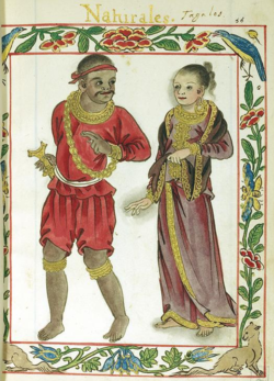
In 1574, the Chinese pirate Limahong landed in Pangasinan to establish his own kingdom. In reaction, the Spaniards landed at San Fabian on 23 March 1575. Afterwards, it was said that the Spaniards climbed at the foot of the Zambales Mountains to observe the kingdom of Ari Kasikis, where they witnessed a highly organized animistic ritual. [4] [5]
In 1587, Binalatongan was founded by Spanish Dominicans as well as Augustinian missionaries such as Fr. Francisco dela Rama who evangelized the natives and established a church known as the Saint Dominic Church. It was reported to be the first town founded by the Dominicans in the Philippines. The mission of Binalatongan was officially accepted as a vicariate of the Dominican Order in its First Provincial Chapter in 1588, with Fr. Bernardo de Santa Catalina, OP, as its first Vicar (equivalent to the office of the parish priest), together with Fr. Juan de Castro, OP, Fr. Marcos de San Antonio, and Bro. Juan Deza, OP as his assistants. [4]
At the start of the foundation, Binalatongan formerly included the towns of Calasiao, Binmaley, Bayambang, Malasiqui, Aguilar, San Carlos City, Urbiztondo, and Basista. [4]
In a letter of Fr. Diego de Rojas to the colonial governor in 29 March 1591, that the people of Caboloan preferred to dwell into the interior rather than settle at the royal encomiendas at the coasts, which were sandy and not suitable for their lifestyle. [2] : 382
In a 1591 report about the various encomiendas of the archipelago, it was reported that Binalatongan had a population of around 3,200 people in total. [3]
In 1611, the province of Pangasinan was made, annexing both the settlements around the Lingayen Gulf excluding Bolinao, as well as the interior settlements, which included Binalatongan, ending its independence as a politically separate territory from Pangasinan. [5]
During the mid Spanish period, Binalatongan was well known as a site of many rebellions within Pangasinan, which included the revolts of Don Andres Malong (1660) and Juan de la Cruz Palaris (1762) during the Seven Years’ War. [4]
On 4 November 1718, in the aftermath of the rebellious period, the capital of Binalatongan would be transferred in what is now known as the poblacion of San Carlos, in which the town would also be renamed the same date. [4]
The people of Caboloan and the people of Pangasinan belonged to a single ethnic group, which is contemporarily referred to simply as ‘Pangasinan’. Similar to other chiefdoms in Pangasinan, the people of Caboloan were also known for their warrior culture. They worshipped Apolaki, the ‘God of War’, who, according to Aduarte, scolded the people for “receiving foreigners with white teeth”, as blackening their teeth was one of their customs. The people of Caboloan also performed tagams (war dances), and were also known as raiders or mangangayaw. [1] : 249
Similar to other cultures in the Philippine Archipelago, they also worshipped anitos and had female shamans. Mourning rites also required human sacrifice and adultery was strictly punished. [1] : 249 [6] : 8
Caboloan was reliant on its bamboo, hence the name of the state. It traded bamboo, beeswax and other forest products with the coastal settlements in exchange for salt and other items coming from the trade with the Ming Chinese. The river Agno was a well-used river for trade, commerce and transport of goods from one place to another. The Agno flows from the interior and into the river delta. [2] : 382 [3]
While disadvantaged with the lack of maritime commerce, Caboloan had an abundance of water supply and arable land, as well as other raw materials. Hence they were referred to as better developed than their coastal counterparts. [2] : 383 They were also known for trading with the Chinese, the Japanese and Indians. It is said that by the time that the Spaniards had arrived, that the people of Caboloan were already wearing gold jewelry and had a well-developed system of agriculture and farming methods. [4]
Lingayen Gulf is a large gulf on northwestern Luzon in the Philippines, stretching 56 km (35 mi). It is framed by the provinces of Pangasinan and La Union and sits between the Zambales Mountains and the Cordillera Central. The Agno River and the Balili River drain into Lingayen Gulf.
The Ilocos Region, designated as Region I, is an administrative region of the Philippines. Located in the northwestern section of Luzon, it is bordered by the Cordillera Administrative Region to the east, the Cagayan Valley to the northeast and southeast, Central Luzon to the south, and the West Philippine Sea to the west.
Anda, officially the Municipality of Anda, is a municipality in the province of Pangasinan, Philippines. According to the 2020 census, it has a population of 41,548 people.
Pangasinan, officially the Province of Pangasinan, is a coastal province in the Philippines located in the Ilocos Region of Luzon. Its capital is Lingayen while San Carlos City is the most populous. Pangasinan is in the western area of Luzon along Lingayen Gulf and the South China Sea. It has a total land area of 5,451.01 square kilometres (2,104.65 sq mi). According to the 2020 census, it has a population of 3,163,190. The official number of registered voters in Pangasinan is 1,651,814. The western portion of the province is part of the homeland of the Sambal people, while the central and eastern portions are the homeland of the Pangasinan people. Due to ethnic migration, the Ilocano people settled in the province.
Aguilar, officially the Municipality of Aguilar, is a municipality in the province of Pangasinan, Philippines. According to the 2020 census, it has a population of 45,100 people.
Bani, officially the Municipality of Bani, is a municipality in the province of Pangasinan, Philippines. According to the 2020 census, it has a population of 52,603 people.
Bautista, officially the Municipality of Bautista, is a municipality in the province of Pangasinan, Philippines. According to the 2020 census, it has a population of 35,398 people.
Binalonan, officially the Municipality of Binalonan, is a municipality in the province of Pangasinan, Philippines. According to the 2020 census, it has a population of 56,382 people.
Burgos, officially the Municipality of Burgos, is a municipality in the province of Pangasinan, Philippines. According to the 2020 census, it has a population of 23,749 people.
Lingayen, officially the Municipality of Lingayen, is a municipality and capital of the province of Pangasinan, Philippines. According to the 2020 census, it has a population of 107,728 people.
Santa Barbara, officially the Municipality of Santa Barbara, is a municipality in the province of Pangasinan, Philippines. According to the 2020 census, it has a population of 92,187 people.
San Carlos, officially the City of San Carlos, is a component city in the province of Pangasinan, Philippines. According to the 2020 census, it has a population of 205,424 people. It is the most populated city in Pangasinan and the entire Ilocos Region.
The Agno River, also known as the Pangasinan River, is a river on the island of Luzon in the Philippines. Traversing the provinces of Benguet, Pangasinan, and Tarlac, it is one of the largest river systems in the country, with a drainage area of 5,952 square kilometres (2,298 sq mi).
Pantaleon Perez, more widely known as Juan de la Cruz, or by his nickname Palaris, was a Pangasinan leader in the province of Pangasinan in the Philippines who led a revolt against the colonial authorities during the 18th century. The uprising is known as the Palaris Revolt.
The Palaris Revolt of 1762–1765 was led by Juan de la Cruz Palaris, also known as "Pantaleón Pérez", of Binalatongan, Pangasinan.
One Pangasinan Alliance or OPAL (DMA) is an economic alliance of six towns and one city of western Pangasinan, representing the 1st District of Pangasinan. It is composed of Alaminos, Agno, Anda, Bani, Bolinao, Burgos, Dasol, Infanta, Mabini & Sual
The Santuario de San Juan Evangelista, also known as the Shrine of St. John the Evangelist or Dagupan Church, is a Roman Catholic church located along Jovellanos Street and Zamora Street, Dagupan, Pangasinan in the Philippines. It belongs to the Archdiocese of Lingayen-Dagupan.
Saint James the Great Parish Church, commonly known as Bolinao Church, is a Spanish colonial Roman Catholic church located at Brgy. Germinal in Bolinao, Pangasinan, Philippines. It is under the jurisdiction of the Diocese of Alaminos. The church was made out of black coral stones. The church underwent series of natural and man-made calamities, such as the 1788 earthquake, 1819 fire incident, and Typhoon Emong in 2009. The said church was the Second largest church in bolinao, the First is the The Jesus Church - Bolinao that was started in March 1, 1969.
Pangasinan was a sovereign coastal pre-colonial Philippine polity (panarian) located at the coasts of Lingayen Gulf. South of Pangasinan was the kingdom of Caboloan, located in the interior of Central Luzon, beside the Agno River basin.
The Minor Basilica of Saint Dominic, formerly known as Saint Dominic Parish Church, is a Roman Catholic minor basilica located in San Carlos, Pangasinan in the Philippines. It is under the jurisdiction of the Archdiocese of Lingayen-Dagupan. The church, made out of bricks or ladrillo, used to be the largest Catholic church in the Philippines during the late 18th century, The church was finished in 1773, under the administration of Father Cristobal Ausina. However, it was destroyed by three earthquakes in 1789, 1796, and 1799.