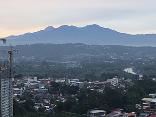
Mount Apo,also known locally as Apo Sandawa,is a large solfataric,dormant stratovolcano on the island of Mindanao,Philippines. With an elevation of 2,954 meters (9,692 ft) above sea level,it is the highest-mountain in the Philippine Archipelago,Mindanao and 24th-highest peak of an island on Earth. Located on the tripartite border of Davao City and Davao del Sur in the Davao Region,and Cotabato in Soccsksargen,Mount Apo is the most-prominent mountain in the Philippines. The peak overlooks from Davao City 45 kilometers (28 mi) to the northeast,Digos 25 kilometers (16 mi) to the southeast,and Kidapawan 20 kilometers (12 mi) to the west. It is a protected area and a Natural Park of the Philippines.

Pinamalayan,officially the Municipality of Pinamalayan,is a 1st class municipality in the province of Oriental Mindoro,Philippines. According to the 2020 census,it has a population of 90,383 people.

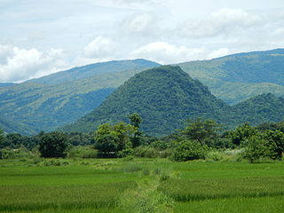
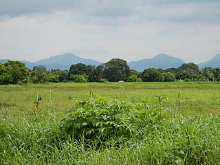
Mount Banahaw is an active complex volcano on Luzon in the Philippines. The three-peaked volcano is located at the boundary of Laguna and Quezon provinces. It is the highest mountain in both provinces and Calabarzon region,dominating the landscape for miles around.

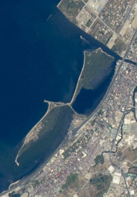
Taal Lake,formerly known as Bombón Lake,is a fresh water caldera lake in the province of Batangas,on the island of Luzon in the Philippines. The lake fills Taal Volcano,a large volcanic caldera formed by very large eruptions between 500,000 and 100,000 years ago.

Sablayan,officially the Municipality of Sablayan,is a 1st class municipality in the province of Occidental Mindoro,Philippines. According to the 2020 census,it has a population of 92,598 people.

Pola,officially the Municipality of Pola,is a 3rd class municipality in the province of Oriental Mindoro,Philippines. According to the 2020 census,it has a population of 35,455 people. It is 74 kilometres (46 mi) from Calapan.

Naujan,officially the Municipality of Naujan,is a 1st class municipality in the province of Oriental Mindoro,Philippines. Its population was 109,587 at the 2020 census.

Roxas,officially the Municipality of Roxas,is a 2nd class municipality in the province of Oriental Mindoro,Philippines. It has a population of 58,849 according to the 2020 census.

San Teodoro,officially the Municipality of San Teodoro,is a 4th class municipality in the province of Oriental Mindoro,Philippines. According to the 2020 census,it has a population of 19,121 people,making it the least populated municipality in the province.

Socorro,officially the Municipality of Socorro,is a 3rd class municipality in the province of Oriental Mindoro,Philippines. According to the 2020 census,it has a population of 41,585 people.

Victoria,officially the Municipality of Victoria,is a 2nd class municipality in the province of Oriental Mindoro,Philippines. According to the 2020 census,it has a population of 52,175 people.

Mount Malindang is a complex volcano located in the province of Misamis Occidental in the southern island of Mindanao,Philippines. It is the highest point in the province. The least studied mountain range was formed through several volcanic activities some of which could be historical,evident by the presence of two calderas,surrounded by high rock walls,cinder cones,dome volcano plugs,two sulfurous hot springs,and a crater lake named Lake Duminagat. The amphitheater structures have extensive distribution of volcanic rocks,carbonized wood that are found in pyroclastic deposits. The mountain range is dissected by several canyons and ravines.
Mahagnao Volcano also known as part of is a dormant stratovolcano located in the Barangay Mahagnao part of the municipality of Burauen province of Leyte,Philippines. It is also bounded by the municipalities of La Paz and MacArthur. The area is mostly composed of wetland forests and also the birth of many rivers and streams flowing on many part of Burauen and on its neighboring towns.
The Bulusan Volcano Natural Park is a 3,673-hectare (9,080-acre) protected area of rainforest surrounding Mount Bulusan in the Philippines. It was first designated as a National Park by Proclamation no. 811 on June 7,1935. Under the National Integrated Protected Areas System (NIPAS) of 1992 managed by the Department of the Environment and Natural Resources,the park was reclassified as a Natural Park by Proc. 421 on November 27,2000. The area features the volcano itself,Bulusan Lake,the two other mountains known as the 'Sharp Peak' and 'Hormahan' and Lake Aguingay. The park is in the south central part of Sorsogon Province,southern Luzon,Bicol Region,Philippines,bounded by five municipalities:Bulusan,Barcelona,Irosin,Juban and Casiguran.

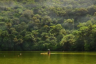
The Mounts Iglit–Baco Natural Park (MIBNP) is a legislated protected area of the Philippines and an ASEAN Heritage Park located in the island of Mindoro in the central Philippines. It was first established in 1970 by virtue of Republic Act No. 6148 as a national park that covered an area of 75,445 hectares surrounding Mount Iglit and Mount Baco in the interior of Mindoro. The park is the home of the largest remaining population of the critically endangered tamaraw. In 2003,the Association of Southeast Asian Nations listed it as one of its four heritage parks in the Philippines. The park has also been nominated to the Tentative List of UNESCO World Heritage Sites in 2006. In 2018,the park was designated as a "Natural Park" under the Republic Act No. 11038 or the Expanded National Integrated Protected Areas Systems (ENIPAS) Act of 2018,which increased the area to 106,656 hectares.
The Las Piñas–Parañaque Critical Habitat and Ecotourism Area (LPPCHEA),also known as the Las Piñas–Parañaque Wetland Park,is a protected area at the coasts of the cities of Las Piñas and Parañaque in Metro Manila,Philippines. The entire wetland is a declared Ramsar site under the Ramsar Convention of UNESCO.
The Manleluag Spring Protected Landscape is a protected area containing natural hot springs in the Ilocos Region of the Philippines. It is one of 34 protected landscapes in the Philippines located in the municipality of Mangatarem,Pangasinan in the west-central area of the island of Luzon.
The Mounts Palay-Palay–Mataas-na-Gulod Protected Landscape is a 3,973.13-hectare (9,817.8-acre) protected area encompassing the Palay-Palay Mountain Range in southwestern Luzon island near Manila in the Philippines. It was established on October 26,1976 as a national park and game refuge and bird sanctuary covering an initial area of 4,000 hectares. In 2007,the national park was designated as a protected landscape area under the National Integrated Protected Areas System through Proclamation No. 1315 signed by President Gloria Arroyo. The park is the last remaining lowland rainforest in the province of Cavite and is well known for Mount Pico de Loro,a popular destination for mountaineers and hikers from Metro Manila.

The Sierra Madre is the longest mountain range in the Philippines. Spanning over 540 kilometers (340 mi),it runs from the province of Cagayan down to the province of Quezon,forming a north–south direction on the eastern portion of Luzon,the largest island of the archipelago. It is bordered by the Pacific Ocean to the east,Cagayan Valley to the northwest,Central Luzon to the midwest,and Calabarzon to the southwest. Some communities east of the mountain range,along the coast,are less developed and so remote that they could only be accessed by taking a plane or a boat.

On the morning of February 28,2023,MT Princess Empress sank off Naujan,Oriental Mindoro,Philippines,causing an oil spill in the waters of the provinces of Antique,Batangas,Oriental Mindoro,and Palawan. En route from Bataan to Iloilo,the oil tanker was carrying 900,000 liters of industrial fuel oil before it sank.


