
Laguna, officially the Province of Laguna, is a province in the Philippines located in the Calabarzon region in Luzon. Its capital is Santa Cruz while its largest city is the City of Calamba and the province is situated southeast of Metro Manila, south of the province of Rizal, west of Quezon, north of Batangas and east of Cavite. Laguna hugs the southern shores of Laguna de Bay, the largest lake in the country. As of the 2020 census, the total population of Laguna is 3,382,193. Among all 82 provinces in the Philippines, Laguna accounted for the largest share (5%) of the national Gross Domestic Product (GDP) with a total of Php 990.69 billion in 2022.

Calabarzon, sometimes referred to as Southern Tagalog and designated as Region IV‑A, is an administrative region in the Philippines. The region comprises five provinces: Batangas, Cavite, Laguna, Quezon, and Rizal; and one highly urbanized city, Lucena. It is the most populous region in the Philippines, according to the Philippine Statistics Authority (PSA), having over 16.1 million inhabitants in 2020, and is also the country's second most densely populated after the National Capital Region. It is situated southeast of Metro Manila, and is bordered by Manila Bay and South China Sea to the west, Lamon Bay and the Bicol Region to the east, Tayabas Bay and the Sibuyan Sea to the south, and Central Luzon to the north. It is home to places like Mount Makiling near Los Baños, Laguna, and Taal Volcano in Batangas. Calamba is the regional center while Antipolo is the most populous city in the region.

Cavinti, officially the Municipality of Cavinti, is a 3rd class municipality in the province of Laguna, Philippines. According to the 2020 census, it has a population of 23,980 people.

Kalayaan, officially the Municipality of Kalayaan, is a 3rd class municipality in the province of Laguna, Philippines. According to the 2020 census, it has a population of 24,755 people.

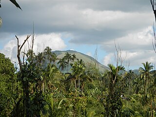
Mount Banahaw is an active complex volcano on Luzon in the Philippines. The three-peaked volcano is located at the boundary of Laguna and Quezon provinces. It is the highest mountain in both provinces and Calabarzon region, dominating the landscape for miles around.

Tanay, officially the Municipality of Tanay, is a 1st class municipality in the province of Rizal, Philippines. According to the 2020 census, it has a population of 139,420 people.

Sariaya, officially the Municipality of Sariaya, is a 1st class municipality in the province of Quezon, Philippines. According to the 2020 census, it has a population of 161,868 people making it the second most populous in Quezon Province after the capital city of Lucena.
Dolores, officially the Municipality of Dolores, is a 4th class municipality in the province of Quezon, Philippines. According to the 2020 census, it has a population of 32,514 people.

Naujan Lake is a freshwater lake in the Philippines located in the northeastern corner of the province of Oriental Mindoro on Mindoro Island. The lake is the fifth largest in the country and the main geographical feature of the Naujan Lake National Park. The entire area is a Ramsar Wetland Site since 1999.

Mount Makiling is an inactive stratovolcano located in the provinces of Laguna and Batangas on the island of Luzon in the Philippines. The mountain rises to an elevation of 1,090 meters (3,580 ft) above mean sea level and is the highest feature of the Laguna Volcanic Field. The volcano has no recorded historic eruption but volcanism is still evident through geothermal features like mud spring and hot springs. South of the mountain is the Makiling–Banahaw Geothermal Plant. The Philippine Institute of Volcanology and Seismology (PHIVOLCS) classifies the volcano as "Inactive".
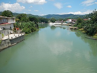
The Bumbungan River is a river in the province of Laguna in the Philippines. It is commonly referred to as the Pagsanjan River because of the popularity of the municipality of Pagsanjan and Pagsanjan Falls, one of the province's tourist destinations. The municipality of Pagsanjan was named so because it is where the Balanac River, originating from Mount Banahaw, joins the Bumbungan. Its old name, Pinagsangahan, which literally means branching, was changed to Pagsanjan during the Spanish Colonial Era.
Rafflesia philippensis is a parasitic plant species of the Rafflesiaceae family that was named by Francisco Manuel Blanco in his Flora de Filipinas in 1845. The species is known only from a mountain located between the provinces of Laguna and Quezon, Luzon where it was first discovered. Its plant host is Tetrastigma pisicarpum. This species went unnoticed since its first description by Blanco but was rediscovered in 2003 by members of the Tanggol Kalikasan, a local environment conservation group in Quezon province who first saw and photographed the open flower of this species. It was brought to the attention of Manuel S. Enverga University (MSEUF), who formed a team composed of students and faculty to document the newly discovered Rafflesia species.

Quezon, officially the Province of Quezon, is a province in the Philippines located in the Calabarzon region on Luzon. Kalilayan was the first known name of the province upon its creation in 1591. Around the middle of the 18th century, it was renamed Tayabas. In 1946, in recognition of the second president of the Philippines, Manuel L. Quezon, the name of Tayabas Province was changed to Quezon. Lucena, the provincial capital, the seat of the provincial government, and the most populous city of the province, is governed independently from the province as a highly urbanized city. To distinguish the province from Quezon City, it is sometimes called Quezon Province, a variation of the province's official name.
The Seven Lakes of San Pablo are seven volcanic crater lakes scattered around the City of San Pablo, in the province of Laguna, Philippines.

The Laguna Volcanic Field, also known as the San Pablo Volcanic Field, is an active volcanic field in the Philippines, located between Laguna de Bay, Mount Banahaw volcano complex and Mount Malepunyo range. It is part of the larger Southwestern Luzon Volcanic Field (SWLVF). From Manila, it is about 50 kilometres (31 mi) southeast to Mount Makiling, its most prominent volcanic feature.

Villa Escudero Plantations and Resort is an 800 hectares of working coconut plantation and hacienda in Tiaong, Quezon, 10 kilometres (6.2 mi) south of the city of San Pablo, Laguna on the border with Quezon. Since 1981, the plantation has opened its doors as a resort offering village tours, a museum tour, food and accommodations. It has developed a worldwide reputation as a focal point to experience Philippine culture and history in a beautiful rural setting.

Mount Sungay, also known as Mount Gonzales, is a mountain in the province of Cavite in the Philippines. Located in eastern Tagaytay, the inactive stratovolcano is the highest point in the province of Cavite, at 709 metres. The slopes of the mountain are the source of the San Cristobal River that flows from the mountain to Silang, Cavite down to its mouth at Laguna de Bay in Calamba, Laguna.

The Quezon Protected Landscape is a protected area in the Republic of the Philippines, spanning the municipalities of Pagbilao, Padre Burgos and Atimonan in Quezon province. The park is situated north of the narrowest section of Luzon in Quezon province, located about 164 km (102 mi) southeast of Metro Manila.

Mounts Banahaw–San Cristobal Protected Landscape is a protected landscape park in the Calabarzon region of the Philippines, 120 kilometres (75 mi) south of Manila. It is the second largest protected area in Calabarzon, after the Upper Marikina River Basin Protected Landscape, with an area of 10,900.59 hectares. The park is located at the border of Laguna and Quezon provinces and includes the features it is named after: Mount Banahaw and, 7 kilometres (4.3 mi) to its west, Mount San Cristobal.

