
Costa Rica is located on the Central American Isthmus, surrounding the point 10° north of the equator and 84° west of the prime meridian. It has 212 km of Caribbean Sea coastline and 1,016 on the North Pacific Ocean.
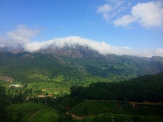
The Western Ghats or the Sahyadri Mountain range is a mountain range that covers an area of 160,000 km2 (62,000 sq mi) in a stretch of 1,600 km (990 mi) parallel to the western coast of the Indian peninsula, traversing the states of Maharashtra, Goa, Karnataka, Gujarat, Kerala, and Tamil Nadu. It is a UNESCO World Heritage Site and is one of the eight biodiversity hotspots in the world. It is sometimes called the Great Escarpment of India. It contains a very large proportion of the country's flora and fauna, many of which are endemic to these region. According to UNESCO, the Western Ghats are older than the Himalayas. They influence Indian monsoon weather patterns by intercepting the rain-laden monsoon winds that sweep in from the south-west during late summer. The range runs north to south along the western edge of the Deccan Plateau and separates the plateau from a narrow coastal plain called Konkan along the Arabian Sea. A total of 39 areas in the Western Ghats, including national parks, wildlife sanctuaries and reserve forests, were designated as world heritage sites in 2012 – twenty in Kerala, ten in Karnataka, six in Tamil Nadu and four in Maharashtra.

The Madagascar subhumid forests are a tropical moist broadleaf forest ecoregion that covers most of the Central Highlands of the island of Madagascar. They are included in the WWF's Global 200 list of outstanding ecoregions. Most of the original habitats have been lost due to human pressure.
The Tropical Rainforest Heritage of Sumatra site was inscribed as a UNESCO World Heritage site in 2004. It comprises three Indonesian national parks on the island of Sumatra: Gunung Leuser National Park, Kerinci Seblat National Park and the Bukit Barisan Selatan National Park. The site is listed under Criteria vii - outstanding scenic beauty; ix- an outstanding example representing significant on-going ecological and biological processes; and x- contains the most important and significant natural habitats for in-situ conservation. The Tropical Rainforest Heritage of Sumatra has been placed on the Danger List since 2011 to help overcome threats posed by poaching, illegal logging, agricultural encroachment, and plans to build roads through the site.

The Sri Lanka montane rain forests is an ecoregion found above 1,000 m in the central highlands of Sri Lanka. Owing to their rich biodiversity, this region is considered to be a super-hotspot within endemic hotspots of global importance. These forests are cooler than lowland forests and therefore they have ideal conditions for growth of cloud forests. These forests classifications tropical sub montane forest, tropical sub-montane and tropical upper montane. Half of Sri Lanka's endemic flowering plants and 51 percent of the endemic vertebrates are restricted to these forests. More than 34 percent of Sri Lanka's endemic trees, shrubs, and herbs can only be found in this ecoregion. Twisted, stunted trees are a common sight in these forests, together with many varieties of orchids, mosses and ferns. The trees of montane rain forests grow to a height 10–15 meters, shorter than the lowland rain forest trees. These high altitude forests are the catchment area for most of Sri Lanka's major rivers.

The wildlife of Ivory Coast consists of the flora and fauna of this nation in West Africa. The country has a long Atlantic coastline on the Gulf of Guinea and a range of habitat types. Once covered in tropical rainforest, much of this habitat has been cleared, the remaining terrain being gallery forests and savanna with scattered groups of trees, resulting in a decrease in biodiversity. As of 2016, 252 species of mammal had been recorded in Ivory Coast, 666 species of bird, 153 species of reptile, 80 species of amphibian, 671 species of fish and 3660 species of vascular plant.

The New Guinea Highlands, also known as the Central Range or Central Cordillera, is a long chain of mountain ranges on the island of New Guinea, including the island's tallest peak, Puncak Jaya 16,024 ft (4,884 m), the highest mountain in Oceania. The range is home to many intermountain river valleys, many of which support thriving agricultural communities. The highlands run generally east-west the length of the island, which is divided politically between Indonesia in the west and Papua New Guinea in the east.
The Mount Cameroon and Bioko montane forests is a tropical moist broadleaf forest ecoregion in central Africa. It occupies the upper slopes of coastal Mount Cameroon in Cameroon, and the mountains of nearby Bioko island in Equatorial Guinea.
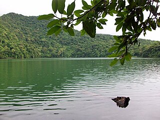
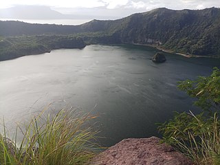
Lake Bulusan is a lake on Luzon Island in the Philippines. It lies at the heart of Bulusan Volcano National Park which covers a land area of 3,672 hectares. It has an elevation of 360 metres (1,180 ft) and is located on the southeast flank of Mount Bulusan, an active volcano.
The Comoros forests is a terrestrial ecoregion which covers the Comoro Islands, which lie in the Mozambique Channel between Madagascar and East Africa. These include four main islands: Grande Comore, Anjouan and Mohéli, of the Union of the Comoros, and Mayotte, a department and region of France.
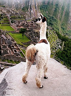
Peru has some of the greatest biodiversity in the world. It belongs to the select group of mega diverse countries because of the presence of the Andes, Amazon rainforest, and the Pacific Ocean. It has the fourth-most tropical forests of any country and the ninth-most forest area.
The Bulusan Volcano Natural Park is a 3,673-hectare (9,080-acre) protected area of rainforest surrounding Mount Bulusan in the Philippines. It was first designated as a National Park by Proclamation no. 811 on June 7, 1935. Under the National Integrated Protected Areas System (NIPAS) of 1992 managed by the Department of the Environment and Natural Resources, the park was reclassified as a Natural Park by Proc. 421 on November 27, 2000. The area features the volcano itself, Bulusan Lake, the two other mountains known as the 'Sharp Peak' and 'Hormahan' and Lake Aguingay. The park is in the south central part of Sorsogon Province, southern Luzon, Bicol Region, Philippines, bounded by five municipalities: Bulusan, Barcelona, Irosin, Juban and Casiguran.
Ecotourism in the United States is commonly practiced in protected areas such as national parks and nature reserves. The principles and behaviors of ecotourism are slowly becoming more widespread in the United States; for example, hotels in some regions strive to be more sustainable.

The Angolan Scarp savanna and woodlands is an ecoregion located on the coast of Angola, an area with a variety of habitats and rich in wildlife including many endemic birds and animals.

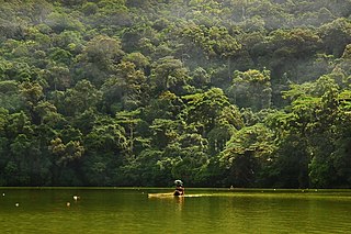
Tortuguero National Park is a national park in the Limón Province of Costa Rica. It is situated within the Tortuguero Conservation Area of the northeastern part of the country. Despite its remote location, reachable only by airplane or boat, it is the third-most visited park in Costa Rica. The park has a large variety of biological diversity due to the existence within the reserve of eleven different habitats, including rainforest, mangrove forests, swamps, beaches, and lagoons. Located in a tropical climate, it is very humid, and receives up to 250 inches (6,400 mm) of rain a year.

The East African montane forests is a montane tropical moist forest ecoregion of eastern Africa. The ecoregion comprises several separate areas above 2000 meters in the mountains of South Sudan, Uganda, Kenya, and Tanzania.
Aguingay or Agingay is a legendary lady mistress of the warrior of Bulusan in the town's most popular folklore. She is the main character of the epic: Si Bulusan nan Si Aguingay believed to have existed hundred of years before Spaniards set foot in the islands of the Philippines.
The Luzon rain forests is a tropical moist broadleaf forest ecoregion on the island of Luzon. Luzon is the largest island in the Philippines, and the Luzon rain forests is the most extensive rainforest ecoregion of the country. The ecoregion includes the lowlands of Luzon and neighboring islands below 1000 meters elevation. Very little of the original rainforest remains, and the status of this area is critical/endangered.

The Magdalena Valley dry forests (NT0221) is an ecoregion in Colombia along the upper Magdalena River, a large river that runs from south to north between the two main cordilleras of the Andes. There are many endemic species, but much of the original habitat has been destroyed by agriculture and over-grazing, mainly by goats. The habitat is not protected by any national park, and is at risk of complete destruction.

The Luzon montane rain forests is a tropical moist broadleaf forest ecoregion on the island of Luzon in the Philippines. The ecoregion is located on several volcanic and non-volcanic mountains of the island. Luzon is the largest and northernmost major island of the Philippines, located in the western Pacific Ocean.


