The Philippines is an archipelago that comprises 7,641 islands with a total land area of 300,000 square kilometers (115,831 sq mi). It is the world's 5th largest island country. The eleven largest islands contain 95% of the total land area. The largest of these islands is Luzon at about 105,000 square kilometers (40,541 sq mi). The next largest island is Mindanao at about 95,000 square kilometers (36,680 sq mi). The archipelago is around 800 kilometers (500 mi) from the Asian mainland and is located between Taiwan and Borneo.

The San Juan Mountains are a high and rugged mountain range in the Rocky Mountains in southwestern Colorado and northwestern New Mexico. The area is highly mineralized and figured in the gold and silver mining industry of early Colorado. Major towns, all old mining camps, include Creede, Lake City, Silverton, Ouray, and Telluride. Large scale mining has ended in the region, although independent prospectors still work claims throughout the range. The last large scale mines were the Sunnyside Mine near Silverton, which operated until late in the 20th century and the Idarado Mine on Red Mountain Pass that closed down in the 1970s. Famous old San Juan mines include the Camp Bird and Smuggler Union mines, both located between Telluride and Ouray.

McArthur–Burney Falls Memorial State Park is the second oldest state park in the California State Parks system, located approximately 6 miles (9.7 km) north of Burney, California. The park offers camping, fishing, watersports, hiking and horseback riding facilities. The park is mainly known for the waterfall, Burney Falls, at the entrance of the park. Wildlife in the park includes bass, trout, Steller's jay, squirrels, woodpeckers, deer, and on rare occasion, black bear.

The Tallulah River is a 47.7-mile-long (76.8 km) river in Georgia and North Carolina. It begins in Clay County, North Carolina, near Standing Indian Mountain in the Southern Nantahala Wilderness and flows south into Georgia, crossing the state line into Towns County. The river then travels through Rabun County and ends in Habersham County. It cuts through the Tallulah Dome rock formation to form the Tallulah Gorge and its several waterfalls. The Tallulah River intersects with the Chattooga River to form the Tugaloo River at Lake Tugalo in Habersham County, which then joins South Carolina's Seneca River at Lake Hartwell to create the Savannah River which flows southeastward into the Atlantic Ocean.

The Santa Ana River is the largest river entirely within Southern California in the United States. It rises in the San Bernardino Mountains and flows for most of its length through San Bernardino and Riverside Counties, before cutting through the northern Santa Ana Mountains via Santa Ana Canyon and flowing southwest through urban Orange County to drain into the Pacific Ocean. The Santa Ana River is 96 miles (154 km) long, and its drainage basin is 2,650 square miles (6,900 km2) in size.

The Tehachapi Mountains are a mountain range in the Transverse Ranges system of California in the Western United States. The range extends for approximately 40 miles (64 km) in southern Kern County and northwestern Los Angeles County.

The Santa Ana Mountains are a short peninsular mountain range along the coast of Southern California in the United States. They extend for approximately 61 miles (98 km) southeast of the Los Angeles Basin largely along the border between Orange and Riverside counties.

The San Bernardino Mountains are a high and rugged mountain range in Southern California in the United States. Situated north and northeast of San Bernardino and spanning two California counties, the range tops out at 11,503 feet (3,506 m) at San Gorgonio Mountain – the tallest peak in all of Southern California. The San Bernardinos form a significant region of wilderness and are popular for hiking and skiing.

Siaton, officially the Municipality of Siaton, is a 1st class municipality and the southernmost settlement in the province of Negros Oriental, Philippines. According to the 2015 census, it has a population of 77,696 people.

Quake Lake is a lake in southwestern Montana in the United States. It was created after an earthquake struck on August 17, 1959, killing 28 people. Quake Lake is 190 feet (58 m) deep and 6 miles (9.7 km) long. US 287 follows the lake and offers glimpses of the effects of the earthquake and landslide, and a visitor center is just off the road. The lake is mostly within Gallatin National Forest.
The Bartang is a river of Central Asia, tributary to the Panj and consequently to the Amu Darya. In its upper reaches, it is known as the Murghab and Aksu; it flows through the Wakhan in Afghanistan, then through the Rushon District of the Gorno-Badakhshan autonomous region, Tajikistan. The river is 528 kilometres (328 mi) long and has a basin area of 24,700 square kilometres (9,500 sq mi).

The Mount Meager massif is a group of volcanic peaks in the Pacific Ranges of the Coast Mountains in southwestern British Columbia, Canada. Part of the Cascade Volcanic Arc of western North America, it is located 150 km (93 mi) north of Vancouver at the northern end of the Pemberton Valley and reaches a maximum elevation of 2,680 m (8,790 ft). The massif is capped by several eroded volcanic edifices, including lava domes, volcanic plugs and overlapping piles of lava flows; these form at least six major summits including Mount Meager which is the second highest of the massif.

The 1959 Hebgen Lake earthquake occurred on August 17 at 11:37 pm (MST) in southwestern Montana, United States. The earthquake measured 7.2 on the Moment magnitude scale, caused a huge landslide, resulted in over 28 fatalities and left US$11 million in damage. The slide blocked the flow of the Madison River, resulting in the creation of Quake Lake. Significant effects of the earthquake were also felt in nearby Idaho and Wyoming, and lesser effects as far away as Puerto Rico and Hawaii.
Santiago Creek is a major watercourse in Orange County in the U.S. state of California. About 34 miles (55 km) long, it drains most of the northern Santa Ana Mountains and is a tributary to the Santa Ana River. It is one of the longest watercourses entirely within the county. The creek shares its name with Santiago Peak, at 5,687 ft (1,733 m) the highest point in Orange County, on whose slopes its headwaters rise.

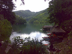
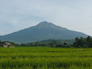
Mount Talinis, also known as the Cuernos de Negros, is a complex volcano in the Philippine province of Negros Oriental. At about 1,903 metres (6,243 ft) above sea level, it is the second highest mountain on Negros Island after Mount Kanlaon. The volcano is located 9 km (5.6 mi) southwest of the municipality of Valencia; and 20 km (12 mi) from Dumaguete City, the capital of the province.

Wells Gray Provincial Park is a large wilderness park located in east-central British Columbia, Canada. The park protects most of the southern, and highest, regions of the Cariboo Mountains and covers 5,250 square kilometres. It is British Columbia's fourth largest park, after Tatshenshini, Spatsizi and Tweedsmuir.
Mizoram is a land of rolling hills, valleys, rivers and lakes in Northeast India. As many as 21 major hills ranges or peaks of different heights run through the length and breadth of the state, with plains scattered here and there. The average height of the hills to the west of the state are about 1,000 metres. These gradually rise up to 1,300 metres to the east. Some areas, however, have higher ranges which go up to a height of over 2,000 metres.
Negros is the fourth largest island in the Philippines, with a total land area of 13,309 km2 (5,139 sq mi). Negros is one of the many islands that comprise the Visayas, in the central part of the country. The predominant inhabitants of the island region are mainly called Negrenses. As of 2015, the total population of Negros is 4,414,131.

The La Mesa Watershed Reservation is a protected area that preserves the only major watershed in Metro Manila, Philippines. Also known as the Novaliches Watershed, it contains the last remaining rainforest of its size in Metro Manila surrounding the La Mesa Dam and Reservoir, the primary source of potable drinking water for 12 million residents in the Manila metropolitan area. The area is under the joint administration, supervision and control of the Department of Environment and Natural Resources and the Metropolitan Waterworks and Sewerage System. It was established in 2007 through Proclamation No. 1336 issued by President Gloria Arroyo.

The Matilija Wilderness is a 29,207-acre (11,820 ha) wilderness area in Ventura and Santa Barbara Counties, Southern California. It is managed by the U.S. Forest Service, being situated within the Ojai Ranger District of the Los Padres National Forest. It is located adjacent to the Dick Smith Wilderness to the northwest and the Sespe Wilderness to the northeast, although it is much smaller than either one. The Matilija Wilderness was established in 1992 in part to protect California condor habitat.