
Mindanao is the second-largest island in the Philippines, after Luzon, and seventh-most populous island in the world. Located in the southern region of the archipelago, the island is part of an island group of the same name that also includes its adjacent islands, notably the Sulu Archipelago. According to the 2020 census, Mindanao had a population of 26,252,442, while the entire island group had an estimated population of 27,021,036.

Mayon, also known as Mount Mayon and Mayon Volcano, is an active stratovolcano in the province of Albay in Bicol, Philippines. A popular tourist spot, it is renowned for its "perfect cone" because of its symmetric conical shape, and is regarded as sacred in Philippine mythology.

Mount Apo is the highest mountain peak in the Philippines, with an elevation of 2,954 meters (9,692 ft) above sea level. A large solfataric, dormant stratovolcano, it is part of the Apo-Talomo Mountain Range of Mindanao island. Apo is situated on the tripartite border of Davao City, Davao del Sur, and Cotabato; its peak is visible from Davao City 45 kilometers (28 mi) to the northeast, Digos 25 kilometers (16 mi) to the southeast, and Kidapawan 20 kilometers (12 mi) to the west. Apo is a protected area and is the centerpiece of Mount Apo Natural Park.

Bukidnon, officially the Province of Bukidnon, is a landlocked province in the Philippines located in the Northern Mindanao region. Its capital is the city of Malaybalay while Valencia is the largest city. The province borders, clockwise from the north, Misamis Oriental, Agusan del Sur, Davao del Norte, Cotabato, Lanao del Sur, and Lanao del Norte. According to the 2020 census, the province is inhabited by 1,541,308 residents. The province is composed of 2 component cities and 20 municipalities. It is the third largest province in the country in terms of total area of jurisdiction behind Palawan and Isabela respectively.

Lantapan, officially the Municipality of Lantapan, is a 1st class municipality in the province of Bukidnon, Philippines. According to the 2020 census, it has a population of 65,974 people.

Taal Volcano is a large caldera filled by Taal Lake in the Philippines. Located in the province of Batangas about 50 kilometers (31 mi) south of Manila, the volcano is the second most active volcano in the country with 38 recorded historical eruptions, all of which were concentrated on Volcano Island, near the middle of Taal Lake. The caldera was formed by prehistoric eruptions between 140,000 and 5,380 BP.

Valencia, officially the City of Valencia, is a 1st class component city in the province of Bukidnon, Philippines. According to the 2020 census, it has a population of 216,546 people. The city is applying for a Highly Urbanized City (HUC).
Maramag, officially the Municipality of Maramag, is a 1st class municipality in the province of Bukidnon, Philippines. According to the 2020 census, it has a population of 108,293 people.

The Lumad are a group of Austronesian indigenous peoples in the southern Philippines. It is a Cebuano term meaning "native" or "indigenous". The term is short for Katawhang Lumad, the autonym officially adopted by the delegates of the Lumad Mindanao Peoples Federation (LMPF) founding assembly on 26 June 1986 at the Guadalupe Formation Center, Balindog, Kidapawan, Cotabato. Usage of the term was accepted in Philippine jurisprudence when President Corazon Aquino signed into law Republic Act 6734, where the word was used in Art. XIII sec. 8(2) to distinguish Lumad ethnic communities from the islands of Mindanao.

Mount Bulusan, also known as Bulusan Volcano, is a stratovolcano on the island of Luzon in the Philippines. Located in the province of Sorsogon in the Bicol Region, it is 70 kilometres (43 mi) southeast of Mayon Volcano and approximately 390 kilometres (240 mi) southeast of Manila. Bulusan is one of the active volcanoes in the Philippines.
Kanlaon, also known as Mount Kanlaon and Kanlaon Volcano, is an active andesitic stratovolcano and the highest mountain on the island of Negros in the Philippines, as well as the highest peak in the Visayas, with an elevation of 2,465 m (8,087 ft) above sea level. Mount Kanlaon ranks as the 42nd-highest peak of an island in the world.

Mount Hibok-Hibok is a stratovolcano on Camiguin Island in the Philippines. One of the active volcanoes in the country, it is part of the Pacific ring of fire.

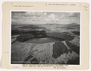
Musuan Peak or Mount Musuan, also known as Mount Calayo is an active volcano in Maramag, Bukidnon, on the island of Mindanao in the Philippines. It is 4.5 kilometres (2.8 mi) south of the city of Valencia, province of Bukidnon, and 81 kilometres (50 mi) southeast of Cagayan de Oro.
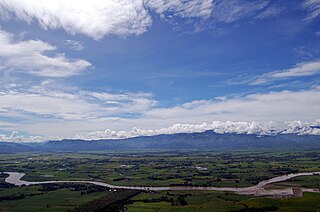
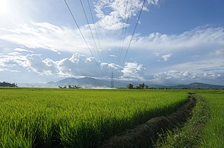
The Pulangi River ;, also spelled Pulangui, is one of the major tributaries of the Rio Grande de Mindanao, an extensive river system in Mindanao, Philippines. With a length of 320 kilometres (199 mi), it is the longest river in Bukidnon and the 5th longest river in the Philippines. It traverses through majority of the cities and municipalities of Bukidnon from its source in Barangay Kalabugao, Impasugong, Bukidnon.

Mount Dulang-dulang, dubbed by Filipino mountaineers as "D2" and also known as Mount Katanglad, is the highest elevation peak in the Kitanglad Mountain Range, located in the north central portion of the province of Bukidnon in the island of Mindanao. It is the second highest mountain of the Philippines at 2,941 metres (9,649 ft) above sea level, second only to Mount Apo of Davao at 2,956 m (9,698 ft) and slightly higher than Mount Pulag of Luzon, the third highest at 2,928 m (9,606 ft).

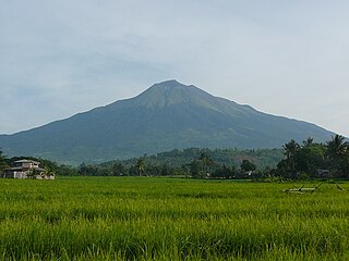
Mount Talinis is a complex volcano in the Philippine province of Negros Oriental. At about 1,903 metres (6,243 ft) above sea level, it is the second highest mountain on Negros Island after Mount Kanlaon, and the tallest peak in the mountain range known as the Cuernos de Negros. The volcano is located 9 km (5.6 mi) southwest of the municipality of Valencia; and 20 km (12 mi) from Dumaguete, the capital of the province.

Mount Malindang is a complex volcano located in the province of Misamis Occidental in the southern island of Mindanao, Philippines. It is the highest point in the province. The least studied mountain range was formed through several volcanic activities some of which could be historical, evident by the presence of two calderas, surrounded by high rock walls, cinder cones, dome volcano plugs, two sulfurous hot springs, and a crater lake named Lake Duminagat. The amphitheater structures have extensive distribution of volcanic rocks, carbonized wood that are found in pyroclastic deposits. The mountain range is dissected by several canyons and ravines.

Mount Kalatungan, also known as Keretungan by the indigenous Manobo people, is a volcanic mountain located in the province of Bukidnon in the southern Philippines. It is a stratovolcano with no known historical eruptions and classified by the Philippine Institute of Volcanology and Seismology (PHIVOLCS) as a potentially active volcano. It is the fifth highest mountain in the Philippines and is an indigenous and community conserved area (ICCA).
The Jolo Group of Volcanoes, more commonly referred to as the Jolo Group, are an active group of volcanoes on the island of Jolo in Southern Philippines. The Global Volcanism Program lists Jolo as one of the active volcanoes in the Philippines while the Philippine Institute of Volcanology and Seismology (PHIVOLCS) collectively lists the group as Bud Dajo, one of the cinder cones on the island.


