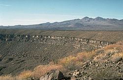
Maars range in size from 20 to 3,000m (66 to 9,800ft) across and from 5 to 200m (20 to 700ft) deep.[2][3] Most maars fill with water to form natural lakes. Most maars have low rims composed of a mixture of loose fragments of volcanic rocks and rocks torn from the walls of the diatreme.[3]
Etymology
The name maar comes from a Moselle Franconian dialect word used for the circular lakes of the Daun area of Germany. The word evolved from its first use in German in the modern geological sense in 1819 and is now used in English and in the geological sciences as the term for the explosion crater, even if water from rainfall might always have drained from the crater after the formation event. This extension in meaning was due to recognising that the lake may no longer exist. Since maar lakes are formed after initially ground or subsurface water interacts with a magma intrusion to create an explosion crater, the name came to be used for the crater type as well.[Note 1] The present definition of the term[1] relates to both its common and scientific discourse use in language over two centuries. Depending upon context there may be other descriptors available to use in the geological sciences such as the term tuff ring or maar-diatreme volcanoes.[4] These last are volcanoes produced by explosive eruptions that cut deeply into the country rock with the maar being "the crater cut into the ground and surrounded by an ejecta ring".[4] A 2011 geological clarification of a maar is "Maar volcanoes are distinguished from other small volcanoes in having craters with their floor lying below the pre-eruptive surface".[4]
Maar lakes and dry maars
Maar lakes, also referred to simply as maars, occur when groundwater or precipitation fills the funnel-shaped and usually round hollow of the maar depression formed by volcanic explosions. Examples of these types of maar are the three maars at Daun in the Eifel mountains of Germany.
A dry maar results when a maar lake dries out, becomes aggraded or silted up. An example of the latter is the Eckfelder Maar. Near Steffeln is the Eichholzmaar (also called the Gussweiher) which has dried out during the last century and is being renaturalised into a maar. In some cases the underlying rock is so porous that maar lakes are unable to form. After winters of heavy snow and rainfall many dry maars fill partially and temporarily with water; others contain small bogs or often artificial ponds that, however, only occupy part of the hollow.[citation needed]
Distribution
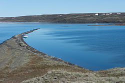
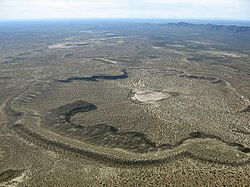
The largest known maars are found at Espenberg on the Seward Peninsula in northwest Alaska. These maars range in size from 4 to 8km (2.5 to 5.0mi) in diameter and a depth up to 300m (980ft). These eruptions occurred in a period of about 100,000 years, with the youngest (the Devil Mountain Maar) occurring about 17,500 years ago. Their large size is due to the explosive reaction that occurs when magma comes into contact with permafrost. Hydromagmatic eruptions are increasingly explosive when the ratio of water to magma is low. Since permafrost melts slowly, it provides a steady source of water to the eruption while keeping the water to magma ratio low. This produces the prolonged, explosive eruptions that created these large maars. Examples of the Seward Peninsula maars include North Killeak Maar, South Killeak Maar, Devil Mountain Maar and Whitefish Maar.[5]
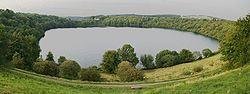
The three maars at Daun (from front to rear): the Gemündener, Weinfelder and Schalkenmehrener MaarWeinfelder MaarSchalkenmehrener Maar
In the Volcanic Eifel there are about 75 maars. Both lake-filled and dry maars are typical, though the latter are more common. The last eruptions took place at least 11,000 years ago, and many maars are older, as evidenced by their heavy erosion and less obvious shapes and volcanic features.[8]
In Germany there are also several maars outside of the Eifel. A well-known example is the Messel pit, a former maar lake near Messel in the county of Darmstadt-Dieburg and which is known for its well preserved fossils. In addition in the Swabian Jura and the Albvorland (the Swabian Volcano) there are maar-forming volcanoes. Because the over 350 eruption points were only active in the Upper Miocene 17 to 11million years ago, all the maars, apart from the dry maar, Randecker Maar and the Molach, are only detectable geologically. In the Ore Mountains near Hammerunterwiesenthal, the Hammerunterwiesenthal Maar formed about 30million years ago during the Oligocene; the maar measures 2 kilometres from east to west and 1.4 kilometres from north to south.
In Central Mexico, the Tarascan volcanic field contains several maars in the states of Michoacán and Guanajuato. The Río Cuarto and Hule maars are in Costa Rica. In Nicaragua is the maar of Laguna de Xiloa, part of the Apoyeque volcano. From South America, there are known maars in Chile (e.g. Cerro Overo and Cerro Tujle in northern Chile). Jayu Khota is a maar in Bolivia.
According to German Wikipedia's "Maar" article, in 1544 in his book Cosmographia, Sebastian Münster (1488–1552) first applied the word "maar" (as Marh) to the Ulmener Maar and the Laacher See.[unreliable source] See: Sebastian Münster, Cosmographia (Basel, Switzerland: Heinrich Petri, 1544), p. 341. From p. 341: "Item zwen namhafftiger seen seind in der Eyfel / einer bey de schloß Ulmen / und ein ander bey dem Closter züm Laich / die seind sere tieff / habe kein ynflüß aber vil außflüß / die nennet man Marh unnd seind fischreich." (Also two noteworthy lakes are in the Eifel, one by the Ulmen castle, and another by the monastery at Laich; they are very deep; [they] have no streams flowing in but many flowing out; one calls them "maars" and [they] are rich in fish.)
In 1819, Johann Steininger (1794–1874), a secondary-school teacher from Trier, coined the term "maar" in its modern sense. See: Steininger, J., Geognostische Studien am Mittelrhein [Geological studies on the middle Rhein] (Mainz, (Germany): Kupferberg, 1819).
In 1825, George Julius Poulett Scrope (1797–1876) introduced the term "maar" into English. See: Scrope, G.P., Considerations on Volcanoes (London, England: Philipps, 1825), p. 166.
Horst Noll, a geologist at the University of Köln (Cologne), Germany, said that the local term maar might even have derived from the Latin word mare (i.e. sea) and been introduced into local language during the Roman occupation of the West Eifel. See: Noll, H. (1967) "Maare und Maar-ähnliche Explosionskrater in Island. Ein Vergleich mit dem Maar-Vulkanismus der Eifel" (Maars and maar-like explosion craters in Iceland. A comparison with the maar-volcanism of the Eifel.), Special publication of the Geological Institute of the University of Köln, p. 1.
Wilhelm Meyer, Geologie der Eifel [Geology of the Eifel] (Stuttgart, Germany: Schweizerbart'sche Verlagsbuchhandlung, 1986), p. 311.
↑Wilhelm Meyer. "Die Geologie". Heimatjahrbuch 2006 (in German). Kreis Ahrweiler. Archived from the original on 2016-05-25. Retrieved 2016-01-21. zu Ungeklärte Herkunft des Rodder Maars
↑Neumann, F.; Schölzel, C.; Litt, T.; Hense, A.; Stein, M. (2007). "Holocene vegetation and climate history of the northern Golan heights (Near East)". Vegetation History and Archaeobotany. 16 (4): 329–346. Bibcode:2007VegHA..16..329N. doi:10.1007/s00334-006-0046-x. S2CID129220670.
Formation of volcanoes - maar, animation on YouTube, Czech Geological Survey, 2019, duration 1 min 56 sec. English subtitles available. Retrieved 2025-02-04.
This page is based on this Wikipedia article Text is available under the CC BY-SA 4.0 license; additional terms may apply. Images, videos and audio are available under their respective licenses.