
The Eifel is a low mountain range in western Germany, eastern Belgium and northern Luxembourg. It occupies parts of southwestern North Rhine-Westphalia, northwestern Rhineland-Palatinate and the southern area of the German-speaking Community of Belgium.
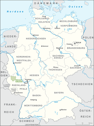
Vulkaneifel is a district (Kreis) in the northwest of the state Rhineland-Palatinate, Germany. It is the least densely populated district in the state and the fourth most sparsely populated district in Germany. The administrative centre of the district is in Daun. Neighboring districts are Euskirchen, Ahrweiler, Mayen-Koblenz, Cochem-Zell, Bernkastel-Wittlich, and Bitburg-Prüm.

A maar is a broad, low-relief volcanic crater caused by a phreatomagmatic eruption. A maar characteristically fills with water to form a relatively shallow crater lake, which may also be called a maar.

Daun is a town in the Vulkaneifel district in Rhineland-Palatinate, Germany. It is the district seat and also the seat of the Verbandsgemeinde of Daun.

Boos is a municipality in the county of Mayen-Koblenz in Rhineland-Palatinate, western Germany.
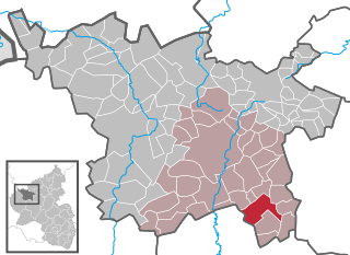
Gillenfeld is an Ortsgemeinde – a municipality belonging to a Verbandsgemeinde, a kind of collective municipality – in the Vulkaneifel district in Rhineland-Palatinate, Germany. It belongs to the Verbandsgemeinde of Daun, whose seat is in the like-named town.

The Volcanic Eifel or Vulkan Eifel, also known as the East Eifel Volcanic Field (EEVF), is a region in the Eifel Mountains in Germany that is defined to a large extent by its volcanic geological history. Characteristic of this volcanic field are its typical explosion crater lakes or maars, and numerous other signs of volcanic activity such as volcanic tuffs, lava streams and volcanic craters like the Laacher See. The Volcanic Eifel is still volcanically active today. One sign of this activity is the escaping gases in the Laacher See.

The Hohe Acht is the highest mountain in the Eifel mountains of Germany. It is located on the boundary between the districts of Ahrweiler and Mayen-Koblenz in Rhineland-Palatinate.
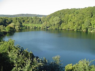
The Weinfelder Maar, also called the Totenmaar, is a maar around two kilometres southeast of the town of Daun in the Eifel Mountains, in the German state of Rhineland-Palatinate.

The Volcano Park in Mayen-Koblenz is a geopark in the rural district of Mayen-Koblenz in the eastern Vulkan Eifel, Germany. It was founded in 1996 and wraps around the Laacher See. Together with the Volcano Park, Brohltal/Laacher See and the Vulkan Eifel Nature and Geo-Park, it forms part of the national Eifel Volcano Land Geo-Park. The three parks are connected by the 280-kilometre-long German Volcano Route.

The Ernstberg southeast of Hinterweiler is, at 698.8 m, the highest of the west Eifel volcanoes and, after the Hohe Acht, the second highest mountain in the Eifel overall. Its summit consists of pyroclastic rocks (Schweißschlacken) that form a volcanic crater that is open towards the east. This is where the basalt masses flowed out, forming a semicircle on the eastern slope of the mountain. It lies within the Waldeifel region.
The Ulmener Maar is a maar in the Eifel mountains of Germany in the immediate vicinity of the town of Ulmen in the state of Rhineland-Palatinate. The lake is up to 37 metres deep and is surrounded by an embankment of tuff with an average height of 20 metres, which was formed from the erupted material of the former volcano. By the southern edge of the embankment are the ruins of a knight's castle, Ulmen Castle dating to the 11th century.
The Volcanic Eifel Nature Park lies in the counties of Bernkastel-Wittlich, Cochem-Zell and Vulkaneifel in the German state of Rhineland-Palatinate. The nature park, which is in the Eifel mountains, and which is also a geopark, was inaugurated on 31 May 2010 and has an area of 1,068.24 km2.> Its sponsor is the Natur- und Geopark Vulkaneifel GmbH.

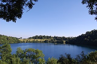
The Pulvermaar is a water-filled maar that lies southeast of Daun in the German state of Rhineland-Palatinate. Together with the Holzmaar it is one of the Gillenfeld maars.

The Dreiser Weiher near Dreis-Brück in the vicinity of Daun in the German state of Rhineland-Palatinate is a tub-shaped maar in the Eifel mountains. It is up to 1,360 metres long and 1,160 metres wide. It is the second largest maar in the Eifel.

The Hochsimmer is a volcanic cone, 587.9 m above sea level (NHN), in the Eifel Mountains in Germany. It rises near Ettringen in the Rhineland-Palatine county of Mayen-Koblenz. At the summit is an observation tower, the Hochsimmer Tower.

The Hochstein is a volcanic cone, 563 m above sea level (NHN), in the Eifel near Obermendig in the German state of Rhineland-Palatinate and county of Mayen-Koblenz.

The Mosbrucher Weiher, also called the Mosbrucher Maar, is a silted up maar east of the municipal boundary of the village of Mosbruch in the county Vulkaneifel in Germany. It is located immediately at the foot of the 675-metre-high Hochkelberg, a former volcano. The floor of the maar is in the shape of an elongated oval and is about 700×500 metres in size, its upper boundary has a diameter of about 1,300 × 1,050 metres. This makes the Mosbrucher Maar the third largest of the maars in the western Eifel region. The Üßbach stream flows past and close to the Mosbrucher Weiher.

The Rockeskyller Kopf near Rockeskyll in the county of Vulkaneifel in the German state of Rhineland-Palatinate is a hill, 554.6 m above sea level (NHN), in the Eifel mountains. It is an extinct volcano complex from the Quaternary period, around 360,000 years old and is designated as a natural monument (ND-7233-420).
The Ettringer Bellerberg, also called the Ettringer Bellberg, is a hill, 427.5 m above sea level (NHN), forming the western flank of the Bellerberg Volcano, a volcano system that was active about 200,000 years ago.
