Volcanic Eifel

Last updated
The Laacher See, the largest volcanic crater lake in Central Europe near Andernach. Laacher See - Luftaufnahme.jpg
The Laacher See, the largest volcanic crater lake in Central Europe near Andernach.
The Weinfelder Maar or Totenmaar, one of three maars near Daun. Dauner Maar.jpg
The Weinfelder Maar or Totenmaar, one of three maars near Daun.
Tephra layers in a quarry near Weibern in the Brohl Valley. WeibernV.JPG
Tephra layers in a quarry near Weibern in the Brohl Valley.
Mofettas on the southeastern shore of the Laacher See. Laacher See, Mofetten.jpg
Mofettas on the southeastern shore of the Laacher See.

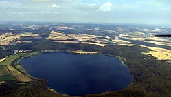
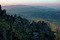
The Volcanic Eifel or Vulkan Eifel (German : Vulkaneifel), also known as the East Eifel Volcanic Field (EEVF), [1] is a region in the Eifel Mountains in Germany that is defined to a large extent by its volcanic geological history. Characteristic of this volcanic field are its typical explosion crater lakes or maars, and numerous other signs of volcanic activity such as volcanic tuffs, lava streams and volcanic craters like the Laacher See. The Volcanic Eifel is still volcanically active today. One sign of this activity is the escaping gases in the Laacher See.

Contents

Geographical location

The Wingertsbergwand gives an idea of the amount of volcanic ash ejected during the eruption of the Laacher See volcano. Wingertsbergwand Laacher See 2010.jpg
The Wingertsbergwand gives an idea of the amount of volcanic ash ejected during the eruption of the Laacher See volcano.

The Volcanic Eifel stretches from the Rhine to the Wittlich Depression. It is bordered in the south and southwest by the South Eifel, in the west by Luxembourg and Belgian Ardennes and in the north by the North Eifel including the Hohes Venn. To the east the Rhine forms its geographical boundary, with no volcanicity immediately beyond it.

The Volcanic Eifel is divided into three natural regions:

The centre of the Volcanic Eifel is the region around Daun and Manderscheid and the areas within the Mayen-Koblenz district.

The landscape of the Volcanic Eifel is dominated by recent volcanism. Volcanic craters, thick pumice and basalt layers and maars create a diverse landscape that clearly witnesses to very recent events in geological terms.

The entire Volcanic Eifel covers an area of about 2,000 km2 (770 sq mi) and as of 2007 has a population of about 200,000.

Volcanoes

The following volcanoes belong to the Eifel, sorted by height in metres (m) above sea level (Normalhöhennull, NHN) [2] :

Laacher See

Of particular note is the volcanic caldera known as Laacher See, the site of an eruption around 12,900 years ago that had an estimated VEI of 6.

Geopark and museums

Geology

The tephras deposited by past eruptions of the Volcanic Eifel are lithological deposits that are radiometrically dateable via argon-argon dating of K-feldspar grains. These have in turn been utilised to ascertain the ages of climatic changes such as transitions from glacial to interglacial states during the Pleistocene. [1]

Future activity

There is thought that future eruptions may occur in the Eifel, as: [3] [4]

In 2020, Professor Kreemer noted that Eifel was the only region within an area of Europe studied where ground motion happened at significantly higher levels than expected. [5] It is possible that such movements originate from a rising magma plume. [5] This activity does not imply an immediate eruptive danger, but might suggest an increase in volcanic and seismic activity in the region. [5]

Related Research Articles

<span class="mw-page-title-main">Eifel</span> Low mountain range in Germany

The Eifel is a low mountain range in western Germany, eastern Belgium and northern Luxembourg. It occupies parts of southwestern North Rhine-Westphalia, northwestern Rhineland-Palatinate and the southern area of the German-speaking Community of Belgium.

Vulkaneifel is a district (Kreis) in the northwest of the state Rhineland-Palatinate, Germany. It is the least densely populated district in the state and the fourth most sparsely populated district in Germany. The administrative centre of the district is in Daun. Neighboring districts are Euskirchen, Ahrweiler, Mayen-Koblenz, Cochem-Zell, Bernkastel-Wittlich, and Bitburg-Prüm.

Mayen-Koblenz is a district (Kreis) in the north of Rhineland-Palatinate, Germany. Neighboring districts are Ahrweiler, Neuwied, Westerwaldkreis, district-free Koblenz, Rhein-Lahn, Rhein-Hunsrück, Cochem-Zell, and Vulkaneifel.

<span class="mw-page-title-main">Maar</span> Low-relief volcanic crater

A maar is a broad, low-relief volcanic crater caused by a phreatomagmatic eruption. A maar characteristically fills with water to form a relatively shallow crater lake, which may also be called a maar.

<span class="mw-page-title-main">Daun, Germany</span> Town in Rhineland-Palatinate, Germany

Daun is a town in the Vulkaneifel district in Rhineland-Palatinate, Germany. It is the district seat and also the seat of the Verbandsgemeinde of Daun.

<span class="mw-page-title-main">Laacher See</span> Volcanic caldera lake in Ahrweiler, Rhineland-Palatinate

Laacher See, also known as Lake Laach or Laach Lake, is a volcanic caldera lake with a diameter of 2 km (1.2 mi) in Rhineland-Palatinate, Germany, about 24 km (15 mi) northwest of Koblenz, 37 km (23 mi) south of Bonn, and 8 km (5.0 mi) west of Andernach. It is in the Eifel mountain range, and is part of the East Eifel volcanic field within the larger Volcanic Eifel. The lake was formed by a Plinian eruption approximately 13,000 years BP with a Volcanic Explosivity Index (VEI) of 6, on the same scale as the Pinatubo eruption of 1991. The volcanic discharge observable as mofettas on the southeastern shore of the lake are signs of dormant volcanism.

<span class="mw-page-title-main">Dockweiler</span> Municipality in Rhineland-Palatinate, Germany

Dockweiler is an Ortsgemeinde – a municipality belonging to a Verbandsgemeinde, a kind of collective municipality – in the Vulkaneifel district in Rhineland-Palatinate, Germany. It belongs to the Verbandsgemeinde of Daun, whose seat is in the like-named town.

<span class="mw-page-title-main">Gillenfeld</span> Municipality in Rhineland-Palatinate, Germany

Gillenfeld is an Ortsgemeinde – a municipality belonging to a Verbandsgemeinde, a kind of collective municipality – in the Vulkaneifel district in Rhineland-Palatinate, Germany. It belongs to the Verbandsgemeinde of Daun, whose seat is in the like-named town.

<span class="mw-page-title-main">Nohn</span> Municipality in Rhineland-Palatinate, Germany

Nohn is an Ortsgemeinde – a municipality belonging to a Verbandsgemeinde, a kind of collective municipality – in the Vulkaneifel district in Rhineland-Palatinate, Germany. It belongs to the Verbandsgemeinde of Gerolstein, whose seat is in the like-named town.

<span class="mw-page-title-main">Steffeln</span> Municipality in Rhineland-Palatinate, Germany

Steffeln is an Ortsgemeinde – a municipality belonging to a Verbandsgemeinde, a kind of collective municipality – in the Vulkaneifel district in Rhineland-Palatinate, Germany. It belongs to the Verbandsgemeinde of Gerolstein, whose seat is in the municipality of Gerolstein.

<span class="mw-page-title-main">Strohn</span> Municipality in Rhineland-Palatinate, Germany

Strohn is an Ortsgemeinde – a municipality belonging to a Verbandsgemeinde, a kind of collective municipality – in the Vulkaneifel district in Rhineland-Palatinate, Germany. It belongs to the Verbandsgemeinde of Daun, whose seat is in the like-named town.

<span class="mw-page-title-main">Hohe Acht</span>

The Hohe Acht is the highest mountain in the Eifel mountains of Germany. It is located on the boundary between the districts of Ahrweiler and Mayen-Koblenz in Rhineland-Palatinate.

<span class="mw-page-title-main">Volcano Park, Mayen-Koblenz</span>

The Volcano Park in Mayen-Koblenz is a geopark in the rural district of Mayen-Koblenz in the eastern Vulkan Eifel, Germany. It was founded in 1996 and wraps around the Laacher See. Together with the Volcano Park, Brohltal/Laacher See and the Vulkan Eifel Nature and Geo-Park, it forms part of the national Eifel Volcano Land Geo-Park. The three parks are connected by the 280-kilometre-long German Volcano Route.

<span class="mw-page-title-main">Booser Doppelmaar</span> Geological formation in western Germany

The Booser Doppelmaar comprises two maars that have silted up and, today, form shallow depressions in the countryside. They lie on the territory of the village of Boos, a few hundred metres west of the village itself. The two maars were formed 10,150 to 14,160 years ago and belong to the Quaternary volcano field of the Volcanic Eifel. From a natural region perspective it lies in the south of the Hohe Acht Upland, ca. 7.8 km south of the summit of the Hohe Acht.

<span class="mw-page-title-main">Volcano Museum, Daun</span> Volcano museum in Rhineland-Palatinate, Germany

The Volcano Museum in the old district administrative office (Landratsamt) in Daun, Germany, was set up as an extension of the existing 'geopaths' at Hillesheim, Manderscheid and Gerolstein and is part of the Volcanic Eifel Nature and Geopark.

<span class="mw-page-title-main">German Volcano Route</span> Tourist route from the River Rhine to the mountains of the High Eifel

The German Volcano Route or, less commonly, German Volcano Road is a 280-kilometre-long tourist route from the River Rhine to the mountains of the High Eifel. It links 39 sites within the Geopark Vulkanland Eifel in the Volcanic Eifel (Vulkaneifel), at which geological, cultural-historical and industrial-historical nature and cultural monuments on the subject of volcanicity in the Eifel are located.

<span class="mw-page-title-main">Hochsimmer</span>

The Hochsimmer is a volcanic cone, 587.9 m above sea level (NHN), in the Eifel Mountains in Germany. It rises near Ettringen in the Rhineland-Palatine county of Mayen-Koblenz. At the summit is an observation tower, the Hochsimmer Tower.

<span class="mw-page-title-main">Hochstein (Eifel)</span>

The Hochstein is a volcanic cone, 563 m above sea level (NHN), in the Eifel near Obermendig in the German state of Rhineland-Palatinate and county of Mayen-Koblenz.

<span class="mw-page-title-main">Rockeskyller Kopf</span> Mountain in Germany

The Rockeskyller Kopf near Rockeskyll in the county of Vulkaneifel in the German state of Rhineland-Palatinate is a hill, 554.6 m above sea level (NHN), in the Eifel mountains. It is an extinct volcano complex from the Quaternary period, around 360,000 years old and is designated as a natural monument (ND-7233-420).

References

  1. 1 2 van den Bogaard, P.; Hall, C. M.; Schmincke, H.-U.; York, D. (30 November 1989). "Precise single-grain 40Ar/39 Ar dating of a cold to warm climate transition in Central Europe". Nature . 342 (6249): 523–525. doi:10.1038/342523a0. ISSN   1476-4687 . Retrieved 19 December 2023.
  2. GeoViewer of the Federal Office of Geoscience and Resources (Bundesanstalt für Geowissenschaften und Rohstoffe)
  3. Is there still volcanic activity in the Eifel?
  4. Germany: a danger of volcanic eruptions?
  5. 1 2 3 Kettley, Sebastian (11 June 2020). "Volcano warning: 'Something is brewing under Europe' Geologists make incredible discovery". Express. Retrieved 5 May 2021.

Further reading

50°17′N7°00′E / 50.283°N 7.000°E / 50.283; 7.000