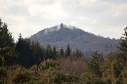
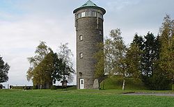
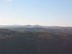
Elevation Height Eifel region(s) District / Province Remarks Image Hohe Acht 746.9 High Eifel Ahrweiler , Mayen-Koblenz Highest elevation in thevolcano ; Kaiser Wilhelm Tower Ernstberg 698.8 Vulkan Eifel Vulkaneifel Highest of the west Eifel volcanos; volcano unnamed peak? Schwarzer Mann ) 699.1 Vulkan Eifel Vulkaneifel Highest of the west Eifel volcanos; volcano Schwarzer Mann 697.8 Schnee Eifel , Schneifel Eifelkreis Bitburg-Prüm Highest point of the Schneifel ridge Signal de Botrange 694.24 Hohes Venn Liège (B ) Highest mountain in Belgium and the Hohes Venn Weißer Stein 693 North Eifel , Zitter Forest Euskirchen Highest mountain of the Zitter Forest and in North Rhine-Westphalia west of the Rhine; second highest mountain in Belgium; site of observation tower on the (German) eastern slopes of the mountain Scharteberg 691.4 Vulkan Eifel Vulkaneifel Second highest elevation in the Vulkan Eifel, SWR ’s Eifel Transmitter Burgberg ("castle mountain")Nürburg 676.5 High Eifel Ahrweiler Second highest elevation in the High Eifel; volcano ; Nordschleife of the old Nürburgring ; site of Nürburg castle Hochkelberg 674.9 High Eifel Vulkaneifel Third highest elevation in the High Eifel; stratovolcano ; Prümscheid 674.7 Vulkan Eifel Vulkaneifel Highest point of the ridge in the Salm Forest near Gerolstein Schöneberg 670.2 North Eifel Ahrweiler Raßberg 664.9 High Eifel Mayen-Koblenz Seimersberg 662.9 Schnee-Eifel Eifelkreis Bitburg-Prüm Bärbelkreuz 662.8 Zitterwald Euskirchen Nearby: Eifel-Bärbelkreuz Transmission Tower Pannensterzkopf (Bovel) 662 Hohes Venn Liège (B ) Hühnerhöhe 659.9 North Eifel , Zitter Forest Euskirchen Steling 658.3 Hohes Venn Aachen (D ), Liège (B ) Highest mountain in the district of Aachen Steinberg 657.8 Schneifel Vulkaneifel Foltenhöhe 656 North Eifel Landkreis Euskirchen Huppertsberg 655.5 North Eifel Landkreis Euskirchen Döhmberg 653.2 Volcanic Eifel Vulkaneifel Gieschberg 652.0 North Eifel Euskirchen Site of the village of Giescheid on the summit Nerother Kopf 651.7 Volcanic Eifel Vulkaneifel Type: cinder cone ; Freudenkoppe Prümer Kopf 645.6 Schnee Eifel Eifelkreis Bitburg-Prüm Bockshahn 643.7 High Eifel Ahrweiler Rote Heck 639.9 High Eifel Vulkaneifel Kamberg 637.8 North Eifel , Zitterwald Euskirchen Eselsberg 637 Vulkan Eifel Vulkaneifel Hahnheister 636.3 High Fens Aachen (GE ), Liège (B ) Auf dem Gericht 632.8 West Eifel Vulkaneifel Apert 631.3 South Eifel Eifelkreis Bitburg-Prüm Hohe Warte 628.2 North Eifel Ahrweiler Aremberg 623.8 Ahr Hills Ahrweiler Highest elevation of the Ahr Hills; Burg Aremberg Dietzenley 617.6 Volcanic Eifel Vulkaneifel Highest mountain of the Pelmer Forest, site of wooden observation post Auf der Kopp 615.5 South Eifel Eifelkreis Bitburg-Prüm Höchstberg 616 Vulkan Eifel Vulkaneifel Auf der Wurst 615.0 North Eifel Ahrweiler Dreiser Höhe 610.8 High Eifel Vulkaneifel Hohe Mark 609 High Fens Liège (B ) Huscheid 607.9 West Eifel Eifelkreis Bitburg-Prüm Steffelnkopf 607 Schnee Eifel Vulkaneifel Hardtkopf 601.5 South Eifel Eifelkreis Bitburg-Prüm Highest hill on the edge of the Prümer Kalkmulde Achelter 595.7 Schnee Eifel Vulkaneifel / Eifelkreis Bitburg-Prüm Heidenköpfe see:Heidenkopf I :Heidenkopf II :Heidenkopf III : D 595,00 [ 2] 591,00 0 ,00 Ripsdorf Forest , North Eifel Euskirchen / Vulkaneifel Rödelkaul 592.3 Volcanic Eifel Vulkaneifel Arensberg 561.3 Vulkan Eifel Vulkaneifel Daxelberg 588.7 Vulkan Eifel Vulkaneifel Alter Voß 589.9 Volcanic Eifel Vulkaneifel Bradscheid 588.2 Volcanic Eifel Vulkaneifel Hochsimmer 587.9 High Eifel Mayen-Koblenz Site of the Hochsimmer Tower , an observation tower Michelsberg 586.1 Ahr Hills Euskirchen Highest elevation in Bad Münstereifel ; unnamed summit Langschoß 583.67 Hohes Venn , Hürtgen Forest Aachen , Düren Site of the old NATO direction-finding station, an observation tower and a telecommunication tower; Perlerkopf 579.1 North Eifel Ahrweiler Gänsehals 575.3 High Eifel Mayen-Koblenz Denskopf 577.0 High Eifel Mayen-Koblenz Lichtenborner Höhe 570.6 South Eifel Eifelkreis Bitburg-Prüm Kalvarienberg 569 Schneifel Eifelkreis Bitburg-Prüm Prüm explosion , 1949 Engelner Kopf 569 North Eifel Ahrweiler Dackscheidberg 568 South Eifel Eifelkreis Bitburg-Prüm Losenseifen 568 South Eifel Eifelkreis Bitburg-Prüm Eigart 565 North Eifel Euskirchen Eifel National Park Hochstein 562.5 High Eifel Mayen-Koblenz Site of Genoveva Cave Auf dem Thron 562 North Eifel Ahrweiler Mäuseberg 561 Vulkan Eifel Vulkaneifel Site of Dronke Tower Kneiff 560 ??? Eifel Diekirch District , Luxembourg Highest point in Luxembourg Buurgplaatz 559 ??? Eifel Diekirch District , Luxembourg Second highest point in Luxembourg; often erroneously thought to be the highest Steineberger Ley 558 Vulkan Eifel Vulkaneifel Site of Vulcano Infoplattform (observation tower) Junkerberg 557 Ahr Hills Ahrweiler Rockeskyller Kopf 555 Vulkan Eifel Vulkaneifel Type: volcano Winterberg 555 Vulkan Eifel Vulkaneifel Daxberg 549 South Eifel Vulkaneifel Hoher List 549 Vulkan Eifel Vulkaneifel Site of Hoher List Observatory Alter Burgberg 548 High Eifel Ahrweiler , Vulkaneifel Auf Holbert 543 South Eifel Eifelkreis Bitburg-Prüm Ahrberg 540 High Eifel Vulkaneifel Hahn 539 Schnee-Eifel Vulkaneifel Hirzberg 538 Ripsdorfer Wald Euskirchen Knippberg 537 Ahr Hills Euskirchen Muxerather Höhe 535 South Eifel Eifelkreis Bitburg-Prüm Hühnerberg 533.5 Ahr Hills Euskirchen Hohe Kuppe 531 South Eifel Eifelkreis Bitburg-Prüm Steinerberg 531 North Eifel Ahrweiler Kuppe near Wolfgarten 527.8 Rur Eifel , Kermeter Euskirchen Highest elevation in the Kermeter ; Eifel National Park ; Fire Tower Scheidkopf 527 Osteifel Mayen-Koblenz Hellberg 525.8 Rur Eifel , Kermeter Euskirchen Eifel National Park Wildbretshügel 525.3 Rur Eifel , Kermeter Euskirchen Eifel National Park Goldberg 523 South Eifel Vulkaneifel Kalvarienberg 523 North Eifel Euskirchen Kirchberg 520 North Eifel Euskirchen Lenzerath 519.3 Schnee-Eifel Vulkaneifel Mosenberg 519 Vulkan Eifel Bernkastel-Wittlich Site of Windsborn summit cross and observation post Verbrannter Berg 515.5 Rur Eifel , Kermeter Euskirchen Eifel National Park Kopnück 514 Ahr Hills Euskirchen Wendelsberg 513 Vulkan Eifel Vulkaneifel site of Daun Deer Park Geerberg 510 Vulkan Eifel Cochem-Zell , Mayen-Koblenz Vulkan Kalem 509,4 South Eifel Vulkaneifel Häuschen 507 North Eifel Ahrweiler Ruins of an observation tower Hahnenkopf 505 South Eifel Eifelkreis Bitburg-Prüm Winterberg 503.4 Rur Eifel , Kermeter Site of Kermeterstollen below the western flanks of the hill Hochthürmen 499.8 North Eifel Ahrweiler , Euskirchen Site of Roman circular fort Pflugberg 498 North Eifel Euskirchen Teufelsley 496 North Eifel Ahrweiler Hardtberg 495 South Eifel Eifelkreis Bitburg-Prüm Honigberg 495 Rur Eifel , Kermeter Düren Eifel National Park ; viewing point for the Rur Reservoir Adert 488 North Eifel Ahrweiler Popular viewing point Hasenberg 471 North Eifel Ahrweiler Römerberg 470 Vulkan Eifel Vulkaneifel Krufter Ofen 463 Vulkan Eifel Mayen-Koblenz Weidenauer Berg 453.3 Rur Eifel , Kermeter Düren Eifel National Park Laacher Kopf 442 Vulkan Eifel Ahrweiler Nearby: Maria Laach Abbey and Laacher See Kellerberg 448 Meulenwald Bernkastel-Wittlich Highest elevation of the Meulenwald; Stockert 435 Münstereifel Forest Euskirchen Site of Astropeiler Stockert radio-telescope Herkelstein 434.5 North Eifel Euskirchen Veitskopf 428 Vulkan Eifel Ahrweiler Type: volcano ; Laacher See ; site of Observation tower Lydia Tower Ettringer Bellerberg 427.5 High Eifel Mayen-Koblenz Site of crater landscape Hummerich 425 Vulkan Eifel Mayen-Koblenz Type: volcano ; Laacher See Monzeler Hüttenkopf 421 Moselle Hills Bernkastel-Wittlich Mehringer Berg 418 Moselle Hills Trier-Saarburg Falkenlay 414 Pre-Eifel Cochem-Zell Observation post below the summit Hansenberg 401 Moselle Hills Bernkastel-Wittlich Zoonenberg 401 Meulenwald Trier-Saarburg Burgberg 400.5 Rur Eifel , North Eifel Düren Site of former Berenstein imperial castle and Krawutschke observation tower Thelenberg 400 Vulkan Eifel Mayen-Koblenz / Ahrweiler Arenberg 399 Pre-Eifel Cochem-Zell Sollig 398 Pre-Eifel Cochem-Zell Hühnerberg 398 Ahr Hills Ahrweiler Nearby: Effelsberg Radio Telescope Sonnenberg 393,3 Rur Eifel , North Eifel Düren Eickelslay 390 Moselle Eifel Blumkirst 389 Pre-Eifel Cochem-Zell Hornberg 388 North Eifel Ahrweiler Calmont 378 Pre-Eifel Cochem-Zell Has the steepest individual vineyard in Europe Hochkopf 376 North Eifel Rhein-Sieg-Kreis Thomasberg 378 Moselle Hills Bernkastel-Wittlich Steckenberg 366 North Eifel Ahrweiler Site of observation tower Rothenberg 365 Moselle Hills Bernkastel-Wittlich Mayener Bellerberg („Mayener Bellberg“) 363 High Eifel Mayen-Koblenz Krausberg 360 North Eifel Ahrweiler Site of Krausberg Tower and Krausberghütte Römerberg 359 Meulenwald Trier-Saarburg Bausenberg 340 North Eifel Ahrweiler Type: volcano Neuenahrer Berg 339 North Eifel Ahrweiler Site of ruined castle of Neuenahr and Langer Köbes observation tower Tomberg 316 North Eifel Rhein-Sieg-Kreis Type: volcano ; Tomburg castle Hochburg 306 South Eifel Trier-Saarburg Old Celtic refuge castle: Hochburg Elterlay 294 South Eifel Trier-Saarburg Genoveva Cave Beuelskopf 291.9 North Eifel Rhein-Sieg-Kreis Remains of the Hans-Wischeler Tower Scheidskopf 280 North Eifel Ahrweiler Site of partly accessible quarry and Roman ringwork Landskrone 272 North Eifel Ahrweiler Site of Landskron Castle