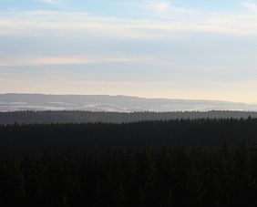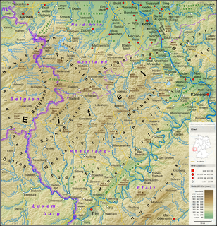
The Eifel is a low mountain range in western Germany and eastern Belgium. It occupies parts of southwestern North Rhine-Westphalia, northwestern Rhineland-Palatinate and the southern area of the German-speaking Community of Belgium.

The Schneifel is a range of low mountains, up to 699.1 m above sea level (NHN), in the western part of the Eifel in Germany, near the Belgian border. It runs from Brandscheid near Prüm in a northeasterly direction to Ormont. The name Schneifel has nothing to do with the German words Schnee (snow) and Eifel. It is derived from the former dialect of this region and means something like Schneise ("swathe"). This swathe ran over the mountains. The term was "Germanised" during the Prussian era and the term Schnee-Eifel was born, albeit referring to a larger area.

The West Eifel refers to that part of the Eifel mountains in Germany that is centred on the town of Prüm and reaches as far as the border with Belgium and Luxembourg. It is not geographically precisely defined however, overlapping by about 60% with the Schnee Eifel), whilst geologically its northern half is part of the Vulkaneifel and its southern half part of the South Eifel.

The Erbeskopf is a mountain in the Hunsrück range in central Germany. At a height of 816 metres (2,677 ft), it is the highest point in the state of Rhineland-Palatinate, as well as the highest point of German territory on the western bank of the Rhine. It lies within the Saar-Hunsrück Nature Park.
The Schnee Eifel is a heavily wooded landscape in Germany's Central Uplands, up to 699.1 m above sea level (NHN), that forms part of the western Eifel in the area of the German-Belgian border. The name may have been derived in the 19th century from the Schneifel chain of hills which had nothing to do with snow (Schnee), but with the name for a forest swathe (Schneise).

At 746.9 m above sea level (NHN), the Hohe Acht is the highest mountain in the Eifel mountains of Germany. It is located on the boundary between the districts of Ahrweiler and Mayen-Koblenz in Rhineland-Palatinate.

The Ahr Hills are a range of low mountains and hills up to 623.8 m above sea level (NHN) and 25 kilometres (16 mi) long in the Eifel region of Germany, which lie roughly southwest of Bonn on the border between the German states of North Rhine-Westphalia and Rhineland-Palatinate.

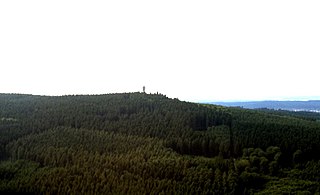
The Aremberg is, at 623 m above sea level (NN), the highest mountain in the Ahr Hills or Ahr Eifel (Ahreifel). It lies in the district of Ahrweiler, Rhineland-Palatinate (Germany).

The Ernstberg southeast of Hinterweiler is, at 698.8 m, the highest of the west Eifel volcanoes and, after the Hohe Acht, the second highest mountain in the Eifel overall. Its summit consists of pyroclastic rocks (Schweißschlacken) that form a volcanic crater that is open towards the east. This is where the basalt masses flowed out, forming a semicircle on the eastern slope of the mountain. It lies within the Waldeifel region.
The Idarkopf near Stipshausen in the Hunsrück is a mountain, 745.7 m above sea level (NHN), within the Idar Forest in the German counties of Birkenfeld and Bernkastel-Wittlich. It is one of the highest mountains in the state of Rhineland-Palatinate.
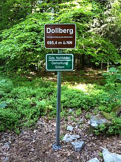
The Dollberg is a mountain in the Dollberge range in central Germany and the highest point in the state of Saarland. It is 695.4 m above sea level (NHN) and lies within the Schwarzwälder Hochwald on the boundary between the counties of Trier-Saarburg (Rhineland-Palatinate) and St. Wendel (Saarland).
The Michelsberg, at 586.1 m above sea level (NHN), is the highest point in the borough of Bad Münstereifel in the county of Euskirchen in the German state of North Rhine-Westphalia. The hill, which rises near the village of Mahlberg belongs to that part of the Eifel mountains known as the Ahr Hills (Ahreifel), and is the second highest point in the range.
The Kellerberg is a hill, 448.8 m above sea level (NHN), and the highest point of the Eifel part of the Meulenwald and of the collective municipality of Wittlich-Land. It rises near Dierscheid in the county of Bernkastel-Wittlich in the German state of Rhineland-Palatinate. At the top is the Kellerberg Observation Tower.

The Nerother Kopf is the conical hill of an extinct volcano near Neroth in the Eifel mountains. It is 651.7 m above sea level (NHN) and situated in the county of Vulkaneifel in the German state of Rhineland-Palatinate.

The Hochsimmer is a volcanic cone, 587.9 m above sea level (NHN), in the Eifel Mountains in Germany. It rises near Ettringen in the Rhineland-Palatine county of Mayen-Koblenz. At the summit is an observation tower, the Hochsimmer Tower.

The Hochstein is a volcanic cone, 563 m above sea level (NHN), in the Eifel near Obermendig in the German state of Rhineland-Palatinate and county of Mayen-Koblenz.

The Rockeskyller Kopf near Rockeskyll in the county of Vulkaneifel in the German state of Rhineland-Palatinate is a hill, 554.6 m above sea level (NHN), in the Eifel mountains. It is an extinct volcano complex from the Quaternary period, around 360,000 years old and is designated as a natural monument (ND-7233-420).
The Burberg, also called the Buerberg and Bürberg, is a hill, 528.5 m above sea level (NHN), in the Eifel mountains in Germany. It rises near Schutz in the county of Vulkaneifel in the state of Rhineland-Palatinate.
The Alfbach is a 22.3-kilometre-long (13.9 mi), orographically right-bank tributary of the Prüm in the county of Bitburg-Prüm in the German state of Rhineland-Palatinate.
The Köppel, at 540.2 m above sea level (NHN), is the second highest point in the Montabaur Heights, an elongated hill ridge in the Lower Westerwald in Germany. It is second only to the nearby Alarmstange (545.2 m) and lies on the boundary between Montabaur and Dernbach in the county of Westerwaldkreis in the state of Rhineland-Palatinate. At the summit is the Köppel viewing tower.