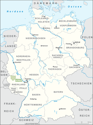
The Eifel is a low mountain range in western Germany, eastern Belgium and northern Luxembourg. It occupies parts of southwestern North Rhine-Westphalia, northwestern Rhineland-Palatinate and the southern area of the German-speaking Community of Belgium.
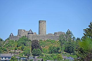
Nürburg is a town in the German district of Ahrweiler, in the state of Rhineland-Palatinate. It is also the name of the local castle, Nürburg Castle, which was built in the High Middle Ages. The name is derived from Latin niger, meaning "black", and High German burg, meaning "castle". The castle is made of basalt which usually has black color. The well-known 24-kilometre (15 mi) racing track Nürburgring is nearby.
Adenau is a town in the High Eifel in Germany. It is known as the Johanniterstadt because the Order of Saint John was based there in the Middle Ages. The town's coat of arms combines the black cross of the Electorate of Cologne with the lion of the lords of Nürburg. The northern loop of the Nürburgring lies just outside the town.

The Schneifel is a range of low mountains, up to 699.1 m above sea level (NHN), in the western part of the Eifel in Germany, near the Belgian border. It runs from Brandscheid near Prüm in a northeasterly direction to Ormont. The name Schneifel has nothing to do with the German words Schnee (snow) and Eifel. It is derived from the former dialect of this region and means something like Schneise ("swathe"). This swathe ran over the mountains. The term was "Germanised" during the Prussian era and the term Schnee-Eifel was born, albeit referring to a larger area.

Nitz is an Ortsgemeinde – a municipality belonging to a Verbandsgemeinde, a kind of collective municipality – in the Vulkaneifel district in Rhineland-Palatinate, Germany. It belongs to the Verbandsgemeinde of Kelberg, whose seat is in the like-named municipality.
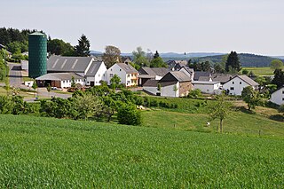
Sassen is an Ortsgemeinde – a municipality belonging to a Verbandsgemeinde, a kind of collective municipality – in the Vulkaneifel district in Rhineland-Palatinate, Germany. It belongs to the Verbandsgemeinde of Kelberg, whose seat is in the like-named municipality.
The North Eifel, the northern part of the Eifel, a low mountain range in Germany and East Belgium, comprises the following six sub-regions:

The Volcanic Eifel or Vulkan Eifel is a region in the Eifel Mountains in Germany that is defined to a large extent by its volcanic geological history. Characteristic of this volcanic field are its typical explosion crater lakes or maars, and numerous other signs of volcanic activity such as volcanic tuffs, lava streams and volcanic craters like the Laacher See. The Volcanic Eifel is still volcanically active today. One sign of this activity is the escaping gases in the Laacher See.
The German-Belgian High Fens – Eifel Nature Park, often called the North Eifel Nature Park, is a cross-border nature park with elements in the German federal states of North Rhine-Westphalia and Rhineland-Palatinate as well as the Belgian province of Liège. It has a total area of 2,485 km2 (959 sq mi).
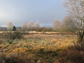
The Zitter Forest is located in the Eifel region in the German district of Euskirchen and in the Belgian province of Liège (Wallonia). Its highest point is 692 m above sea level (NN).

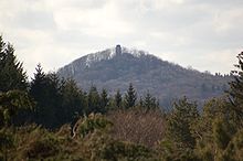
The Hohe Acht is the highest mountain in the Eifel mountains of Germany. It is located on the boundary between the districts of Ahrweiler and Mayen-Koblenz in Rhineland-Palatinate.

The Ahr Hills are a range of low mountains and hills up to 623.8 m above sea level (NHN) and 25 kilometres (16 mi) long in the Eifel region of Germany, which lie roughly southwest of Bonn on the border between the German states of North Rhine-Westphalia and Rhineland-Palatinate.
The Nürburg is a ruined hilltop castle in the German Eifel Mountains near the village of Nürburg south of Adenau in the district of Ahrweiler in the state of Rhineland-Palatinate. It stands within the famous North Loop, or Nordschleife, of the Nürburgring racing course at an altitude of 678 m (2,224 ft) on a volcanic basalt cone. It may be visited for a fee.

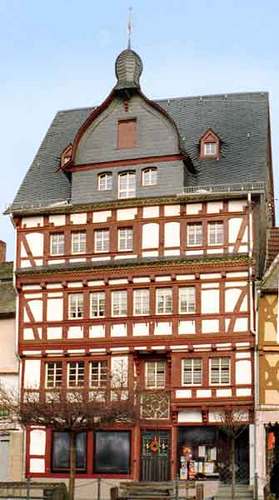
Genovevaburg is a castle standing on the southwestern side of Mayen in the German state of Rhineland-Palatinate. The castle is the symbol of Mayen and has been rebuilt several times since first being destroyed in 1689. Its name comes from a legend, according to which the seats of counts palatine, Siegfried and his wife, Genevieve of Brabant, were supposed to be on the same hill in Mayen. The earliest references linking the legend to this region date to the 17th century. Since when the castle and its bergfried, the so-called Golo Tower (Goloturm), have been linked to the legend is unknown.

Ardennes and Eifel are mountain ranges in Europe that form part of the same volcanic field and also of the Rhenish Massif. These are mountains and hills composed of slate and limestone, and of an average altitude of 400 to 500 meters, with several summits reaching the 700 meters.

The Booser Doppelmaar comprises two maars that have silted up and, today, form shallow depressions in the countryside. They lie on the territory of the village of Boos, a few hundred metres west of the village itself. The two maars were formed 10,150 to 14,160 years ago and belong to the Quaternary volcano field of the Volcanic Eifel. From a natural region perspective it lies in the south of the Hohe Acht Upland, ca. 7.8 km south of the summit of the Hohe Acht.
The Volcanic Eifel Nature Park lies in the counties of Bernkastel-Wittlich, Cochem-Zell and Vulkaneifel in the German state of Rhineland-Palatinate. The nature park, which is in the Eifel mountains, and which is also a geopark, was inaugurated on 31 May 2010 and has an area of 1,068.24 km².> Its sponsor is the Natur- und Geopark Vulkaneifel GmbH.
The Moselle Eifel forms the southeastern strip of the East Eifel to the left of the Moselle from the city of Trier downstream as far as Moselkern; in the southeast it does not reach as far as the Moselle Valley. It lies exclusively within the German state of Rhineland-Palatinate and is a truncated highland, roughly half of which is forested.

The Hochsimmer is a volcanic cone, 587.9 m above sea level (NHN), in the Eifel Mountains in Germany. It rises near Ettringen in the Rhineland-Palatine county of Mayen-Koblenz. At the summit is an observation tower, the Hochsimmer Tower.