Hochkelberg

Last updated
Hochkelberg

Hochkelberg.jpg

The summit of the Hochkelberg seen from Gänsehals
Highest point
Elevation 674.9 m (2,214 ft) [1]
Coordinates 50°16′22″N6°57′10″E / 50.272689°N 6.952707°E / 50.272689; 6.952707 Coordinates: 50°16′22″N6°57′10″E / 50.272689°N 6.952707°E / 50.272689; 6.952707
Geography
Rhineland-Palatinate relief location map.svg
Red triangle with thick white border.svg
Hochkelberg
Parent range Eifel

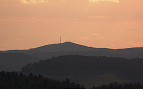
At 674.9 metres (2,214 ft) [1] the Hochkelberg is one of the ten highest mountains in the Vulkan Eifel in Germany. It is a former stratovolcano, at the southern foot of which lies the Mosbrucher Weiher, an explosion crater lake or maar. Below the summit of the Hochkelberg is a transmission tower.

Stratovolcano Tall, conical volcano built up by many layers of hardened lava and other ejecta

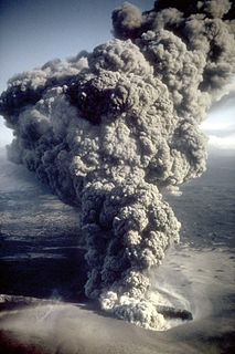
A stratovolcano, also known as a composite volcano, is a conical volcano built up by many layers (strata) of hardened lava, tephra, pumice and ash. Unlike shield volcanoes, stratovolcanoes are characterized by a steep profile with a summit crater and periodic intervals of explosive eruptions and effusive eruptions, although some have collapsed summit craters called calderas. The lava flowing from stratovolcanoes typically cools and hardens before spreading far, due to high viscosity. The magma forming this lava is often felsic, having high-to-intermediate levels of silica, with lesser amounts of less-viscous mafic magma. Extensive felsic lava flows are uncommon, but have travelled as far as 15 km (9.3 mi).

Mosbrucher Weiher

The Mosbrucher Weiher, also called the Mosbrucher Maar, is a silted up maar east of the municipal boundary of the village of Mosbruch in the county Vulkaneifel in Germany. It is located immediately at the foot of the 675-metre-high Hochkelberg, a former volcano. The floor of the maar is in the shape of an elongated oval and is about 700×500 metres in size, its upper boundary has a diameter of about 1,300 × 1,050 metres. This makes the Mosbrucher Maar the third largest of the maars in the western Eifel region. The Üßbach stream flows past and close to the Mosbrucher Weiher.

Maar Low-relief volcanic crater

A maar is a broad, low-relief volcanic crater caused by a phreatomagmatic eruption. A maar characteristically fills with water to form a relatively shallow crater lake which may also be called a maar. The name comes from a Moselle Franconian dialect word used for the circular lakes of the Daun area of Germany. Maars are shallow, flat-floored craters that scientists interpret as having formed above diatremes as a result of a violent expansion of magmatic gas or steam; deep erosion of a maar presumably would expose a diatreme. Maars range in size from 60 to 8,000 m across and from 10 to 200 m deep; most maars commonly fill with water to form natural lakes. Most maars have low rims composed of a mixture of loose fragments of volcanic rocks and rocks torn from the walls of the diatreme.

Originally the mountain which is visible today lay 200 metres below the surface. When the region was uplifted the outer layers were carried away leaving the hard basaltic core.

The slopes of the Hochkelberg are covered today with dense beech woods with a variety of species. The ruins of Roman buildings may also be seen here.

Roman Empire Period of Imperial Rome following the Roman Republic (27 BC–395 AD)

The Roman Empire was the post-Roman Republic period of the ancient Roman civilization. Ruled by emperors, it had large territorial holdings around the Mediterranean Sea in Europe, North Africa, the Middle East, and the Caucasus. From the constitutional reforms of Augustus to the military anarchy of the third century, the Empire was a principate ruled from the city of Rome. The Roman Empire was then divided between a Western Roman Empire, based in Milan and later Ravenna, and an Eastern Roman Empire, based in Nicomedia and later Constantinople, and it was ruled by multiple emperors.

Related Research Articles

Mountain A large landform that rises fairly steeply above the surrounding land over a limited area

A mountain is a large landform that rises above the surrounding land in a limited area, usually in the form of a peak. A mountain is generally steeper than a hill. Mountains are formed through tectonic forces or volcanism. These forces can locally raise the surface of the earth. Mountains erode slowly through the action of rivers, weather conditions, and glaciers. A few mountains are isolated summits, but most occur in huge mountain ranges.

Feldberg (Black Forest) Mountain in the Black Forest, Baden-Württemberg, Germany

At 1,493 metres (4,898 ft) the Feldberg in the Black Forest is the highest mountain in Baden-Württemberg, and the highest in Germany outside of the Alps. The local municipality of Feldberg was named after the mountain.

Kebnekaise Swedens highest mountain

Kebnekaise is the highest mountain in Sweden. The Kebnekaise massif, which is part of the Scandinavian Mountains, has two main peaks, of which the southern, glaciated one is highest at 2,097.5 metres (6,882 ft) above sea level as of August 2014. The northern peak is 2,096.8 metres (6,879 ft) and free of ice. Kebnekaise lies in Swedish Lapland, about 150 kilometres (93 mi) north of the Arctic Circle and west of Kiruna near the Kungsleden hiking trail between Abisko and Hemavan.

Alpine climate average weather (climate) for the regions above the tree line

Alpine climate is the average weather (climate) for the regions above the tree line. This climate is also referred to as a mountain climate or highland climate.

This is a list of the extreme points of Europe: the geographical points that are higher or farther north, south, east or west than any other location in Europe. Some of these positions are open to debate, as the definition of Europe is diverse.

Lists of mountains in Ireland Highest mountains in Ireland

These are lists of mountains and mountain ranges in Ireland. Those within Northern Ireland, or on the border, are marked with an asterisk, while the rest are within the Republic of Ireland. Where mountains are ranked by height, the definition of the "topographical prominence", used to classify the mountain, is noted. In British definitions, a height of 600 metres (1,969 ft) is required for a "mountain", whereas in Ireland, a lower threshold of 500 metres (1,640 ft) is sometimes advocated.

Jamaican Blue Mountain Coffee classification of coffee grown in the Blue Mountains of Jamaica

Jamaican Blue Mountain Coffee or Jamaica Blue Mountain Coffee is a classification of coffee grown in the Blue Mountains of Jamaica. The coffee was introduced to Jamaica in 1728.

Issus, Cilicia archaeological site

Issus is an ancient settlement on the strategic coastal plain straddling the small Pinarus river below the navigationally difficult inland mountains towering above to the east in the Turkish Province of Hatay, near the border with Syria. It can be identified with Kinet Höyük in the village of Yeṣilköy near Dörtyol in the Hatay province of Turkey. Excavations on the mound occurred between 1992 and 2012 by Bilkent University. It is most notable for being the place of no less than three decisive ancient or medieval battles each called in their own era the Battle of Issus:

  1. The Battle of Issus ; Alexander the Great of Macedonia defeated Darius III of Persia. This battle is occasionally called the First Battle of Issus, but is more generally known simply as the Battle of Issus, owing to the importance of Alexander's victory over the First Persian Empire and its impact on subsequent history of the region, including all the successor polities.
  2. Battle of Issus (194), or Second Battle of Issus — between the forces of Emperor Septimius Severus and his rival, Pescennius Niger.
  3. Battle of Issus (622), or Third Battle of Issus — between the Byzantine Empire and the Sassanid Persian Empire.
Tunnel of Eupalinos ancient tunnel in the isle of Samos

The Tunnel of Eupalinos or Eupalinian aqueduct is a tunnel of 1,036 m (3,399 ft) length in Samos, Greece, built in the 6th century BC to serve as an aqueduct. The tunnel is the second known tunnel in history which was excavated from both ends, and the first with a geometry-based approach in doing so. Today it is a popular tourist attraction.

Illawarra escarpment

The Illawarra escarpment, or officially the Illawarra Range, is the fold-created cliffs and plateau-eroded outcrop mountain range west of the Illawarra coastal plain south of Sydney, in the state of New South Wales, Australia. The range encloses the Illawarra region which stretches from Stanwell Park in the north to Kiama, Gerringong and the Shoalhaven River in the south.

Kelberg Place in Rhineland-Palatinate, Germany

Kelberg is an Ortsgemeinde – a municipality belonging to a Verbandsgemeinde, a kind of collective municipality – in the Vulkaneifel district in Rhineland-Palatinate, Germany. It belongs to the like-named Verbandsgemeinde, and is home to its seat. Kelberg is a state-recognized climatic spa.

Great Escarpment, Southern Africa Major topographical feature in southern Africa

The Great Escarpment is a major topographical feature in Africa that consists of steep slopes from the high central Southern African plateau downward in the direction of the oceans that surround Southern Africa on three sides. While it lies predominantly within the borders of South Africa, in the east it extends northwards to form the border between Mozambique and Zimbabwe, continuing on beyond the Zambezi River valley to form the Muchinga Escarpment in eastern Zambia. In the west, it continues northwards into Namibia and Angola.

Metres above mean sea level (MAMSL) or simply metres above sea level is a standard metric measurement in metres of vertical distance of a location in reference to a historic mean sea level taken as a vertical datum. Mean sea levels are affected by climate change and other factors and change over time. For this and other reasons, recorded measurements of elevation above sea level might differ from the actual elevation of a given location over sea level at a given moment.

Sassen, Germany Place in Rhineland-Palatinate, Germany

Sassen is an Ortsgemeinde – a municipality belonging to a Verbandsgemeinde, a kind of collective municipality – in the Vulkaneifel district in Rhineland-Palatinate, Germany. It belongs to the Verbandsgemeinde of Kelberg, whose seat is in the like-named municipality.

Uersfeld Place in Rhineland-Palatinate, Germany

Uersfeld is an Ortsgemeinde – a municipality belonging to a Verbandsgemeinde, a kind of collective municipality – in the Vulkaneifel district in Rhineland-Palatinate, Germany. It belongs to the Verbandsgemeinde of Kelberg, whose seat is in the like-named municipality.

Volcanic Eifel region in the Eifel Mountains in Germany, that is defined to a large extent by its volcanic geological history

The Volcanic Eifel or Vulkan Eifel is a region in the Eifel Mountains in Germany, that is defined to a large extent by its volcanic geological history. Characteristic of this volcanic field are its typical explosion crater lakes or maars, and numerous other signs of volcanic activity such as volcanic tuffs, lava streams and volcanic craters like the Laacher See. The Volcanic Eifel is still volcanically active today. One sign of this activity is the escaping gases, for example, in the Laacher See.

Hohe Acht mountain

At 746.9 m above sea level (NHN), the Hohe Acht is the highest mountain in the Eifel mountains of Germany. It is located on the boundary between the districts of Ahrweiler and Mayen-Koblenz in Rhineland-Palatinate.

References