Related Research Articles
Vulkaneifel is a district (Kreis) in the northwest of the state Rhineland-Palatinate, Germany. It is the least densely populated district in the state and the fourth most sparsely populated district in Germany. The administrative centre of the district is in Daun. Neighboring districts are Euskirchen, Ahrweiler, Mayen-Koblenz, Cochem-Zell, Bernkastel-Wittlich, and Bitburg-Prüm.

Pellenz is a Verbandsgemeinde in the district Mayen-Koblenz, in Rhineland-Palatinate, Germany. It is situated north-east of Mayen, and south of Andernach. The seat of the municipality was in Andernach, which was not part of the municipality itself and is now in Plaidt since 2017.
Maifeld is a Verbandsgemeinde in the district Mayen-Koblenz, in Rhineland-Palatinate, Germany. It is situated south-east of Mayen, and west of Koblenz. The seat of the municipality is in Polch.

Mendig is a small town in the district Mayen-Koblenz, in Rhineland-Palatinate, Germany. It is situated approximately 6 km north-east of Mayen, and 25 km west of Koblenz.
Untermosel is a former Verbandsgemeinde in the district Mayen-Koblenz, in Rhineland-Palatinate, Germany. It is situated along the lower course of the Mosel, south-west of Koblenz. The seat of the municipality was in Kobern-Gondorf. On 1 July 2014 it merged into the new Verbandsgemeinde Rhein-Mosel.

Polch is a town in the district Mayen-Koblenz, in Rhineland-Palatinate, Germany. It is part of the Verbandsgemeinde of Maifeld. It is situated east of Mayen.

Obere Aller is a Verbandsgemeinde in the Börde district in Saxony-Anhalt, Germany. Before 1 January 2010, it was a Verwaltungsgemeinschaft. It is situated approximately 30 km west of Magdeburg. It is named after the upper course of the river Aller, in its territory. The seat of the Verbandsgemeinde is in Eilsleben.
Beuren is an Ortsgemeinde – a municipality belonging to a Verbandsgemeinde, a kind of collective municipality – in the Cochem-Zell district in Rhineland-Palatinate, Germany. It belongs to the Verbandsgemeinde of Ulmen, whose seat is in the like-named town.
Kaisersesch is a Verbandsgemeinde in the district Cochem-Zell, in Rhineland-Palatinate, Germany. The seat of the Verbandsgemeinde is in Kaisersesch. On 1 July 2014 it was expanded with 8 municipalities from the former Verbandsgemeinde Treis-Karden.
Unkel is a Verbandsgemeinde in the district of Neuwied, in Rhineland-Palatinate, Germany. The seat of the Verbandsgemeinde is in Unkel.

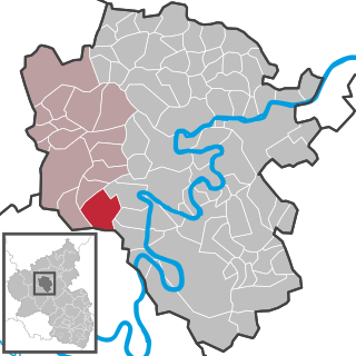
Acht is a municipality in the district of Mayen-Koblenz in Rhineland-Palatinate, western Germany. It is situated on the eastern edge of the Eifel.
Mendig is a Verbandsgemeinde in the district Mayen-Koblenz, in Rhineland-Palatinate, Germany. The seat of the municipality is in Mendig.
Rhens is a former Verbandsgemeinde in the district Mayen-Koblenz, in Rhineland-Palatinate, Germany. The seat of the municipality was in Rhens. On 1 July 2014 it merged into the new Verbandsgemeinde Rhein-Mosel.
Vallendar is a Verbandsgemeinde in the district Mayen-Koblenz, in Rhineland-Palatinate, Germany. The seat of the municipality is in Vallendar.
Weißenthurm is a Verbandsgemeinde in the district of Mayen-Koblenz, in Rhineland-Palatinate, Germany. The seat of the municipality is in Weißenthurm.

Bereborn is an Ortsgemeinde – a municipality belonging to a Verbandsgemeinde, a kind of collective municipality – in the Vulkaneifel district in Rhineland-Palatinate, Germany. It belongs to the Verbandsgemeinde of Kelberg, whose seat is in the like-named municipality.
Hachenburg is a Verbandsgemeinde in the district Westerwaldkreis, in Rhineland-Palatinate, Germany. The seat of the Verbandsgemeinde is in Hachenburg.

The Volcanic Eifel or Vulkan Eifel is a region in the Eifel Mountains in Germany that is defined to a large extent by its volcanic geological history. Characteristic of this volcanic field are its typical explosion crater lakes or maars, and numerous other signs of volcanic activity such as volcanic tuffs, lava streams and volcanic craters like the Laacher See. The Volcanic Eifel is still volcanically active today. One sign of this activity is the escaping gases in the Laacher See.
Rhein-Mosel is a Verbandsgemeinde in the district Mayen-Koblenz, in Rhineland-Palatinate, Germany. It is situated along the lower course of the river Moselle, south-west of Koblenz. The seat of the municipality is in Kobern-Gondorf. It was formed on 1 July 2014 by the merger of the former Verbandsgemeinden Untermosel and Rhens.

The Booser Doppelmaar comprises two maars that have silted up and, today, form shallow depressions in the countryside. They lie on the territory of the village of Boos, a few hundred metres west of the village itself. The two maars were formed 10,150 to 14,160 years ago and belong to the Quaternary volcano field of the Volcanic Eifel. From a natural region perspective it lies in the south of the Hohe Acht Upland, ca. 7.8 km south of the summit of the Hohe Acht.
References
| This Mayen-Koblenz location article is a stub. You can help Wikipedia by expanding it. |
Coordinates: 50°20′N7°13′E / 50.333°N 7.217°E
Verbandsgemeinden in Mayen-Koblenz | ||
|---|---|---|
 | ||