
The Moselle is a river that rises in the Vosges mountains and flows through north-eastern France and Luxembourg to western Germany. It is a left bank tributary of the Rhine, which it joins at Koblenz. A small part of Belgium is in its basin as it includes the Sauer and the Our.
Neuwied is a district (Kreis) in the north of Rhineland-Palatinate, Germany. Neighboring districts are Rhein-Sieg, Altenkirchen, Westerwaldkreis, Mayen-Koblenz, Ahrweiler.
Rhein-Lahn-Kreis is a district (Kreis) in the east of Rhineland-Palatinate, Germany. Neighboring districts are Westerwaldkreis, Limburg-Weilburg, Rheingau-Taunus, Mainz-Bingen, Rhein-Hunsrück, Mayen-Koblenz, and the district-free city Koblenz.

Mayen is a town in the Mayen-Koblenz District of the Rhineland-Palatinate Federal State of Germany, in the eastern part of the Volcanic Eifel Region. As well as the main town, additional settlements include Alzheim, Kürrenberg, Hausen-Betzing, Hausen and Nitztal. Mayen is the administrative centre of the Vordereifel ‘Collective Municipality’, although it is not part of the municipality.

Rhin-et-Moselle was a department of the First French Republic and First French Empire in present-day Germany. It was named after the rivers Rhine and Moselle. It was formed in 1797, when the left bank of the Rhine was annexed by France. Until the French occupation, its territory was divided between the Archbishopric of Cologne, the Archbishopric of Trier, and the Electorate of the Palatinate. Its territory is now part of the German states of Rhineland-Palatinate and North Rhine-Westphalia. Its capital was Koblenz.

Andernach is a town in the district of Mayen-Koblenz, in Rhineland-Palatinate, Germany, of about 30,000 inhabitants. It is situated towards the end of the Neuwied basin on the left bank of the Rhine between the former tiny fishing village of Fornich in the north and the mouth of the small river Nette in the southeast, just 13 miles (21 km) north of Koblenz, with its five external town districts: Kell, Miesenheim, Eich, Namedy, and Bad Tönisstein.
Untermosel is a former Verbandsgemeinde in the district Mayen-Koblenz, in Rhineland-Palatinate, Germany. It is situated along the lower course of the river Mosel, south-west of Koblenz. The seat of the municipality was in Kobern-Gondorf. On 1 July 2014 it merged into the new Verbandsgemeinde Rhein-Mosel.

Münstermaifeld is a town in the district Mayen-Koblenz, in Rhineland-Palatinate, Germany. It is part of the Verbandsgemeinde of Maifeld. It is situated south-east of Mayen, a few kilometres from the Moselle river and Eltz Castle. The first (B.C.) residents of the region were Celts. The old church is based on a Roman castle-tower. After the Romans, the Franks (Charlemagne) arrived in the 9th century. In the Middle Ages (1277) Münstermaifeld received town privileges and was governed by the bishop of Trier. It is one of the oldest towns in Rhineland-Palatinate and, with its 3,400 citizens, one of the smallest.
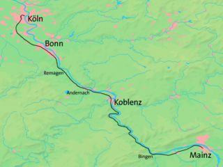
The West Rhine railway is a famously picturesque, double-track electrified railway line running for 185 km from Cologne via Bonn, Koblenz, and Bingen to Mainz. It is situated close to the western (left) bank of the river Rhine and mostly aligned to allow 160 km/h operation between Cologne and Koblenz and between Bingen and Mainz. Line speed between Koblenz and Bingen is restricted by the meandering nature of the Rhine Gorge, a UNESCO World Heritage Site.

Kobern-Gondorf is a municipality in the district of Mayen-Koblenz in Rhineland-Palatinate, western Germany. It is the seat of the Verbandsgemeinde Rhein-Mosel.

Andernach station is the transportation hub of the city of Andernach in the German state of Rhineland-Palatinate. It is a mid-sized station with thousands of passengers each day. It is currently classified by Deutsche Bahn as a category 3 station. It has four passenger platforms, three with a length of more than 280 m, and sidings and freight tracks. It is on the Left Rhine line and is the terminus of the Cross Eifel Railway (Eifelquerbahn). In addition to passenger operations, the station has container and freight operations to the east of the station, particularly serving the tin plate manufacturer, Rasselstein.

Koblenz-Lützel station is the oldest still-operating station in the city of Koblenz in the German state of Rhineland-Palatinate. It was built at the same time as the Koblenz Rhenish station, which was abandoned in 1902 with the opening of the Koblenz Central Station (Hautptbahnhof) and destroyed in World War II.
Rhein-Mosel is a Verbandsgemeinde in the district Mayen-Koblenz, in Rhineland-Palatinate, Germany. It is situated along the lower course of the river Moselle, south-west of Koblenz. The seat of the municipality is in Kobern-Gondorf. It was formed on 1 July 2014 by the merger of the former Verbandsgemeinden Untermosel and Rhens.

The Lower Moselle is the name given to the lower reaches of the Moselle river - just under 100 kilometres long - in Germany between Pünderich and the Moselle's confluence with the Rhine at Koblenz. The Lower Moselle landscape differs from that of the Middle and Upper Moselle, much of it forming a narrower valley with high and steep sides in places. On the cut banks of the river that are oriented towards the south and west, vineyards are managed, often on the tiniest, terraced strips of land on steep hillslopes.

The Middle Rhine Basin is the central landscape region of the Middle Rhine in Germany and, along with the Limburg Basin, forms one of the biggest intra-montane lowland regions within the Rhenish Massif. The basin is divided into the valley bottom of the Neuwied Basin, the Neuwied Basin Perimeter east of the Rhine and the Lower Moselle Valley west of the Rhine in the south, and the Maifeld-Pellenz Hills in the north.

Pyrmont Castle stands west of Münstermaifeld near Roes and Pillig on a slate rock outcrop above a waterfall on the Elzbach in the southern Eifel mountains in Germany. It is in the municipality of Roes in the district of Cochem-Zell.

The Niederburg at Kobern, also called the Niedernburg, Unterburg or Neue Burg, is a hill castle above the municipality of Kobern-Gondorf in the county of Mayen-Koblenz in the German state of Rhineland-Palatinate.

The Oberburg at Kobern, also called the Oberburg or Altenburg, is a hill castle above the municipality of Kobern-Gondorf in the county of Mayen-Koblenz in the German state of Rhineland-Palatinate.

Namedy Castle is located in the Rhine valley, close to the village of Namedy in Andernach, Germany. Late gothic, moated castle originally belonging to the Husmann Knights of Andernach.


