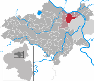
Mayen-Koblenz is a district (Kreis) in the north of Rhineland-Palatinate, Germany. Neighboring districts are Ahrweiler, Neuwied, Westerwaldkreis, district-free Koblenz, Rhein-Lahn, Rhein-Hunsrück, Cochem-Zell, and Vulkaneifel.

Mayen is a town in the Mayen-Koblenz District of the Rhineland-Palatinate Federal State of Germany, in the eastern part of the Volcanic Eifel Region. As well as the main town, additional settlements include Alzheim, Kürrenberg, Hausen-Betzing, Hausen and Nitztal. Mayen is the administrative centre of the Vordereifel ‘Collective Municipality’, although it is not part of the municipality.

Ehrenbreitstein Fortress is a fortress in the German state of Rhineland-Palatinate, on the east bank of the Rhine where it is joined by the Moselle, overlooking the town of Koblenz.

Lahnstein is a verband-free town of Rhein-Lahn-Kreis in Rhineland-Palatinate, Germany. It is situated at the confluence of the Lahn River with the Rhine, approximately 6 kilometres (3.7 mi) south of Koblenz. Lahnstein was created in 1969 by the merger of the previously independent towns of Oberlahnstein on the south side of the Lahn and Niederlahnstein on the north side.

Mendig is a small town in the district Mayen-Koblenz, in Rhineland-Palatinate, Germany. It is situated approximately 6 km north-east of Mayen, and 25 km west of Koblenz. Mendig is the seat of the Verbandsgemeinde Mendig.

Rhens is a municipality in the district Mayen-Koblenz, in Rhineland-Palatinate, Germany. It is situated on the left bank of the Rhine, approx. 10 km south of Koblenz.

Vallendar is a town in the district Mayen-Koblenz, in Rhineland-Palatinate, Germany. It is situated on the right bank of the Rhine, approx. 4 km north-east of Koblenz. Vallendar is the seat of the Verbandsgemeinde Vallendar.

Weißenthurm is a town in the district of Mayen-Koblenz, in Rhineland-Palatinate, Germany. It is situated on the left bank of the Rhine, opposite Neuwied, approximately 12 km northwest of Koblenz.
Mülheim-Kärlich is a town in the district Mayen-Koblenz, in Rhineland-Palatinate, Germany. It is part of the Verbandsgemeinde Weißenthurm. It is situated west of Koblenz, a few km from the Rhine. It is the site of the closed Mülheim-Kärlich Nuclear Power Plant.

Münstermaifeld is a town in the district Mayen-Koblenz, in Rhineland-Palatinate, Germany. It is part of the Verbandsgemeinde of Maifeld. It is situated south-east of Mayen, a few kilometres from the Moselle river and Eltz Castle. The first (B.C.) residents of the region were Celts. The old church is based on a Roman castle-tower. After the Romans, the Franks (Charlemagne) arrived in the 9th century. In the Middle Ages (1277) Münstermaifeld received town privileges and was governed by the bishop of Trier. It is one of the oldest towns in Rhineland-Palatinate and, with its 3,400 citizens, one of the smallest.

Polch is a town in the district Mayen-Koblenz, in Rhineland-Palatinate, Germany. It is part of the Verbandsgemeinde of Maifeld. It is situated east of Mayen.

Lieser is an Ortsgemeinde – a municipality belonging to a Verbandsgemeinde, a kind of collective municipality – in the Bernkastel-Wittlich district in Rhineland-Palatinate, Germany.
Bassenheim is a municipality in the district Mayen-Koblenz, in Rhineland-Palatinate, Germany. It is part of the Verbandsgemeinde Weißenthurm. It is situated 10 kilometres away from Koblenz. The municipal council consists of 20 people, 13 of them from the CDU and 7 from the SPD.

Kenn is a municipality of the Verbandsgemeinde Schweich on the banks of the Moselle in the Trier-Saarburg district, in Rhineland-Palatinate, Germany.

Kobern-Gondorf is a municipality in the district of Mayen-Koblenz in Rhineland-Palatinate, western Germany. It is the seat of the Verbandsgemeinde Rhein-Mosel.
Virneburg is a municipality in the district of Mayen-Koblenz in Rhineland-Palatinate, western Germany. Virneburg Castle is located in the village.

Ochtendung is a municipality in the district of Mayen-Koblenz in Rhineland-Palatinate, western Germany.

Spay is a municipality in the district of Mayen-Koblenz in Rhineland-Palatinate, western Germany. It is located on the left bank of the Rhine. It lies within the Rhine Gorge which became a UNESCO World Heritage Site in 2002.

Andernach station is the transportation hub of the city of Andernach in the German state of Rhineland-Palatinate. It is a mid-sized station with thousands of passengers each day. It is currently classified by Deutsche Bahn as a category 3 station. It has four passenger platforms, three with a length of more than 280 m, and sidings and freight tracks. It is on the Left Rhine line and is the terminus of the Cross Eifel Railway (Eifelquerbahn). In addition to passenger operations, the station has container and freight operations to the east of the station, particularly serving the tin plate manufacturer, Rasselstein.

The Oberburg at Kobern, also called the Oberburg or Altenburg, is a hill castle above the municipality of Kobern-Gondorf in the county of Mayen-Koblenz in the German state of Rhineland-Palatinate.


