
Rhineland-Palatinate is a western state of Germany. It covers 19,846 km2 (7,663 sq mi) and has about 4.05 million residents. It is the ninth largest and sixth most populous of the sixteen states. Mainz is the capital and largest city. Other cities are Ludwigshafen am Rhein, Koblenz, Trier, Kaiserslautern and Worms. It is bordered by North Rhine-Westphalia, Saarland, Baden-Württemberg and Hesse and by the countries France, Luxembourg and Belgium.
Mayen-Koblenz is a district (Kreis) in the north of Rhineland-Palatinate, Germany. Neighboring districts are Ahrweiler, Neuwied, Westerwaldkreis, district-free Koblenz, Rhein-Lahn, Rhein-Hunsrück, Cochem-Zell, and Vulkaneifel.

Mayen is a town in the Mayen-Koblenz District of the Rhineland-Palatinate Federal State of Germany, in the eastern part of the Volcanic Eifel Region. As well as the main town, additional settlements include Alzheim, Kürrenberg, Hausen-Betzing, Hausen and Nitztal. Mayen is the administrative centre of the Vordereifel ‘Collective Municipality’, although it is not part of the municipality.

Andernach is a town in the district of Mayen-Koblenz, in Rhineland-Palatinate, Germany, of about 30,000 inhabitants. It is situated towards the end of the Neuwied basin on the left bank of the Rhine between the former tiny fishing village of Fornich in the north and the mouth of the small river Nette in the southeast, just 13 miles (21 km) north of Koblenz, with its five external town districts: Kell, Miesenheim, Eich, Namedy, and Bad Tönisstein.

Ehrenbreitstein Fortress is a fortress in the German state of Rhineland-Palatinate, on the east bank of the Rhine where it is joined by the Moselle, overlooking the town of Koblenz.

Vallendar is a town in the district Mayen-Koblenz, in Rhineland-Palatinate, Germany. It is situated on the right bank of the Rhine, approx. 4 km north-east of Koblenz. Vallendar is the seat of the Verbandsgemeinde Vallendar.
Mülheim-Kärlich is a town in the district Mayen-Koblenz, in Rhineland-Palatinate, Germany. It is part of the Verbandsgemeinde Weißenthurm. It is situated west of Koblenz, a few km from the Rhine. It is the site of the closed Mülheim-Kärlich Nuclear Power Plant.

Münstermaifeld is a town in the district Mayen-Koblenz, in Rhineland-Palatinate, Germany. It is part of the Verbandsgemeinde of Maifeld. It is situated south-east of Mayen, a few kilometres from the Moselle river and Eltz Castle. The first (B.C.) residents of the region were Celts. The old church is based on a Roman castle-tower. After the Romans, the Franks (Charlemagne) arrived in the 9th century. In the Middle Ages (1277) Münstermaifeld received town privileges and was governed by the bishop of Trier. It is one of the oldest towns in Rhineland-Palatinate and, with its 3,400 citizens, one of the smallest.

Polch is a town in the district Mayen-Koblenz, Rhineland-Palatinate, Germany. It is part of the Verbandsgemeinde of Maifeld. It is situated east of Mayen.

Blieskastel is a city in the Saarpfalz (Saar-Palatinate) district, in Saarland, Germany which is divided into villages. It is situated on the river Blies, approximately 10 kilometres southwest of Homburg (Saar), 8 km (5 mi) west of Zweibrücken, and 20 km (12 mi) east of Saarbrücken.

Zettingen is an Ortsgemeinde – a municipality belonging to a Verbandsgemeinde, a kind of collective municipality – in the Cochem-Zell district in Rhineland-Palatinate, Germany. It belongs to the Verbandsgemeinde of Kaisersesch, whose seat is in the like-named town.

Hambuch is an Ortsgemeinde – a municipality belonging to a Verbandsgemeinde, a kind of collective municipality – in the Cochem-Zell district in Rhineland-Palatinate, Germany. It belongs to the Verbandsgemeinde of Kaisersesch, whose seat is in the like-named town.

Börsborn is an Ortsgemeinde – a municipality belonging to a Verbandsgemeinde, a kind of collective municipality – in the Kusel district in Rhineland-Palatinate, Germany. It belongs to the Verbandsgemeinde of Oberes Glantal.

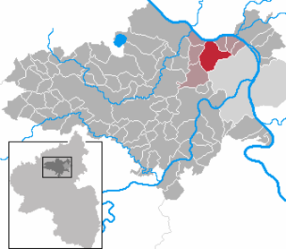
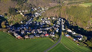
Acht is a municipality in the district of Mayen-Koblenz in Rhineland-Palatinate, western Germany. It is situated on the eastern edge of the Eifel.

Urmitz is a municipality in the district of Mayen-Koblenz in Rhineland-Palatinate, western Germany. In the 4th millennium BC it contained one of the largest fortified settlements of the time. This archaeological site has since been destroyed by modern construction.
Virneburg is a municipality in the district of Mayen-Koblenz in Rhineland-Palatinate, western Germany. Virneburg Castle is located in the village.

Ochtendung is a municipality in the district of Mayen-Koblenz in Rhineland-Palatinate, western Germany.

Leiningen is an Ortsgemeinde – a municipality belonging to a Verbandsgemeinde, a kind of collective municipality – in the Rhein-Hunsrück-Kreis (district) in Rhineland-Palatinate, Germany. It belongs to the Verbandsgemeinde Hunsrück-Mittelrhein, whose seat is in Emmelshausen.

The Niederburg at Kobern, also called the Niedernburg, Unterburg or Neue Burg, is a hill castle above the municipality of Kobern-Gondorf in the county of Mayen-Koblenz in the German state of Rhineland-Palatinate.

The Oberburg at Kobern, also called the Oberburg or Altenburg, is a hill castle above the municipality of Kobern-Gondorf in the county of Mayen-Koblenz in the German state of Rhineland-Palatinate.


