
Rhineland-Palatinate is a western state of Germany. It covers 19,846 km2 (7,663 sq mi) and has about 4.05 million residents. It is the ninth largest and sixth most populous of the sixteen states. Mainz is the capital and largest city. Other cities are Ludwigshafen am Rhein, Koblenz, Trier, Kaiserslautern and Worms. It is bordered by North Rhine-Westphalia, Saarland, Baden-Württemberg and Hesse and by the countries France, Luxembourg and Belgium.
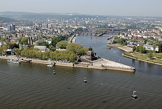
Koblenz, spelled Coblenz before 1926, is a German city on the banks of the Rhine and of the Moselle, a multi-nation tributary.
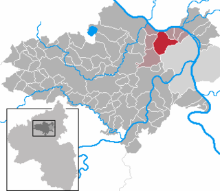
Mayen-Koblenz is a district (Kreis) in the north of Rhineland-Palatinate, Germany. Neighboring districts are Ahrweiler, Neuwied, Westerwaldkreis, district-free Koblenz, Rhein-Lahn, Rhein-Hunsrück, Cochem-Zell, and Vulkaneifel.

Mayen is a town in the Mayen-Koblenz District of the Rhineland-Palatinate Federal State of Germany, in the eastern part of the Volcanic Eifel Region. As well as the main town, additional settlements include Alzheim, Kürrenberg, Hausen-Betzing, Hausen and Nitztal. Mayen is the administrative centre of the Vordereifel ‘Collective Municipality’, although it is not part of the municipality.

Rhens is a municipality in the district Mayen-Koblenz, in Rhineland-Palatinate, Germany. It is situated on the left bank of the Rhine, approx. 10 km south of Koblenz.

Vallendar is a town in the district Mayen-Koblenz, in Rhineland-Palatinate, Germany. It is situated on the right bank of the Rhine, approx. 4 km north-east of Koblenz. Vallendar is the seat of the Verbandsgemeinde Vallendar.

Weißenthurm is a town in the district of Mayen-Koblenz, in Rhineland-Palatinate, Germany. It is situated on the left bank of the Rhine, opposite Neuwied, approximately 12 km northwest of Koblenz.

Braubach is a municipality in the Rhein-Lahn-Kreis, in Rhineland-Palatinate, Germany. It is situated on the right bank of the Rhine, approx. 10 km southeast of Koblenz. Braubach has assorted medieval architecture intact, including portions of the town wall, half-timbered buildings, and castle Marksburg on the hill above.
Mülheim-Kärlich is a town in the district Mayen-Koblenz, in Rhineland-Palatinate, Germany. It is part of the Verbandsgemeinde Weißenthurm. It is situated west of Koblenz, a few km from the Rhine. It is the site of the closed Mülheim-Kärlich Nuclear Power Plant.

Münstermaifeld is a town in the district Mayen-Koblenz, in Rhineland-Palatinate, Germany. It is part of the Verbandsgemeinde of Maifeld. It is situated south-east of Mayen, a few kilometres from the Moselle river and Eltz Castle. The first (B.C.) residents of the region were Celts. The old church is based on a Roman castle-tower. After the Romans, the Franks (Charlemagne) arrived in the 9th century. In the Middle Ages (1277) Münstermaifeld received town privileges and was governed by the bishop of Trier. It is one of the oldest towns in Rhineland-Palatinate and, with its 3,400 citizens, one of the smallest.

Alken is a municipality in the district of Mayen-Koblenz in Rhineland-Palatinate, western Germany.

Boos is a municipality in the county of Mayen-Koblenz in Rhineland-Palatinate, western Germany.

Kobern-Gondorf is a municipality in the district of Mayen-Koblenz in Rhineland-Palatinate, western Germany. It is the seat of the Verbandsgemeinde Rhein-Mosel.
Virneburg is a municipality in the district of Mayen-Koblenz in Rhineland-Palatinate, western Germany. Virneburg Castle is located in the village.

Niederfell is a small town located in the municipal association of Rhein-Mosel, which is within the rural district of Mayen-Koblenz, in the German state of Rhineland-Palatinate, near the country's western border. It is located across the Mosel River from the small town of Gondorf, about 17 kilometres (11 mi) from the city of Koblenz.

Niederwerth is a municipality in the district of Mayen-Koblenz in Rhineland-Palatinate, western Germany. It is situated on two islands in the Rhine, opposite the town Vallendar.

Saffig is a municipality in the district of Mayen-Koblenz in Rhineland-Palatinate, western Germany.

Monreal is a municipality in the district of Mayen-Koblenz in Rhineland-Palatinate, Germany.

Andernach station is the transportation hub of the city of Andernach in the German state of Rhineland-Palatinate. It is a mid-sized station with thousands of passengers each day. It is currently classified by Deutsche Bahn as a category 3 station. It has four passenger platforms, three with a length of more than 280 m, and sidings and freight tracks. It is on the Left Rhine line and is the terminus of the Cross Eifel Railway (Eifelquerbahn). In addition to passenger operations, the station has container and freight operations to the east of the station, particularly serving the tin plate manufacturer, Rasselstein.
Sayn was a small German county of the Holy Roman Empire which, during the Middle Ages, existed within what is today Rheinland-Pfalz in Germany.


