Mayen-Koblenz is a district (Kreis) in the north of Rhineland-Palatinate, Germany. Neighboring districts are Ahrweiler, Neuwied, Westerwaldkreis, district-free Koblenz, Rhein-Lahn, Rhein-Hunsrück, Cochem-Zell, and Vulkaneifel.

Rhens is a municipality in the district Mayen-Koblenz, in Rhineland-Palatinate, Germany. It is situated on the left bank of the Rhine, approx. 10 km south of Koblenz.

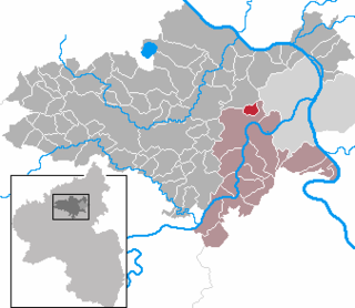
Polch is a town in the district Mayen-Koblenz, Rhineland-Palatinate, Germany. It is part of the Verbandsgemeinde of Maifeld. It is situated east of Mayen.

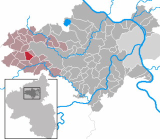
Acht is a municipality in the district of Mayen-Koblenz in Rhineland-Palatinate, western Germany. It is situated on the eastern edge of the Eifel.

Boos is a municipality in the county of Mayen-Koblenz in Rhineland-Palatinate, western Germany.

Kirchwald is a municipality in the district of Mayen-Koblenz in Rhineland-Palatinate, western Germany.

Kollig is a municipality in the district of Mayen-Koblenz in Rhineland-Palatinate, western Germany. The historic watermill Kolliger Mühle is located in the municipality.
Wolken is a municipality in the district of Mayen-Koblenz in Rhineland-Palatinate, western Germany.

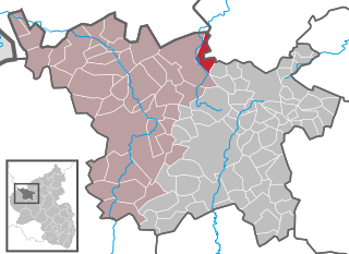
Urmitz is a municipality in the district of Mayen-Koblenz in Rhineland-Palatinate, western Germany. In the 4th millennium BC it contained one of the largest fortified settlements of the time. This archaeological site has since been destroyed by modern construction.

Welschenbach is a municipality in the district of Mayen-Koblenz in Rhineland-Palatinate, western Germany.

Naunheim is a municipality in the district of Mayen-Koblenz in Rhineland-Palatinate, western Germany.

Nörtershausen is a municipality in the district of Mayen-Koblenz in Rhineland-Palatinate, western Germany.

Plaidt is a municipality in the district of Mayen-Koblenz in Rhineland-Palatinate, western Germany.

Spay is a municipality in the district of Mayen-Koblenz in Rhineland-Palatinate, western Germany. It is located on the left bank of the Rhine. It lies within the Rhine Gorge which became a UNESCO World Heritage Site in 2002.

Thür is a municipality in the district of Mayen-Koblenz in Rhineland-Palatinate, western Germany.

Lehmen is a municipality in the district of Mayen-Koblenz in Rhineland-Palatinate, western Germany.

Löf is a municipality in the district of Mayen-Koblenz in Rhineland-Palatinate, western Germany.
Luxem is a municipality in the district of Mayen-Koblenz in Rhineland-Palatinate, western Germany.

Nitz is an Ortsgemeinde – a municipality belonging to a Verbandsgemeinde, a kind of collective municipality – in the Vulkaneifel district in Rhineland-Palatinate, Germany. It belongs to the Verbandsgemeinde of Kelberg, whose seat is in the like-named municipality.
Nohn is an Ortsgemeinde – a municipality belonging to a Verbandsgemeinde, a kind of collective municipality – in the Vulkaneifel district in Rhineland-Palatinate, Germany. It belongs to the Verbandsgemeinde of Gerolstein, whose seat is in the like-named town.


