Wernerseck Castle

Last updated
Wernerseck Castle
Kelterhausburg
Ochtendung
Burg Wernerseck2.jpg
Wernerseck Castle
Rhineland-Palatinate location map.svg
Red pog.svg
Wernerseck Castle
Germany adm location map.svg
Red pog.svg
Wernerseck Castle
Coordinates 50°22′21″N7°22′41″E / 50.372437°N 7.378091°E / 50.372437; 7.378091 Coordinates: 50°22′21″N7°22′41″E / 50.372437°N 7.378091°E / 50.372437; 7.378091
Type hill castle
CodeDE-RP
Height154 m above  sea level (NHN)
Site information
Conditionruins, largely preserved
Site history
Built1402
Materialsbasalt and slate

Wernerseck Castle (German : Burg Wernerseck), also called the Kelterhausburg, is a late medieval hill castle in the municipality of Ochtendung in the county of Mayen-Koblenz in the German state of Rhineland-Palatinate. It owes its name to its founder and lord of the castle, the Archbishop of Trier, Werner of Falkenstein (1388–1418). "Wernerseck" means "Werner's corner".

Contents

Location

September 2012 aerial photograph Burg wernerseck.jpeg
September 2012 aerial photograph
Wernerseck Castle, 2016 aerial photograph Burg Wernerseck 033x.jpg
Wernerseck Castle, 2016 aerial photograph

The ruins of the hill castle are situated above the River Nette at the foot of the Eifel mountains in the immediate vicinity of the Plaidt junction on the A 61 motorway. In the eastern part of the hill spur, on the narrowest part of which the castle was built, there was a Roman fortification in the Late Antiquity. The origin of this defensive position, which was probably conceived as a refuge fort, has been dated by coin finds to the first half of the 4th century. On the basis of pottery finds, it is assumed that the fort was used until the early 5th century. [1] :53 Similar sites from the Late Antiquity along the Nette are found at Welling, Ruitsch and on the Katzenberg near Mayen.

History

The Trier prince-elector and archbishop, Werner of Falkenstein, began building the castle in late 1401 as part of his expansion policy in the Pellenz area. Thus, the site was not in the district of Ochtendung, which belonged to Electoral Trier, but in the feudal area of the counts of Virneburg. [1] :76–77 The castle was intended to act as a border fortress, guarding it against the principality of the Archbishop of Cologne. However, the castle never fulfilled this purpose, as the borders were realigned whilst it was being built. Later the castle was used as an administrative centre. Conrad Colbe of Boppard was probably appointed as the first Amtmann (bailiff) in 1412. From the 16th century onwards, the castle was enfeoffed to the lords of Eltz, who owned it until the 19th century. From 1966 to 1969 there was a falconry at the castle. [1] :113 A preservation society has set itself the task of securing and renovating the dilapidated castle and, between summer 2006 and November 2007, the tower house was renovated.

The ruins Burg Wernerseck (aus Richtung Plaidt).jpg
The ruins

Layout

The pentagonal castle has round towers at three corners, whilst another corner forms the gate system. Its occupants lived in the 22-metre-high, four-storey, donjon (keep or tower house), which also had the normal function of a bergfried (fighting tower). It also contained the castle chapel. Access was via an elevated entrance. The tower house has unusually strong walls (2.5 metres thick) and its lower part has largely survived; the upper floors with their roof platform have become increasingly dilapidated and were repaired in 2007 by a preservation society. The castle is owned by the municipality of Ochtendung. It can be visited at any time, but can only be reached after a walk of about 2 km (from the town centre).

Eifel landscape Burg Wernerseck.jpg
Eifel landscape

Phases of construction

In the first construction phase at Wernerseck, the tower house was built as part of a simpleenceinte. The protruding bricks on the north side of the main tower, which used to join it firmly to a wall, can be seen as evidence of this. Furthermore, on the south and east side, there is a band of basalt stones in the brickwork, which could have been decoration on the outside of the castle. The curtain walls largely follow the line of the wall of the older, Ottonian castle, including its gateways. In a later extension, the surrounding wall was extended and provided with corner towers. [1] :104–107

Older castle remains

Wernerseck Castle Burg Wernerseck (Nettetal).jpg
Wernerseck Castle

The remains of an older castle, which were used in the construction of Wernerseck, can be found in various parts of the castle and which have thus survived the ravages of time. The masonry at these points differs from that of the later castle in that smaller slate stone was employed. Particularly noteworthy are the half of a gate system next to the tower house, part of the later inner gateway, and the remains of a building in the centre of the castle. Its predecessor probably followed the uninterrupted rocky hillcrest at that time and included the plateau in the area of the later outer bailey. Since there are no definitively dateable finds from the time before the new castle was built, its date of construction can only be estimated from the structural evidence. In the inner gateway, the remains of an older gateway have survived that is almost identical to that of the Waldschlössel at Klingenmünster. This suggests that the original castle should be regarded as an Ottonian build of the 10th to 11th century. There are no written records of the old castle, but it is not unreasonable to attribute its construction to the counts palatine of Laach. [1] :72–74

Related Research Articles

Mayen Town in Rhineland-Palatinate, Germany

Mayen is a town in the Mayen-Koblenz District of the Rhineland-Palatinate Federal State of Germany, in the eastern part of the Volcanic Eifel Region. As well as the main town, additional settlements include Alzheim, Kürrenberg, Hausen-Betzing, Hausen and Nitztal. Mayen is the administrative centre of the Vordereifel ‘Collective Municipality’, although it is not part of the municipality.

Daun, Germany Town in Rhineland-Palatinate, Germany

Daun is a town in the Vulkaneifel district in Rhineland-Palatinate, Germany. It is the district seat and also the seat of the Verbandsgemeinde of Daun.

Gerolstein Town in Rhineland-Palatinate, Germany

Gerolstein is a town in the Vulkaneifel district of Rhineland-Palatinate, Germany. Gerolstein is a local municipality of the Verbandsgemeinde Gerolstein. It has been approved as a Luftkurort.

Ulmen Town in Rhineland-Palatinate, Germany

Ulmen is a town in the Cochem-Zell district in Rhineland-Palatinate, Germany. It is the seat of the like-named Verbandsgemeinde – a kind of collective municipality – to which it also belongs.

Ochtendung Municipality in Rhineland-Palatinate, Germany

Ochtendung is a municipality in the district of Mayen-Koblenz in Rhineland-Palatinate, western Germany.

Volcano Park, Mayen-Koblenz

The Volcano Park in Mayen-Koblenz is a geopark in the rural district of Mayen-Koblenz in the eastern Vulkan Eifel, Germany. It was founded in 1996 and wraps around the Laacher See. Together with the Volcano Park, Brohltal/Laacher See and the Vulkan Eifel Nature and Geo-Park, it forms part of the national Eifel Volcano Land Geo-Park. The three parks are connected by the 280-kilometre-long German Volcano Route.

Lissingen Castle

Lissingen Castle is a well-preserved former moated castle dating to the 13th century. It is located on the River Kyll in Gerolstein in the administrative district of Vulkaneifel in Rhineland-Palatinate, Germany. From the outside it appears to be a single unit, but it is a double castle; an estate division in 1559 created the so-called lower castle and upper castle, which continue to have separate owners. Together with Bürresheim and Eltz, it has the distinction among castles in the Eifel of never having been destroyed.

Old Falkenstein Castle

Old Falkenstein Castle in the Harz Mountains of Germany is the castle site or burgstall of a high medieval hill castle. It lies on the territory of Falkenstein/Harz in the state of Saxony-Anhalt in the district of Harz. It was built in the 11th century A.D. and destroyed in 1115.

Genovevaburg

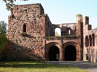
Genovevaburg is a castle standing on the southwestern side of Mayen in the German state of Rhineland-Palatinate. The castle is the symbol of Mayen and has been rebuilt several times since first being destroyed in 1689. Its name comes from a legend, according to which the seats of counts palatine, Siegfried and his wife, Genevieve of Brabant, were supposed to be on the same hill in Mayen. The earliest references linking the legend to this region date to the 17th century. Since when the castle and its bergfried, the so-called Golo Tower (Goloturm), have been linked to the legend is unknown.

Hohenfreyberg Castle

Hohenfreyberg Castle, together with Eisenberg Castle directly opposite, forms a castle group in the southern Allgäu that is visible from a long way off. It is located about four kilometres north of Pfronten in the county of Ostallgäu. The late mediaeval hilltop castle was abandoned during the Thirty Years’ War and set on fire. From 1995 to 2006 the former aristocratic seat was comprehensively made safe and conserved as part of a closely observed "example of renovation".

Falkenstein Castle (Taunus)

Falkenstein Castle, also called New Falkenstein (Neu-Falkenstein), is a ruined hill castle at 450 m above sea level (NHN) in the eponymous climatic spa of Falkenstein, a quarter of Königstein im Taunus in the county of Hochtaunuskreis in the German state of Hesse.

Welschbillig Castle

Welschbillig Castle is the ruin of a water castle in the municipality of Welschbillig in the county of Trier-Saarburg in the German state of Rhineland-Palatinate.

Thurant Castle

The ruins of the Thurant Castle stand on a wide slate hill spur above the villages of Alken on the Moselle in Germany. The castle is in the district of Mayen-Koblenz in Rhineland-Palatinate and belongs to the spur castle type. Vine gardens on the sunniest slope.

Ehrenburg (Brodenbach)

The Ehrenburg is the ruin of a spur castle at 230 m above sea level (NN) in the vicinity of Brodenbach in Germany. The castle had a very eventful history. It was built on a rocky spur in the valley of the Ehrbach, a right bank valley of the Moselle. Once the fortified heart of a small imperial barony with estates between the Lower Moselle and Middle Rhine, it is today a cultural monument that hosts numerous events.

Wildenberg Castle (Kirchzell)

Wildenberg Castle, also called the Wildenburg, is a ruined, Hohenstaufen period castle in the Odenwald hills in Germany. It is located in the parish of Preunschen in the municipality of Kirchzell, in the Lower Franconian district of Miltenberg in Bavaria.

Falkenstein Castle (Palatinate)

Falkenstein Castle is a ruined hill castle dating to the Middle Ages. It is situated above the eponymous village of Falkenstein on the Donnersberg, the highest point in the Palatinate region, which rises within the German state of Rhineland-Palatinate.

Ramstein Castle (Kordel) Castle ruins in the Kyll valley, Germany

The ruins of Ramstein Castle stand on a 182-metre-high, Bunter sandstone rock on the edge of the Meulenwald forest in the lower, steep-sided Kyll valley near Kordel in the German state of Rhineland-Palatinate. It stands 9 kilometres (5.6 mi) north of Trier and the same east of Luxembourg.

Virneburg Castle

Virneburg Castle is a ruined hill castle on a slate hill, 430 m above sea level (NHN), around which the Nitzbach stream flows. It stands above the village of Virneburg in the county of Mayen-Koblenz in the German state of Rhineland-Palatinate.

Löwenburg and Philippsburg

On a hill spur above the Eifel village of Monreal in Germany's Elzbach valley, at a height of 350 m above sea level (NHN), stand two neighbouring ruined hill castles: the Löwenburg, also called Monreal Castle, and the Philippsburg. The latter is also known locally as das Rech.

References

  1. 1 2 3 4 5 Dieter Schmidt, Günther Gries, Annette Lehnigk-Emden: Burg Wernerseck, der Burgberg in prähistorischer, spätrömischer und mittelalterlicher Zeit. In: Ochtendunger Heimatblätter. Issue 11, 2001.

Literature