Westerwaldkreis

Last updated
Westerwaldkreis
Flagge Westerwaldkreis.svg
DEU Westerwaldkreis COA.svg
Westerwaldkreis
Country Germany
State Rhineland-Palatinate
Capital Montabaur
Government
  District admin.Achim Schwickert (CDU)
Area
  Total988.73 km2 (381.75 sq mi)
Population
 (31 December 2021) [1]
  Total203,831
  Density210/km2 (530/sq mi)
Time zone UTC+01:00 (CET)
  Summer (DST) UTC+02:00 (CEST)
Vehicle registration WW
Website westerwald-kreis.de

The Westerwaldkreis ("District of Westerwald") is a district (Kreis) in the north-east of Rhineland-Palatinate, Germany. Neighbouring districts are (from north clockwise) Altenkirchen, Lahn-Dill, Limburg-Weilburg, Rhein-Lahn, the district-free city Koblenz, Mayen-Koblenz and Neuwied.

Contents

History

When the area became part of Prussia in 1866 two districts covering the area were created. The northern part was covered by the Oberwesterwaldkreis with capital in Marienberg, the Unterwesterwaldkreis with capital in Montabaur covering the southern part. In 1886 a third district was added with the Westerburg district with area from both of the other two districts. In 1932 the districts structure was reformed again, the Oberwesterwaldkreis and the Westerburg district were merged to a new Oberwesterwaldkreis with capital in Westerburg. In 1974 in another reform the districts Oberwesterwaldkreis and Unterwesterwaldkreis were merged to form the Westerwaldkreis.

Together with the neighboring Rhein-Lahn district a partnership with the English county Northamptonshire was started in 1981. As part of the partnership of Rhineland-Palatinate with Rwanda the district had a partnership with the municipality Mugesera since 1983. As in 2001 this municipality was included in the district Mirenge the partner changed.

Geography

The district is located in the Westerwald mountains. Its highest elevation is the Fuchskaute, at 657 m, the lowest is near Diez in the valley of the Gelbach, at 150 m.

Coat of arms

The bottom part of the coat of arms show basalt pillars, as the Westerwald is of volcanic origin. There are seven pillars representing the seven Verbandsgemeinden of the district which have basalt or quartzite in their area. The green band in the middle represents the forests, the jug in the upper part the traditional pottery industry in the district.

Towns and municipalities

Verbandsgemeinden
  1. Bad Marienberg 1, 2
  2. Bölsberg
  3. Dreisbach
  4. Fehl-Ritzhausen
  5. Großseifen
  6. Hahn bei Marienberg
  7. Hardt
  8. Hof
  9. Kirburg
  10. Langenbach bei Kirburg
  11. Lautzenbrücken
  12. Mörlen
  13. Neunkhausen
  14. Nisterau
  15. Nistertal
  16. Norken
  17. Stockhausen-Illfurth
  18. Unnau
  1. Alpenrod
  2. Astert
  3. Atzelgift
  4. Borod
  5. Dreifelden
  6. Gehlert
  7. Giesenhausen
  8. Hachenburg 1, 2
  9. Hattert
  10. Heimborn
  11. Heuzert
  12. Höchstenbach
  13. Kroppach
  14. Kundert
  15. Limbach
  16. Linden
  17. Lochum
  18. Luckenbach
  19. Marzhausen
  20. Merkelbach
  21. Mörsbach
  22. Mudenbach
  23. Mündersbach
  24. Müschenbach
  25. Nister
  26. Roßbach
  27. Steinebach an der Wied
  28. Stein-Wingert
  29. Streithausen
  30. Wahlrod
  31. Welkenbach
  32. Wied
  33. Winkelbach
  1. Hilgert
  2. Hillscheid
  3. Höhr-Grenzhausen 1, 2
  4. Kammerforst
  1. Boden
  2. Daubach
  3. Eitelborn
  4. Gackenbach
  5. Girod
  6. Görgeshausen
  7. Großholbach
  8. Heilberscheid
  9. Heiligenroth
  10. Holler
  11. Horbach
  12. Hübingen
  13. Kadenbach
  14. Montabaur 1, 2
  15. Nentershausen
  16. Neuhäusel
  17. Niederelbert
  18. Niedererbach
  19. Nomborn
  20. Oberelbert
  21. Ruppach-Goldhausen
  22. Simmern
  23. Stahlhofen
  24. Untershausen
  25. Welschneudorf
  1. Alsbach
  2. Breitenau
  3. Caan
  4. Deesen
  5. Hundsdorf
  6. Nauort
  7. Oberhaid
  8. Ransbach-Baumbach 1, 2
  9. Sessenbach
  10. Wirscheid
  11. Wittgert
  1. Bretthausen
  2. Elsoff
  3. Hellenhahn-Schellenberg
  4. Homberg
  5. Hüblingen
  6. Irmtraut
  7. Liebenscheid
  8. Neunkirchen
  9. Neustadt
  10. Niederroßbach
  11. Nister-Möhrendorf
  12. Oberrod
  13. Oberroßbach
  14. Rehe
  15. Rennerod 1, 2
  16. Salzburg
  17. Seck
  18. Stein-Neukirch
  19. Waigandshain
  20. Waldmühlen
  21. Westernohe
  22. Willingen
  23. Zehnhausen bei Rennerod
  1. Ellenhausen
  2. Ewighausen
  3. Freilingen
  4. Freirachdorf
  5. Goddert
  6. Hartenfels
  7. Herschbach, Selters
  8. Krümmel
  9. Marienrachdorf
  10. Maroth
  11. Maxsain
  12. Nordhofen
  13. Quirnbach
  14. Rückeroth
  15. Schenkelberg
  16. Selters 1, 2
  17. Sessenhausen
  18. Steinen
  19. Vielbach
  20. Weidenhahn
  21. Wölferlingen
  1. Arnshöfen
  2. Berod bei Wallmerod
  3. Bilkheim
  4. Dreikirchen
  5. Elbingen
  6. Ettinghausen
  7. Hahn am See
  8. Herschbach, Wallmerod
  9. Hundsangen
  10. Kuhnhöfen
  11. Mähren
  12. Meudt
  13. Molsberg
  14. Niederahr
  15. Oberahr
  16. Obererbach
  17. Salz
  18. Steinefrenz
  19. Wallmerod 1
  20. Weroth
  21. Zehnhausen bei Wallmerod
  1. Ailertchen
  2. Bellingen
  3. Berzhahn
  4. Brandscheid
  5. Enspel
  6. Gemünden
  7. Girkenroth
  8. Guckheim
  9. Halbs
  10. Härtlingen
  11. Hergenroth
  12. Höhn
  13. Kaden
  14. Kölbingen
  15. Langenhahn
  16. Pottum
  17. Rotenhain
  18. Rothenbach
  19. Stahlhofen am Wiesensee
  20. Stockum-Püschen
  21. Weltersburg
  22. Westerburg 1, 2
  23. Willmenrod
  24. Winnen
  1. Bannberscheid
  2. Dernbach
  3. Ebernhahn
  4. Helferskirchen
  5. Leuterod
  6. Mogendorf
  7. Moschheim
  8. Niedersayn
  9. Ötzingen
  10. Siershahn
  11. Staudt
  12. Wirges 1, 2
1seat of the Verbandsgemeinde; 2town

Related Research Articles

<span class="mw-page-title-main">Westerwald</span> Mountain range in Germany

The Westerwald is a low mountain range on the right bank of the river Rhine in the German federal states of Rhineland-Palatinate, Hesse and North Rhine-Westphalia. It is a part of the Rhenish Massif. Its highest elevation, at 657 m above sea level, is the Fuchskaute in the High Westerwald.

Neuwied is a district (Kreis) in the north of Rhineland-Palatinate, Germany. Neighboring districts are Rhein-Sieg, Altenkirchen, Westerwaldkreis, Mayen-Koblenz, Ahrweiler.

Rhein-Hunsrück-Kreis is a district in the middle of Rhineland-Palatinate, Germany. The neighbouring districts are Mayen-Koblenz, Rhein-Lahn, Mainz-Bingen, Bad Kreuznach, Birkenfeld, Bernkastel-Wittlich, Cochem-Zell.

Rhein-Lahn-Kreis is a district (Kreis) in the east of Rhineland-Palatinate, Germany. Neighboring districts are Westerwaldkreis, Limburg-Weilburg, Rheingau-Taunus, Mainz-Bingen, Rhein-Hunsrück, Mayen-Koblenz, and the district-free city Koblenz.

<span class="mw-page-title-main">Westerburg</span> Town in Rhineland-Palatinate, Germany

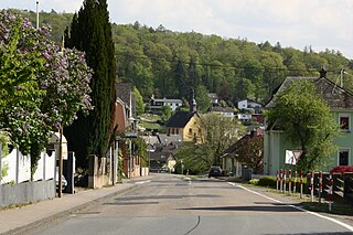
Westerburg is a small town of roughly 6,000 inhabitants in the Westerwaldkreis in Rhineland-Palatinate, Germany. The town is named after the castle built on a hill above the medieval town centre

<span class="mw-page-title-main">Steinefrenz</span> Municipality in Rhineland-Palatinate, Germany

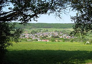
Steinefrenz is an Ortsgemeinde – a community belonging to a Verbandsgemeinde – in the Westerwaldkreis in Rhineland-Palatinate, Germany.

<span class="mw-page-title-main">Nassau, Rhineland-Palatinate</span> Town in Rhineland-Palatinate, Germany

Nassau is a town located in the German state of Rhineland-Palatinate. It lies on the lower course of the Lahn River, on the mouth of the Mühlbach, between Limburg an der Lahn and the spa town of Bad Ems, and is located in the Nassau Nature Park, surrounded by the Westerwald to the north and the Taunus to the south. The town is on the German-Dutch holiday road, the Orange Route. As of 2021, it had a population of 4,592.

<span class="mw-page-title-main">Bad Marienberg</span> Town in Rhineland-Palatinate, Germany

Bad Marienberg (Westerwald) is a town in the Westerwaldkreis in Rhineland-Palatinate, Germany, and also the seat of the like-named Verbandsgemeinde, a kind of collective municipality.

<span class="mw-page-title-main">Berzhahn</span> Municipality in Rhineland-Palatinate, Germany

Berzhahn is an Ortsgemeinde – a community belonging to a Verbandsgemeinde – in the Westerwaldkreis in Rhineland-Palatinate, Germany.

<span class="mw-page-title-main">Elsoff</span> Municipality in Rhineland-Palatinate, Germany

Elsoff is an Ortsgemeinde – a community belonging to a Verbandsgemeinde – in the Westerwaldkreis in Rhineland-Palatinate, Germany.

<span class="mw-page-title-main">Gackenbach</span> Municipality in Rhineland-Palatinate, Germany

Gackenbach is an Ortsgemeinde – a community belonging to a Verbandsgemeinde – in the Westerwaldkreis in Rhineland-Palatinate, Germany. It belongs to the Verbandsgemeinde of Montabaur, a kind of collective municipality.

<span class="mw-page-title-main">Hillscheid</span> Municipality in Rhineland-Palatinate, Germany

Hillscheid is an Ortsgemeinde – a community belonging to a Verbandsgemeinde – in the Westerwaldkreis in Rhineland-Palatinate, Germany.

<span class="mw-page-title-main">Höhn</span> Municipality in Rhineland-Palatinate, Germany

Höhn is an Ortsgemeinde – a community belonging to a Verbandsgemeinde – in the Westerwaldkreis in Rhineland-Palatinate, Germany.

<span class="mw-page-title-main">Stahlhofen</span> Municipality in Rhineland-Palatinate, Germany

Stahlhofen is an Ortsgemeinde – a community belonging to a Verbandsgemeinde – in the Westerwaldkreis in Rhineland-Palatinate, Germany. It is not to be confused with Stahlhofen am Wiesensee, another community in the same district, but in the Verbandsgemeinde of Westerburg.

<span class="mw-page-title-main">Nomborn</span> Municipality in Rhineland-Palatinate, Germany

Nomborn is an Ortsgemeinde – a community belonging to a Verbandsgemeinde – in the Westerwaldkreis in Rhineland-Palatinate, Germany.

<span class="mw-page-title-main">Oberroßbach</span> Municipality in Rhineland-Palatinate, Germany

Oberroßbach is an Ortsgemeinde – a community belonging to a Verbandsgemeinde – in the Westerwaldkreis in Rhineland-Palatinate, Germany.

<span class="mw-page-title-main">Seck</span> Municipality in Rhineland-Palatinate, Germany

Seck is an Ortsgemeinde – a community belonging to a Verbandsgemeinde – in the Westerwaldkreis in Rhineland-Palatinate, Germany.

<span class="mw-page-title-main">Westerburg station</span>

Westerburg station is a junction station on the currently closed Herborn–Montabaur railway and the still operated Limburg–Altenkirchen railway. It is in Westerburg in Westerwaldkreis, in the German state of Rhineland-Palatinate.

Montabaur was one of the five Regierungsbezirke of Rhineland-Palatinate, Germany into which the newly founded state was divided until 1968. The others were: Rheinhessen, Pfalz, Koblenz and Trier (both established by Prussia in 1816.

<span class="mw-page-title-main">Montabaur (electoral district)</span> Federal electoral district of Germany

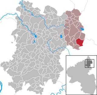
Montabaur is an electoral constituency represented in the Bundestag. It elects one member via first-past-the-post voting. Under the current constituency numbering system, it is designated as constituency 204. It is located in northern Rhineland-Palatinate, comprising the district of Westerwaldkreis and the eastern part of the Rhein-Lahn-Kreis district.

References

  1. "Bevölkerungsstand 2021, Kreise, Gemeinden, Verbandsgemeinden" (in German). Statistisches Landesamt Rheinland-Pfalz. 2022.

50°31′N7°52′E / 50.517°N 7.867°E / 50.517; 7.867