Cinder cone

Last updated

Schematic of the internal structure of a typical cinder cone Cinder cone diagram.gif
Schematic of the internal structure of a typical cinder cone

A cinder cone (or scoria cone [1] ) is a steep conical hill of loose pyroclastic fragments, such as volcanic clinkers, volcanic ash, or scoria that has been built around a volcanic vent. [2] [3] The pyroclastic fragments are formed by explosive eruptions or lava fountains from a single, typically cylindrical, vent. 
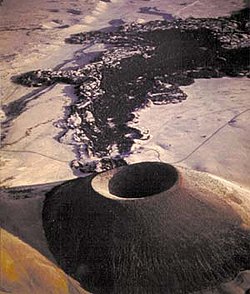
As the gas-charged lava is blown violently into the air, it breaks into small fragments that solidify and fall as either cinders, clinkers, or scoria around the vent to form a cone that often is symmetrical; with slopes between 30 and 40°; and a nearly circular ground plan. [4] Most cinder cones have a bowl-shaped crater at the summit. [2]

Contents

Mechanics of eruption

Cross-section diagram of a cinder cone or scoria cone Scoria Cone - Cross-section Diagram.jpg
Cross-section diagram of a cinder cone or scoria cone

Cinder cones range in size from tens to hundreds of meters tall [3] and often have a bowl-shaped crater at the summit. [2] They are composed of loose pyroclastic material (cinder or scoria), which distinguishes them from spatter cones , which are composed of agglomerated volcanic bombs. [5]

The pyroclastic material making up a cinder cone is usually basaltic to andesitic in composition. [6] It is often glassy and contains numerous gas bubbles "frozen" into place as magma exploded into the air and then cooled quickly. Lava fragments larger than 64 mm across, known as volcanic bombs, are also a common product of cinder cone eruptions. [3]

The growth of a cinder cone may be divided into four stages. In the first stage, a low-rimmed scoria ring forms around the erupting event. During the second stage, the rim is built up and a talus slope begins to form outside the rim. The third stage is characterized by slumping and blasts that destroy the original rim, while the fourth stage is characterized by the buildup of talus beyond the zone where cinder falls to the surface (the ballistic zone). [7]

During the waning stage of a cinder cone eruption, the magma has lost most of its gas content. This gas-depleted magma does not fountain but oozes quietly into the crater or beneath the base of the cone as lava. [8] Lava rarely issues from the top (except as a fountain) because the loose, uncemented cinders are too weak to support the pressure exerted by molten rock as it rises toward the surface through the central vent. [3] Because it contains so few gas bubbles, the molten lava is denser than the bubble-rich cinders. [8] Thus, it often burrows out along the bottom of the cinder cone, lifting the less dense cinders like corks on water, and advances outward, creating a lava flow around the cone's base. [8] When the eruption ends, a symmetrical cone of cinders sits at the center of a surrounding pad of lava. [8] If the crater is fully breached, the remaining walls form an amphitheater or horseshoe shape around the vent.

Occurrence

Cinders at a cinder cone in San Bernardino Valley, Arizona CindersFromCone.JPG
Cinders at a cinder cone in San Bernardino Valley, Arizona

Basaltic cinder cones are the most characteristic type of volcano associated with intraplate volcanism. [9] They are particularly common in association with alkaline magmatism, in which the erupted lava is enriched in sodium and potassium oxides. [10]

Cinder cones are also commonly found on the flanks of shield volcanoes, stratovolcanoes, and calderas. [3] For example, geologists have identified nearly 100 cinder cones on the flanks of Mauna Kea, a shield volcano located on the island of Hawaii. [3] Such cinder cones likely represent the final stages of activity of a mafic volcano. [11] However, most volcanic cones formed in Hawaiian-type eruptions are spatter cones rather than cinder cones, due to the fluid nature of the lava. [12]

The most famous cinder cone, Paricutin, grew out of a corn field in Mexico in 1943 from a new vent. [3] Eruptions continued for nine years, built the cone to a height of 424 meters (1,391 ft), and produced lava flows that covered 25 km2 (9.7 sq mi). [3]

The Earth's most historically active cinder cone is Cerro Negro in Nicaragua. [3] It is part of a group of four young cinder cones NW of Las Pilas volcano. Since its initial eruption in 1850, it has erupted more than 20 times, most recently in 1995 and 1999. [3]

Satellite images suggest that cinder cones occur on other terrestrial bodies in the solar system. [13] On Mars, they have been reported on the flanks of Pavonis Mons in Tharsis, [14] [15] in the region of Hydraotes Chaos [16] on the bottom of the Coprates Chasma, [17] or in the volcanic field Ulysses Colles. [18] It is also suggested that domical structures in Marius Hills (on the Moon) might represent lunar cinder cones. [19]

Effect of environmental conditions

SP Crater, an extinct cinder cone in Arizona SP Crater.jpg
SP Crater, an extinct cinder cone in Arizona

The size and shape of cinder cones depend on environmental properties as different gravity and/or atmospheric pressure might change the dispersion of ejected scoria particles. [13] For example, cinder cones on Mars seem to be more than two times wider than terrestrial analogues [18] as lower atmospheric pressure and gravity enable wider dispersion of ejected particles over a larger area. [13] [20] Therefore, it seems that erupted amount of material is not sufficient on Mars for the flank slopes to attain the angle of repose and Martian cinder cones seem to be ruled mainly by ballistic distribution and not by material redistribution on flanks as typical on Earth. [20]

Cinder cones often are highly symmetric, but strong prevailing winds at the time of eruption can cause a greater accumulation of cinder on the downwind side of the vent. [11]

Monogenetic cones

Sunset Crater, a young monogenetic cinder cone in Arizona that began forming around the year 1075 CE Sunset Crater 2.jpg
Sunset Crater, a young monogenetic cinder cone in Arizona that began forming around the year 1075 CE

Some cinder cones are monogenetic, forming from a single short eruptive episode that produces a very small volume of lava. The eruption typically last just weeks or months, but can occasionally last fifteen years or longer. [21] Parícutin in Mexico, Diamond Head, Koko Head, Punchbowl Crater, Mt Le Brun from the Coalstoun Lakes volcanic field, and some cinder cones on Mauna Kea are monogenetic cinder cones. However, not all cinder cones are monogenetic, with some ancient cinder cones showing intervals of soil formation between flows that indicate that eruptions were separated by thousands to tens of thousands of years. [21]

Monogenetic cones likely form when the rate of magma supply to a volcanic field is very low and the eruptions are spread out in space and time. This prevents any one eruption from establishing a system of "plumbing" that would provide an easy path to the surface for subsequent eruptions. Thus each eruption must find its independent path to the surface. [22] [23]

See also

Related Research Articles

<span class="mw-page-title-main">Volcano</span> Rupture in a planets crust where material escapes

A volcano is a rupture in the crust of a planetary-mass object, such as Earth, that allows hot lava, volcanic ash, and gases to escape from a magma chamber below the surface.

<span class="mw-page-title-main">Basalt</span> Magnesium- and iron-rich extrusive igneous rock

Basalt is an aphanitic (fine-grained) extrusive igneous rock formed from the rapid cooling of low-viscosity lava rich in magnesium and iron exposed at or very near the surface of a rocky planet or moon. More than 90% of all volcanic rock on Earth is basalt. Rapid-cooling, fine-grained basalt is chemically equivalent to slow-cooling, coarse-grained gabbro. The eruption of basalt lava is observed by geologists at about 20 volcanoes per year. Basalt is also an important rock type on other planetary bodies in the Solar System. For example, the bulk of the plains of Venus, which cover ~80% of the surface, are basaltic; the lunar maria are plains of flood-basaltic lava flows; and basalt is a common rock on the surface of Mars.

<span class="mw-page-title-main">Stratovolcano</span> Type of conical volcano composed of layers of lava and tephra

A stratovolcano, also known as a composite volcano, is a conical volcano built up by many layers (strata) of hardened lava and tephra. Unlike shield volcanoes, stratovolcanoes are characterized by a steep profile with a summit crater and periodic intervals of explosive eruptions and effusive eruptions, although some have collapsed summit craters called calderas. The lava flowing from stratovolcanoes typically cools and hardens before spreading far, due to high viscosity. The magma forming this lava is often felsic, having high to intermediate levels of silica, with lesser amounts of less viscous mafic magma. Extensive felsic lava flows are uncommon, but have traveled as far as 15 km (9 mi).

<span class="mw-page-title-main">Volcanic cone</span> Landform of ejecta from a volcanic vent piled up in a conical shape

Volcanic cones are among the simplest volcanic landforms. They are built by ejecta from a volcanic vent, piling up around the vent in the shape of a cone with a central crater. Volcanic cones are of different types, depending upon the nature and size of the fragments ejected during the eruption. Types of volcanic cones include stratocones, spatter cones, tuff cones, and cinder cones.

<span class="mw-page-title-main">Extrusive rock</span> Mode of igneous volcanic rock formation

Extrusive rock refers to the mode of igneous volcanic rock formation in which hot magma from inside the Earth flows out (extrudes) onto the surface as lava or explodes violently into the atmosphere to fall back as pyroclastics or tuff. In contrast, intrusive rock refers to rocks formed by magma which cools below the surface.

<span class="mw-page-title-main">Shield volcano</span> Low-profile volcano usually formed almost entirely of fluid lava flows

A shield volcano is a type of volcano named for its low profile, resembling a shield lying on the ground. It is formed by the eruption of highly fluid lava, which travels farther and forms thinner flows than the more viscous lava erupted from a stratovolcano. Repeated eruptions result in the steady accumulation of broad sheets of lava, building up the shield volcano's distinctive form.

<span class="mw-page-title-main">Mount Mazama</span> Complex volcano in the Cascade Range

Mount Mazama is a complex volcano in the western U.S. state of Oregon, in a segment of the Cascade Volcanic Arc and Cascade Range. Most of the mountain collapsed following a major eruption approximately 7,700 years ago. The volcano is in Klamath County, in the southern Cascades, 60 miles (97 km) north of the Oregon–California border. Its collapse, due to the eruption of magma emptying the underlying magma chamber, formed a caldera that holds Crater Lake. Mount Mazama originally had an elevation of 12,000 feet (3,700 m), but following its climactic eruption this was reduced to 8,157 feet (2,486 m). Crater Lake is 1,943 feet (592 m) deep, the deepest freshwater body in the U.S. and the second deepest in North America after Great Slave Lake in Canada.

<span class="mw-page-title-main">Belknap Crater</span> Shield volcano in the U.S. state of Oregon

Belknap Crater is a shield volcano in the Cascade Range in the U.S. state of Oregon. Located in Linn County, it is associated with lava fields and numerous subfeatures including the Little Belknap and South Belknap volcanic cones. It lies north of McKenzie Pass and forms part of the Mount Washington Wilderness. Belknap is not forested and most of its lava flows are not vegetated, though there is some wildlife in the area around the volcano, as well as a number of tree molds formed by its eruptive activity.

<span class="mw-page-title-main">Scoria</span> Dark vesicular volcanic rock

Scoria is a pyroclastic, highly vesicular, dark-colored volcanic rock formed by ejection from a volcano as a molten blob and cooled in the air to form discrete grains called clasts. It is typically dark in color, and basaltic or andesitic in composition. Scoria has relatively low density, as it is riddled with macroscopic ellipsoidal vesicles, but in contrast to pumice, scoria always has a specific gravity greater than 1 and sinks in water.

<span class="mw-page-title-main">Auckland volcanic field</span> Volcanic field in New Zealand

The Auckland volcanic field is an area of monogenetic volcanoes covered by much of the metropolitan area of Auckland, New Zealand's largest city, located in the North Island. The approximately 53 volcanoes in the field have produced a diverse array of maars, tuff rings, scoria cones, and lava flows. With the exception of Rangitoto, no volcano has erupted more than once, but the other eruptions lasted for various periods ranging from a few weeks to several years. Rangitoto erupted several times and recently twice; in an eruption that occurred about 600 years ago, followed by a second eruption approximately 50 years later. The field is fuelled entirely by basaltic magma, unlike the explosive subduction-driven volcanism in the central North Island, such as at Mount Ruapehu and Lake Taupō.

<span class="mw-page-title-main">Volcanic field</span> Area of Earths crust prone to localized volcanic activity

A volcanic field or crater row is an area of Earth's crust that is prone to localized volcanic activity. The type and number of volcanoes required to be called a "field" is not well-defined. Volcanic fields usually consist of clusters of up to 100 volcanoes such as cinder cones. Lava flows may also occur. They may occur as a monogenetic volcanic field or a polygenetic volcanic field.

<span class="mw-page-title-main">Pisgah Crater</span> Volcanic cinder cone in San Bernardino County, California, United States

Pisgah Crater, or Pisgah Volcano, is a young volcanic cinder cone rising above a lava plain in the Mojave Desert, between Barstow and Needles, California in San Bernardino County, California. The volcanic peak is around 2.5 miles (4.0 km) south of historic U.S. Route 66-National Old Trails Highway and of Interstate 40, and west of the town of Ludlow. The volcano had a historic elevation of 2,638 feet (804 m), but has been reduced to 2,545 feet (776 m) due to mining.

<span class="mw-page-title-main">Phreatomagmatic eruption</span> Volcanic eruption involving both steam and magma

Phreatomagmatic eruptions are volcanic eruptions resulting from interaction between magma and water. They differ from exclusively magmatic eruptions and phreatic eruptions. Unlike phreatic eruptions, the products of phreatomagmatic eruptions contain juvenile (magmatic) clasts. It is common for a large explosive eruption to have magmatic and phreatomagmatic components.

<span class="mw-page-title-main">Volcanism on Mars</span> Overview of volcanism in the geological history of Mars

Volcanic activity, or volcanism, has played a significant role in the geologic evolution of Mars. Scientists have known since the Mariner 9 mission in 1972 that volcanic features cover large portions of the Martian surface. These features include extensive lava flows, vast lava plains, and the largest known volcanoes in the Solar System. Martian volcanic features range in age from Noachian to late Amazonian, indicating that the planet has been volcanically active throughout its history, and some speculate it probably still is so today. Both Earth and Mars are large, differentiated planets built from similar chondritic materials. Many of the same magmatic processes that occur on Earth also occurred on Mars, and both planets are similar enough compositionally that the same names can be applied to their igneous rocks and minerals.

<span class="mw-page-title-main">Lava</span> Molten rock expelled by a volcano during an eruption

Lava is molten or partially molten rock (magma) that has been expelled from the interior of a terrestrial planet or a moon onto its surface. Lava may be erupted at a volcano or through a fracture in the crust, on land or underwater, usually at temperatures from 800 to 1,200 °C. The volcanic rock resulting from subsequent cooling is also often called lava.

<span class="mw-page-title-main">Ulysses Fossae</span> Fossae on Mars

The Ulysses Fossae are a group of troughs in the Tharsis quadrangle of Mars at 10.06° north latitude and 123.07° west longitude. They were named after an albedo feature name. The area contains pitted cones called Ulysses Colles which were interpreted to be possible Martian equivalents to terrestrial cinder cones.

<span class="mw-page-title-main">Ceboruco</span> Volcano in central western Mexico

Ceboruco is a dacitic stratovolcano located in Nayarit, Mexico, northwest of the Trans-Mexican Volcanic Belt. The largest eruption, the Jala Plinian eruption, was around 930 AD ±200, VEI 6, releasing 11 cubic kilometres (2.6 cu mi) of tephra. The most recent and best documented eruption from Ceboruco lasted from 1870–1875, with fumarole activity lasting well into the 20th century. The mountain features one large caldera, created during the Jala eruption, with a smaller crater nested inside that formed when the Dos Equis lava dome collapsed during the Coapales eruption around 1100 AD. Within both of these craters, are several explosive volcanic features, including scoria deposits, lava domes, and pyroclastic domes, or cinder cone volcanoes.

<span class="mw-page-title-main">Ulysses Colles</span> Colles on Mars

Ulysses Colles is an official name for conical edifices associated with flows in Ulysses Fossae in the Tharsis quadrangle of Mars. These conical edifices form small volcanic field which were interpreted as result of explosive eruptions on Mars where martian equivalents to terrestrial pyroclastic cones, cinder cones respectively, exist. This field is situated north of the shield volcanoes Biblis Patera and Ulysses Patera and it is superposed on an old, elevated window of fractured crust of Ulysses Fossae, probably of early Hesperian age, which survived flooding by younger lava flows associated with plain-style volcanism in Tharsis.

<span class="mw-page-title-main">Bayuda volcanic field</span> Volcanic field in Sudan

Bayuda volcanic field is a volcanic field in Sudan, within the Bayuda Desert. It covers a surface of about 11 by 48 kilometres and consists of a number of cinder cones as well as some maars and explosion craters. These vents have erupted 'A'ā lava flows.

<span class="mw-page-title-main">Lunar Crater volcanic field</span> Volcanic field in Nye County, Nevada

Lunar Crater volcanic field is a volcanic field in Nye County, Nevada. It lies along the Reveille and Pancake Ranges and consists of over 200 vents, mostly small volcanic cones with associated lava flows but also several maars, including one maar named Lunar Crater. Some vents have been eroded so heavily that the structures underneath the volcanoes have been exposed. Lunar Crater itself has been used as a testing ground for Mars rovers and as training ground for astronauts.

References

  1. Allaby, Michael (2013). "cinder cone". A dictionary of geology and earth sciences (Fourth ed.). Oxford: Oxford University Press. ISBN   9780199653065.
  2. 1 2 3 Poldervaart, A (1971). "Volcanicity and forms of extrusive bodies". In Green, J; Short, NM (eds.). Volcanic Landforms and Surface Features: A Photographic Atlas and Glossary. New York: Springer-Verlag. pp. 1–18. ISBN   978-3-642-65152-6.
  3. 1 2 3 4 5 6 7 8 9 10 PD-icon.svg This article incorporates public domain material from Photo glossary of volcano terms: Cinder cone. United States Geological Survey.
  4. Clarke, Hilary; Troll, Valentin R.; Carracedo, Juan Carlos (2009-03-10). "Phreatomagmatic to Strombolian eruptive activity of basaltic cinder cones: Montaña Los Erales, Tenerife, Canary Islands". Journal of Volcanology and Geothermal Research. Models and products of mafic explosive activity. 180 (2): 225–245. Bibcode:2009JVGR..180..225C. doi:10.1016/j.jvolgeores.2008.11.014. ISSN   0377-0273.
  5. Fisher, R.V.; Schmincke, H.-U. (1984). Pyroclastic rocks. Berlin: Springer-Verlag. p. 96. ISBN   3540127569.
  6. Jackson, Julia A., ed. (1997). "cinder cone". Glossary of geology (Fourth ed.). Alexandria, Virginia: American Geological Institute. ISBN   0922152349.
  7. Fisher & Schmincke 1984, p. 150.
  8. 1 2 3 4 PD-icon.svg This article incorporates public domain material from Susan S. Priest; Wendell A. Duffield; Nancy R. Riggs; Brian Poturalski; Karen Malis-Clark (2002). Red Mountain Volcano – A Spectacular and Unusual Cinder Cone in Northern Arizona. United States Geological Survey. USGS Fact Sheet 024-02. Retrieved 2012-05-18.
  9. Fisher & Schmincke 1984, p. 14.
  10. Fisher & Schmincke 1984, p. 198.
  11. 1 2 Monroe, James S.; Wicander, Reed (1992). Physical geology : exploring the Earth. St. Paul: West Pub. Co. p. 98. ISBN   0314921958.
  12. Macdonald, Gordon A.; Abbott, Agatin T.; Peterson, Frank L. (1983). Volcanoes in the sea : the geology of Hawaii (2nd ed.). Honolulu: University of Hawaii Press. pp. 16–17. ISBN   0824808320.
  13. 1 2 3 Wood, C.A. (1979). "Cinder cones on Earth, Moon, and Mars". Lunar Planet. Sci. Vol. X. pp. 1370–72. Bibcode:1979LPI....10.1370W.{{cite book}}: |journal= ignored (help)
  14. Bleacher, J.E.; Greeley, R.; Williams, D.A.; Cave, S.R.; Neukum, G. (2007). "Trends in effusive style at the Tharsis Montes, Mars, and implications for the development of the Tharsis province". J. Geophys. Res. 112 (E9): E09005. Bibcode:2007JGRE..112.9005B. doi:10.1029/2006JE002873.
  15. Keszthelyi, L.; Jaeger, W.; McEwen, A.; Tornabene, L.; Beyer, R.A.; Dundas, C.; Milazzo, M. (2008). "High Resolution Imaging Science Experiment (HiRISE) images of volcanic terrains from the first 6 months of the Mars Reconnaissance Orbiter primary science phase". J. Geophys. Res. 113 (E4): E04005. Bibcode:2008JGRE..113.4005K. CiteSeerX   10.1.1.455.1381 . doi:10.1029/2007JE002968.
  16. Meresse, S; Costard, F; Mangold, N.; Masson, Philippe; Neukum, Gerhard; the HRSC Co-I Team (2008). "Formation and evolution of the chaotic terrains by subsidence and magmatism: Hydraotes Chaos, Mars". Icarus. 194 (2): 487. Bibcode:2008Icar..194..487M. doi:10.1016/j.icarus.2007.10.023.
  17. Brož, Petr; Hauber, Ernst; Wray, James J.; Michael, Gregory (2017). "Amazonian volcanism inside Valles Marineris on Mars". Earth and Planetary Science Letters. 473: 122–130. Bibcode:2017E&PSL.473..122B. doi:10.1016/j.epsl.2017.06.003.
  18. 1 2 Brož, P; Hauber, E (2012). "A unique volcanic field in Tharsis, Mars: Pyroclastic cones as evidence for explosive eruptions". Icarus. 218 (1): 88–99. Bibcode:2012Icar..218...88B. doi:10.1016/j.icarus.2011.11.030.
  19. Lawrence, SJ; Stopar, Julie D.; Hawke, B. Ray; Greenhagen, Benjamin T.; Cahill, Joshua T. S.; Bandfield, Joshua L.; Jolliff, Bradley L.; Denevi, Brett W.; Robinson, Mark S.; Glotch, Timothy D.; Bussey, D. Benjamin J.; Spudis, Paul D.; Giguere, Thomas A.; Garry, W. Brent (2013). "LRO observations of morphology and surface roughness of volcanic cones and lobate lava flows in the Marius Hills". J. Geophys. Res. Planets. 118 (4): 615–34. Bibcode:2013JGRE..118..615L. doi: 10.1002/jgre.20060 .
  20. 1 2 Brož, Petr; Čadek, Ondřej; Hauber, Ernst; Rossi, Angelo Pio (2014). "Shape of scoria cones on Mars: Insights from numerical modeling of ballistic pathways". Earth and Planetary Science Letters. 406: 14–23. Bibcode:2014E&PSL.406...14B. doi:10.1016/j.epsl.2014.09.002.
  21. 1 2 Schmincke, Hans-Ulrich (2003). Volcanism. Berlin: Springer. pp. 99–101, 340. ISBN   978-3-540-43650-8.
  22. McGee, Lucy E.; Smith, Ian E. M.; Millet, Marc-Alban; Handley, Heather K.; Lindsay, Jan M. (October 2013). "Asthenospheric Control of Melting Processes in a Monogenetic Basaltic System: a Case Study of the Auckland Volcanic Field, New Zealand". Journal of Petrology. 54 (10): 2125–2153. doi: 10.1093/petrology/egt043 .
  23. "Monogenetic fields". Volcano World. Oregon State University. 15 April 2010. Retrieved 17 December 2021.