
Basalt is an aphanitic (fine-grained) extrusive igneous rock formed from the rapid cooling of low-viscosity lava rich in magnesium and iron exposed at or very near the surface of a rocky planet or moon. More than 90% of all volcanic rock on Earth is basalt. Rapid-cooling, fine-grained basalt is chemically equivalent to slow-cooling, coarse-grained gabbro. The eruption of basalt lava is observed by geologists at about 20 volcanoes per year. Basalt is also an important rock type on other planetary bodies in the Solar System. For example, the bulk of the plains of Venus, which cover ~80% of the surface, are basaltic; the lunar maria are plains of flood-basaltic lava flows; and basalt is a common rock on the surface of Mars.
Nephelinite is a fine-grained or aphanitic igneous rock made up almost entirely of nepheline and clinopyroxene. If olivine is present, the rock may be classified as an olivine nephelinite. Nephelinite is dark in color and may resemble basalt in hand specimen. However, basalt consists mostly of clinopyroxene (augite) and calcic plagioclase.

Intrusive rock is formed when magma penetrates existing rock, crystallizes, and solidifies underground to form intrusions, such as batholiths, dikes, sills, laccoliths, and volcanic necks.

Mount Melbourne is a 2,733-metre-high (8,967 ft) ice-covered stratovolcano in Victoria Land, Antarctica, between Wood Bay and Terra Nova Bay. It is an elongated mountain with a summit caldera filled with ice with numerous parasitic vents; a volcanic field surrounds the edifice. Mount Melbourne has a volume of about 180 cubic kilometres (43 cu mi) and consists of tephra deposits and lava flows; tephra deposits are also found encased within ice and have been used to date the last eruption of Mount Melbourne to 1892 ± 30 years. The volcano is fumarolically active.

Mount Morning is a shield volcano at the foot of the Transantarctic Mountains in Victoria Land, Antarctica. It lies 100 kilometres (62 mi) from Ross Island. Mount Morning rises to an elevation of 2,723 metres (8,934 ft) and is almost entirely mantled with snow and ice. A 4.1 by 4.9 kilometres wide summit caldera lies at the top of the volcano and several ice-free ridges such as Hurricane Ridge and Riviera Ridge emanate from the summit. A number of parasitic vents mainly in the form of cinder cones dot the mountain.

Mount Takahe is a 3,460-metre-high (11,350 ft) snow-covered shield volcano in Marie Byrd Land, Antarctica, 200 kilometres (120 mi) from the Amundsen Sea. It is a c. 30-kilometre-wide (19 mi) mountain with parasitic vents and a caldera up to 8 kilometres (5 mi) wide. Most of the volcano is formed by trachytic lava flows, but hyaloclastite is also found. Snow, ice, and glaciers cover most of Mount Takahe. With a volume of 780 km3 (200 cu mi), it is a massive volcano; the parts of the edifice that are buried underneath the West Antarctic Ice Sheet are probably even larger. It is part of the West Antarctic Rift System along with 18 other known volcanoes.

Mount Waesche is a mountain of volcanic origin at the southern end of the Executive Committee Range in Marie Byrd Land, Antarctica. It is 3,292 metres high, and stands 20 kilometres southwest of Mount Sidley, the highest volcano in Antarctica. The mountain lies southwest of the Chang Peak caldera and is largely covered with snow and glaciers, but there are rock exposures on the southern and southwestern slopes.
The Pleiades are a volcanic group in northern Victoria Land of Antarctica. It consists of youthful cones and domes with Mount Atlas/Mount Pleiones, a small stratovolcano formed by three overlapping cones, being the dominant volcano and rising 500 m (1,600 ft) above the Evans Névé plateau. Two other named cones are Alcyone Cone and Taygete Cone, the latter of which has been radiometrically dated to have erupted during the Holocene. A number of tephra layers across Antarctica have been attributed to eruptions of this volcanic group, including several that may have occurred within the last few hundred years.

Trachyandesite is an extrusive igneous rock with a composition between trachyte and andesite. It has little or no free quartz, but is dominated by sodic plagioclase and alkali feldspar. It is formed from the cooling of lava enriched in alkali metals and with an intermediate content of silica.

The Seal Nunataks are a group of 16 islands called nunataks emerging from the Larsen Ice Shelf east of Graham Land, Antarctic Peninsula. The Seal Nunataks have been described as separate volcanic vents of ages ranging from Miocene to Pleistocene. There are unconfirmed reports of Holocene volcanic activity.

The Paraná-Etendeka Large Igneous Province (PE-LIP) (or Paraná and Etendeka Plateau; or Paraná and Etendeka Province) is a large igneous province that includes both the main Paraná traps (in Paraná Basin, a South American geological basin) as well as the smaller severed portions of the flood basalts at the Etendeka traps (in northwest Namibia and southwest Angola). The original basalt flows occurred 136 to 132 million years ago. The province had a post-flow surface area of 1,000,000 square kilometres (390,000 sq mi) and an original volume projected to be in excess of 2.3 x 10⁶ km3.

The North Atlantic Igneous Province (NAIP) is a large igneous province in the North Atlantic, centered on Iceland. In the Paleogene, the province formed the Thulean Plateau, a large basaltic lava plain, which extended over at least 1.3 million km2 (500 thousand sq mi) in area and 6.6 million km3 (1.6 million cu mi) in volume. The plateau was broken up during the opening of the North Atlantic Ocean leaving remnants preserved in north Ireland, west Scotland, the Faroe Islands, northwest Iceland, east Greenland, western Norway and many of the islands located in the north eastern portion of the North Atlantic Ocean. The igneous province is the origin of the Giant's Causeway and Fingal's Cave. The province is also known as Brito–Arctic province and the portion of the province in the British Isles is also called the British Tertiary Volcanic Province or British Tertiary Igneous Province.
Hawaiite is an olivine basalt with a composition between alkali basalt and mugearite. It was first used as a name for some lavas found on the island of Hawaii.

Bimodal volcanism is the eruption of both mafic and felsic lavas from a single volcanic centre with little or no lavas of intermediate composition. This type of volcanism is normally associated with areas of extensional tectonics, particularly rifts.
The Erebus hotspot is a volcanic hotspot responsible for the high volcanic activity on Ross Island in the western Ross Sea of Antarctica. Its current eruptive zone, Mount Erebus, has erupted continuously since its discovery in 1841. Magmas of the Erebus hotspot are similar to those erupted from hotspots at the active East African Rift in eastern Africa. Mount Bird at the northernmost end of Ross Island and Mount Terror at its eastern end are large basaltic shield volcanoes that have been potassium-argon dated 3.8–4.8 and 0.8–1.8 million years old.

The Udokan Plateau is a volcanic field in Transbaikalia, Russia. It covers a surface area of 3,000 square kilometres (1,200 sq mi) northeast of Lake Baikal in North Asia. Volcanism in the Udokan Plateau included both basaltic lava flows and later individual volcanic cones. Volcanism commenced in the Miocene and continued on into the Holocene.
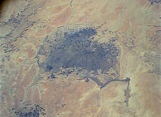
Meidob volcanic field is a Holocene volcanic field in Darfur, Sudan. It is one of several volcanic fields in Africa whose origin is explained by the activity of mantle plumes and their interaction with crustal structures. Meidob lies at the southern margin of the Sahara.

The geology of Ascension Island is the geologically young, exposed part of a large volcano, 80 kilometers west of the Mid-Atlantic Ridge. The island formed within the last six to seven million years and is primarily mafic rock with some felsic rock.

Mount Berlin is a glacier-covered volcano in Marie Byrd Land, Antarctica, 100 kilometres (62 mi) from the Amundsen Sea. It is a roughly 20-kilometre-wide (12 mi) mountain with parasitic vents that consists of two coalesced volcanoes: Berlin proper with the 2-kilometre-wide (1.2 mi) Berlin Crater and Merrem Peak with a 2.5-by-1-kilometre-wide crater, 3.5 kilometres (2.2 mi) away from Berlin. The summit of the volcano is 3,478 metres (11,411 ft) above sea level. It has a volume of 200 cubic kilometres (48 cu mi) and rises from the West Antarctic Ice Sheet. It is part of the Marie Byrd Land Volcanic Province. Trachyte is the dominant volcanic rock and occurs in the form of lava flows and pyroclastic rocks.
The alkaline magma series is a chemically distinct range of magma compositions that describes the evolution of an alkaline mafic magma into a more evolved, silica-rich end member.

