Volcanic glass is the amorphous (uncrystallized) product of rapidly cooling magma. Like all types of glass, it is a state of matter intermediate between the closely packed, highly ordered array of a crystal and the highly disordered array of liquid. Volcanic glass may refer to the interstitial material, or matrix, in an aphanitic (fine-grained) volcanic rock, or to any of several types of vitreous igneous rocks.
Landforms are categorized by characteristic physical attributes such as their creating process, shape, elevation, slope, orientation, rock exposure, and soil type.

The Garibaldi Volcanic Belt is a northwest–southeast trending volcanic chain in the Pacific Ranges of the Coast Mountains that extends from Watts Point in the south to the Ha-Iltzuk Icefield in the north. This chain of volcanoes is located in southwestern British Columbia, Canada. It forms the northernmost segment of the Cascade Volcanic Arc, which includes Mount St. Helens and Mount Baker. Most volcanoes of the Garibaldi chain are dormant stratovolcanoes and subglacial volcanoes that have been eroded by glacial ice. Less common volcanic landforms include cinder cones, volcanic plugs, lava domes and calderas. These diverse formations were created by different styles of volcanic activity, including Peléan and Plinian eruptions.

A subglacial volcano, also known as a glaciovolcano, is a volcanic form produced by subglacial eruptions or eruptions beneath the surface of a glacier or ice sheet which is then melted into a lake by the rising lava. Today they are most common in Iceland and Antarctica; older formations of this type are found also in British Columbia and Yukon Territory, Canada.

An effusive eruption is a type of volcanic eruption in which lava steadily flows out of a volcano onto the ground.

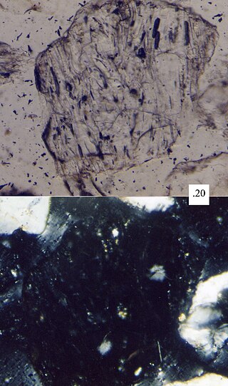
Sideromelane is a vitreous basaltic volcanic glass, usually occurring in palagonite tuff, for which it is characteristic. It is a less common form of tachylite, with which it usually occurs together; however it lacks the iron oxide crystals dispersed in the glass, and therefore appears transparent and pure, with yellow-brown color, instead of tachylite opaque black. It forms at higher temperatures and with more rapid chilling. Presence of sideromelane indicates higher temperature of the lava, and solidifying of the flow closer to the vent, probably by rapid quenching in a wet environment.

A tuya is a flat-topped, steep-sided volcano formed when lava erupts through a thick glacier or ice sheet. They are rare worldwide, being confined to regions which were covered by glaciers and had active volcanism during the same period.

Hoodoo Mountain, sometimes referred to as Hoodoo Volcano, is a potentially active stratovolcano in the Northern Interior of British Columbia, Canada. It is located 25 kilometres northeast of the Alaska–British Columbia border on the north side of the Iskut River opposite of the mouth of the Craig River. With a summit elevation of 1,850 metres and a topographic prominence of 900 metres , Hoodoo Mountain is one of many prominent peaks within the Boundary Ranges of the Coast Mountains. Its flat-topped summit is covered by an ice cap more than 100 metres thick and at least 3 kilometres in diameter. Two valley glaciers surrounding the northwestern and northeastern sides of the mountain have retreated significantly over the last hundred years. They both originate from a large icefield to the north and are the sources of two meltwater streams. These streams flow along the western and eastern sides of the volcano before draining into the Iskut River.
Subglacial eruptions, those of ice-covered volcanoes, result in the interaction of magma with ice and snow, leading to meltwater formation, jökulhlaups, and lahars. Flooding associated with meltwater is a significant hazard in some volcanic areas, including Iceland, Alaska, and parts of the Andes. Jökulhlaups have been identified as the most frequently occurring volcanic hazard in Iceland, with major events where peak discharges of meltwater can reach 10,000 – 100,000 m3/s occurring when there are large eruptions beneath glaciers.

Several types of volcanic eruptions—during which lava, tephra, and assorted gases are expelled from a volcanic vent or fissure—have been distinguished by volcanologists. These are often named after famous volcanoes where that type of behavior has been observed. Some volcanoes may exhibit only one characteristic type of eruption during a period of activity, while others may display an entire sequence of types all in one eruptive series.
Phreatomagmatic eruptions are volcanic eruptions resulting from interaction between magma and water. They differ from exclusively magmatic eruptions and phreatic eruptions. Unlike phreatic eruptions, the products of phreatomagmatic eruptions contain juvenile (magmatic) clasts. It is common for a large explosive eruption to have magmatic and phreatomagmatic components.
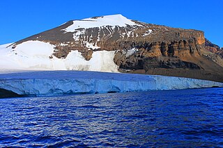
Brown Bluff is a basalt tuya on the Tabarin Peninsula of northern Antarctica. It formed in the last 1 million years as a result of subglacial eruptions within an englacial lake. The volcano's original diameter is thought to have been about 12–15 kilometers (7.5–9.3 mi) and was probably formed by a single vent. Brown Bluff is divided into four stages: pillow volcano, tuff cone, slope failure, and hyaloclastite delta; and into five structural units.

The Mount Edziza volcanic complex is a large and potentially active north-south trending complex volcano in Stikine Country, northwestern British Columbia, Canada, located 38 kilometres (24 mi) southeast of the small community of Telegraph Creek. It occupies the southeastern portion of the Tahltan Highland, an upland area of plateau and lower mountain ranges, lying east of the Boundary Ranges and south of the Inklin River, which is the east fork of the Taku River. As a volcanic complex, it consists of many types of volcanoes, including shield volcanoes, calderas, lava domes, stratovolcanoes, and cinder cones.

Vífilsfell is a hyaloclastite ridge in southwestern Iceland (Weichselian). It is 655 m high and located west of Jósepsdalur valley on the volcanic plateau of Hellisheiði. It forms the northernmost offset of the Bláfjöll mountain massif and is situated on top of the fissure system of Brennisteinsfjöll.

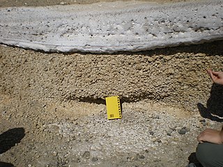
Lava deltas, similar to river deltas, form wherever sufficient sub-aerial flows of lava enter standing bodies of water. The lava cools and breaks up as it encounters the water, with the resulting fragments filling in the adjacent seabed topography such that the flow can move further offshore sub-aerially. Lava deltas are generally associated with large-scale, effusive type basaltic volcanism.

The volcanic history of the Northern Cordilleran Volcanic Province presents a record of volcanic activity in northwestern British Columbia, central Yukon and the U.S. state of easternmost Alaska. The volcanic activity lies in the northern part of the Western Cordillera of the Pacific Northwest region of North America. Extensional cracking of the North American Plate in this part of North America has existed for millions of years. Continuation of this continental rifting has fed scores of volcanoes throughout the Northern Cordilleran Volcanic Province over at least the past 20 million years and occasionally continued into geologically recent times.

The Canadian Cascade Arc, also called the Canadian Cascades, is the Canadian segment of the North American Cascade Volcanic Arc. Located entirely within the Canadian province of British Columbia, it extends from the Cascade Mountains in the south to the Coast Mountains in the north. Specifically, the southern end of the Canadian Cascades begin at the Canada–United States border. However, the specific boundaries of the northern end are not precisely known and the geology in this part of the volcanic arc is poorly understood. It is widely accepted by geologists that the Canadian Cascade Arc extends through the Pacific Ranges of the Coast Mountains. However, others have expressed concern that the volcanic arc possibly extends further north into the Kitimat Ranges, another subdivision of the Coast Mountains, and even as far north as Haida Gwaii.

The Mount Cayley volcanic field (MCVF) is a remote volcanic zone on the South Coast of British Columbia, Canada, stretching 31 km (19 mi) from the Pemberton Icefield to the Squamish River. It forms a segment of the Garibaldi Volcanic Belt, the Canadian portion of the Cascade Volcanic Arc, which extends from Northern California to southwestern British Columbia. Most of the MCVF volcanoes were formed during periods of volcanism under sheets of glacial ice throughout the last glacial period. These subglacial eruptions formed steep, flat-topped volcanoes and subglacial lava domes, most of which have been entirely exposed by deglaciation. However, at least two volcanoes predate the last glacial period and both are highly eroded. The field gets its name from Mount Cayley, a volcanic peak located at the southern end of the Powder Mountain Icefield. This icefield covers much of the central portion of the volcanic field and is one of the several glacial fields in the Pacific Ranges of the Coast Mountains.

Helgafell is a mountain on Reykjanes peninsula, Iceland. The height of the mountain is 338 m.

The Reykjanes Peninsula in southwest Iceland is the continuation of the mostly submarine Reykjanes Ridge, a part of the Mid-Atlantic Ridge, on land and reaching from Esja in the north and Hengill in the east to Reykjanestá in the west. Suðurnes is an administrative unit covering part of Reykjanes Peninsula.

