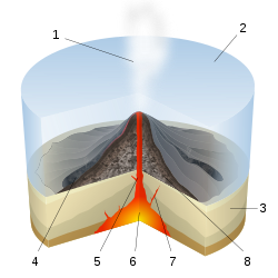
Submarine eruption

Last updated
Scheme of a submarine eruption. 1 Water vapor cloud 2 Water 3 Stratum 4 Lava flow 5 Magma conduit 6 Magma chamber 7 Dike 8 Pillow lava Submarine Eruption-numbers.svg
Scheme of a submarine eruption. 1 Water vapor cloud 2 Water 3 Stratum 4 Lava flow 5 Magma conduit 6 Magma chamber 7 Dike 8 Pillow lava
Submarine eruption at West Mata Expl2304 - Flickr - NOAA Photo Library.jpg
Submarine eruption at West Mata

Submarine eruptions are volcano eruptions which take place beneath the surface of water. These occur at constructive margins, subduction zones and within tectonic plates due to hotspots. This eruption style is far more prevalent than subaerial activity. For example, it is believed that 70 to 80% of the Earth's magma output takes place at mid-ocean ridges. [1]

Contents

Detection

Submarine eruption at Fukutoku-Okanoba Fukutoku-Okanoba Eruption 08-12-2022 2127Z to 08-13-2022 0335Z.gif
Submarine eruption at Fukutoku-Okanoba

Submarine eruptions are less studied than subaerial volcanoes due to their inaccessibility. Developments in technology mean that submarine volcanoes can now be studied in greater detail. Despite this progress, understanding is still limited. Mid ocean ridges for example are the most active volcanic systems on Earth but roughly only 5% of their length has been studied in detail. [2]

Initial knowledge of these eruptions came from volcanic rocks being recovered from the ocean floor when repairs were made to the Transatlantic telegraph cable in the 1800s. [3] More recently a variety of techniques have been used to study these eruptions with significant developments being made since 1990. These include the use of remote controlled submersibles which can conduct surveys of the ocean floor. [3] The use of hydrophone networks allows volcanic eruptions to be detected. [4] Submersibles can be sent out in response to this to record the result of the eruption. [4] Other tools have included seismic signals, acoustic waves and high resolution UAV multibeam mapping. [3]

Increasingly, eruptions at greater depths can be observed. For example, an explosive eruption at West Mata in Lau Basin at a depth of 1200 m was studied using submersibles. [5]

Controls on eruptive style

There is much variation in the style of submarine eruptions. [3] This changes with a number of variables including magma viscosity, water depth, effusion rate and volatile content. [2] Many studies highlight the effects of pressure which increases with depth. It is believed that increased pressure restricts the release of volatile gases, resulting in effusive eruptions. [6] This is not to say that explosive eruptions do not occur at depth, just that a higher volatile content is required. It has been estimated that at 500 m explosive activity associated with basalts is suppressed, while depths greater than 2300 m would be sufficient to prevent the majority of explosive activity from rhyolite lava. [1]

Shallow water eruptions

At shallow depths it is common for submarine eruptions to be explosive due to the reaction between volatiles in the magma and water which generates a significant quantity of steam. [7] These eruptions described as Surtseyan are characterised by large quantities of steam and gas and creating large amounts of pumice. [8] This activity has occurred in many locations. An example is Fukuto-Okanoba near Japan. This activity has been observed for almost a century and causes discoloured water, jets of steam and ash, and pumice is found floating in the surrounding water. [9]

Shallow eruptions can lead to the creation of islands. The most well known is Surtsey in Iceland (1963-1967). [10] Similar island building activity occurs frequently but these are often short lived. [10]

Volatile content is also significant. Magma being transported into the ocean through tunnels may see gases being exsolved before reaching the water and so the eruption is effusive. This has been seen in Hawaii.

Deep water eruption

With increased depth there is greater pressure and it is believed that this results in effusive eruptions. [11] There is a variety of evidence, however, which suggests that explosive, pyroclastic activity can occur at depth. This includes observations of Pele's hair [12] and evidence of caldera collapse. [13] This activity is thought to be common at subduction zones due to recycling of the lithosphere. [3] It is not exclusive to these plate margins, occurring at hotspots and ocean ridges. An example is Kamaʻehuakanaloa (formerly Loihi) near Hawaii where both effusive and explosive activity occurs at 2000 m depth.

Two formations associated with submarine eruptions are seamounts and pillow lavas. Pillow lavas are created due to rapid cooling of lava which forms a skin. As more magma is forced into this the skin expands creating a lobe. [11] When this fractures then lava seeps through the gap exposing hot lava to the water and again a skin forms over this: this process is then repeated. [11]

See also

Related Research Articles

<span class="mw-page-title-main">Volcano</span> Rupture in the crust of a planet that allows lava, ash, and gases to escape from below the surface

A volcano is a rupture in the crust of a planetary-mass object, such as Earth, that allows hot lava, volcanic ash, and gases to escape from a magma chamber below the surface.

<span class="mw-page-title-main">Rhyolite</span> Igneous, volcanic rock, of felsic (silica-rich) composition

Rhyolite is the most silica-rich of volcanic rocks. It is generally glassy or fine-grained (aphanitic) in texture, but may be porphyritic, containing larger mineral crystals (phenocrysts) in an otherwise fine-grained groundmass. The mineral assemblage is predominantly quartz, sanidine, and plagioclase. It is the extrusive equivalent to granite.

<span class="mw-page-title-main">Mount Tambora</span> Active stratovolcano in Indonesia

Mount Tambora, or Tomboro, is an active stratovolcano in West Nusa Tenggara, Indonesia. Located on Sumbawa in the Lesser Sunda Islands, it was formed by the active subduction zones beneath it. Before 1815, its elevation reached more than 4,300 metres high, making it one of the tallest peaks in the Indonesian archipelago.

<span class="mw-page-title-main">Stratovolcano</span> Type of conical volcano composed of layers of lava and tephra

A stratovolcano, also known as a composite volcano, is a conical volcano built up by many layers (strata) of hardened lava and tephra. Unlike shield volcanoes, stratovolcanoes are characterized by a steep profile with a summit crater and periodic intervals of explosive eruptions and effusive eruptions, although some have collapsed summit craters called calderas. The lava flowing from stratovolcanoes typically cools and hardens before spreading far, due to high viscosity. The magma forming this lava is often felsic, having high-to-intermediate levels of silica, with lesser amounts of less-viscous mafic magma. Extensive felsic lava flows are uncommon, but have travelled as far as 15 km (9 mi).

<span class="mw-page-title-main">Extrusive rock</span> Mode of igneous volcanic rock formation

Extrusive rock refers to the mode of igneous volcanic rock formation in which hot magma from inside the Earth flows out (extrudes) onto the surface as lava or explodes violently into the atmosphere to fall back as pyroclastics or tuff. In contrast, intrusive rock refers to rocks formed by magma which cools below the surface.

<span class="mw-page-title-main">Newberry Volcano</span> Shield volcano in Oregon, United States

Newberry Volcano is a large active shield-shaped stratovolcano located about 20 miles (32 km) south of Bend, Oregon, United States, 35 miles (56 km) east of the major crest of the Cascade Range, within the Newberry National Volcanic Monument. Its highest point is Paulina Peak. The largest volcano in the Cascade Volcanic Arc, Newberry has an area of 1,200 square miles (3,100 km2) when its lava flows are taken into account. From north to south, the volcano has a length of 75 miles (121 km), with a width of 27 miles (43 km) and a total volume of approximately 120 cubic miles (500 km3). It was named for the geologist and surgeon John Strong Newberry, who explored central Oregon for the Pacific Railroad Surveys in 1855. The surrounding area has been inhabited by Native American populations for more than 10,000 years.

<span class="mw-page-title-main">Mount Mazama</span> Complex volcano in the Cascade Range

Mount Mazama is a complex volcano in the state of Oregon, United States, in a segment of the Cascade Volcanic Arc and Cascade Range. Most of the mountain collapsed following a major eruption approximately 7,700 years ago. The volcano is in Klamath County, in the southern Cascades, 60 miles (97 km) north of the Oregon–California border. Its collapse, due to the eruption of magma emptying the underlying magma chamber, formed a caldera that holds Crater Lake. The mountain is in Crater Lake National Park. Mount Mazama originally had an elevation of 12,000 feet (3,700 m), but following its climactic eruption this was reduced to 8,157 feet (2,486 m). Crater Lake is 1,943 feet (592 m) deep, the deepest freshwater body in the US and the second deepest in North America after Great Slave Lake in Canada.

<span class="mw-page-title-main">Cerro Azul (Chile volcano)</span> Mountain in Curicó Province, Chile

Cerro Azul, sometimes referred to as Quizapu, is an active stratovolcano in the Maule Region of central Chile, immediately south of Descabezado Grande. Part of the South Volcanic Zone of the Andes, its summit is 3,788 meters (12,428 ft) above sea level, and is capped by a summit crater that is 500 meters (1,600 ft) wide and opens to the north. Beneath the summit, the volcano features numerous scoria cones and flank vents.

<span class="mw-page-title-main">Submarine volcano</span> Underwater vents or fissures in the Earths surface from which magma can erupt

Submarine volcanoes are underwater vents or fissures in the Earth's surface from which magma can erupt. Many submarine volcanoes are located near areas of tectonic plate formation, known as mid-ocean ridges. The volcanoes at mid-ocean ridges alone are estimated to account for 75% of the magma output on Earth. Although most submarine volcanoes are located in the depths of seas and oceans, some also exist in shallow water, and these can discharge material into the atmosphere during an eruption. The total number of submarine volcanoes is estimated to be over one million of which some 75,000 rise more than 1 kilometre (0.62 mi) above the seabed. Only 119 submarine volcanoes in Earth's oceans and seas are known to have erupted during the last 11,700 years.

<span class="mw-page-title-main">Effusive eruption</span> Type of volcanic eruption characterized by steady lava flow

An effusive eruption is a type of volcanic eruption in which lava steadily flows out of a volcano onto the ground.

<span class="mw-page-title-main">Explosive eruption</span> Type of volcanic eruption in which lava is violently expelled

In volcanology, an explosive eruption is a volcanic eruption of the most violent type. A notable example is the 1980 eruption of Mount St. Helens. Such eruptions result when sufficient gas has dissolved under pressure within a viscous magma such that expelled lava violently froths into volcanic ash when pressure is suddenly lowered at the vent. Sometimes a lava plug will block the conduit to the summit, and when this occurs, eruptions are more violent. Explosive eruptions can expel as much as 1,000 kg (2,200 lb) per second of rocks, dust, gas and pyroclastic material, averaged over the duration of eruption, that travels at several hundred meters per second as high as 20 km (12 mi) into the atmosphere. This cloud may subsequently collapse, creating a fast-moving pyroclastic flow of hot volcanic matter.

<span class="mw-page-title-main">Kuwae</span> Submarine caldera between the Epi and Tongoa islands in Vanuatu

Kuwae was a landmass that existed in the vicinity of Tongoa and was destroyed by volcanic eruption in fifteenth century, probably through caldera subsidence. The exact location of the caldera is debated. A submarine caldera, now known as Kuwae caldera that is located between the Epi and Tongoa islands is a potential candidate. Kuwae Caldera cuts through the flank of the Tavani Ruru volcano on Epi and the northwestern end of Tongoa. Another potential candidate is a proposed caldera between Tongoa and Tongariki.

<span class="mw-page-title-main">Quetrupillán</span> Mountain in Chile

Quetrupillán is a stratovolcano located in Los Ríos Region of Chile. It is situated between Villarrica and Lanín volcanoes, within Villarrica National Park. Geologically, Quetrupillán is located in a tectonic basement block between the main traces of Liquiñe-Ofqui Fault and Reigolil-Pirihueico Fault.

<span class="mw-page-title-main">Types of volcanic eruptions</span> Overview of different types of volcanic eruptions

Several types of volcanic eruptions—during which lava, tephra, and assorted gases are expelled from a volcanic vent or fissure—have been distinguished by volcanologists. These are often named after famous volcanoes where that type of behavior has been observed. Some volcanoes may exhibit only one characteristic type of eruption during a period of activity, while others may display an entire sequence of types all in one eruptive series.

<span class="mw-page-title-main">James Healy Seamount</span> Submarine volcano in New Zealands Kermadec Islands

James Healy Seamount is a submarine volcano located among the South Kermadec Ridge Seamounts south of New Zealand's Kermadec Islands. It consists of a volcanic cone that reaches a depth of 1,150 metres (3,770 ft) below sea level, two 2–2.5 kilometres (1.2–1.6 

<span class="mw-page-title-main">Phreatomagmatic eruption</span> Volcanic eruption involving both steam and magma

Phreatomagmatic eruptions are volcanic eruptions resulting from interaction between magma and water. They differ from exclusively magmatic eruptions and phreatic eruptions. Unlike phreatic eruptions, the products of phreatomagmatic eruptions contain juvenile (magmatic) clasts. It is common for a large explosive eruption to have magmatic and phreatomagmatic components.

<span class="mw-page-title-main">Silverthrone Caldera</span> Caldera in British Columbia, Canada

The Silverthrone Caldera is a potentially active caldera complex in southwestern British Columbia, Canada, located over 350 kilometres (220 mi) northwest of the city of Vancouver and about 50 kilometres (31 mi) west of Mount Waddington in the Pacific Ranges of the Coast Mountains. The caldera is one of the largest of the few calderas in western Canada, measuring about 30 kilometres (19 mi) long (north-south) and 20 kilometres (12 mi) wide (east-west). Mount Silverthrone, an eroded lava dome on the caldera's northern flank that is 2,864 metres (9,396 ft) high, may be the highest volcano in Canada.

<span class="mw-page-title-main">Sete Cidades Massif</span> Stratovolcanic complex

Sete Cidades Massif is a stratovolcanic complex, referring to a polygenetic volcano and caldera, located in western part of the island of São Miguel, in the Portuguese archipelago of the Azores. More recognizable for the Lagoa das Sete Cidades at its centre, the volcanic complex includes centuries of geomorphological structures that include lava domes, cones, lava flows and maar geomorphology that have marked its history.

<span class="mw-page-title-main">Cerro Chao</span>

Cerro Chao is a lava flow complex associated with the Cerro del León volcano in the Andes. It is the largest known Quaternary silicic volcano body and part of the most recent phase of activity in the Altiplano–Puna volcanic complex.

<span class="mw-page-title-main">Monowai (seamount)</span> Volcanic seamount north of New Zealand

Monowai Seamount is a volcanic seamount to the north of New Zealand. It is formed by a large caldera and a volcanic cone just south-southeast from the caldera. The volcanic cone rises to depths of up to 100 metres (330 ft) but its depth varies with ongoing volcanic activity, including sector collapses and the growth of lava domes. The seamount and its volcanism were discovered after 1877, but only in 1980 was it named "Monowai" after a research ship of the same name.

References

  1. 1 2 Parfitt, L. and Wilson, L. (2008) Fundamentals of Physical Volcanology, Blackwell Publishing.
  2. 1 2 Fagents, S.A., Gregg, T.K.P. and Lopes, R.M.C. (2013) Modelling Volcanic processes: the Physics and Mathematics of Volcanism, Cambridge University Press, UK.
  3. 1 2 3 4 5 Rubin, K.H., Soule, S.A., Chadwick, W.W., Farnan. D.J., Clague, A.A., Emberley. R.W., Baker, E.T., Perfit, M.R., Caress, D.W. and Dziak, R.P. (2012) Volcanic eruptions in the deep sea, Oceanography, 25(1): 142-157.
  4. 1 2 , NOAA (2013) Recent Submarine Volcanic Eruptions.
  5. , Livescience (2011) Explosive Underwater Eruptions Are Deepest Yet Seen
  6. Fransis, P. (1993) Volcanoes: A Planetary Perspective, Oxford University Press.
  7. Head, J.W. and Wilson, L. (2008) Deep submarine pyroclastic eruptions: theory and predicted landforms and deposits, Journal of Volcanology and Geothermal Research, 121: 155-193.
  8. , Smithsonian Institution National Museum of Natural History Global Volcanism Program (2013).
  9. , Volcano Discovery (2013) Fukutoku-Okanoba volcano.
  10. 1 2 Siebert, L., Simkin, T. and Kimberley, P. (2010) Volcanoes of the World, University of California Press.
  11. 1 2 3 Decker, R. and Decker, B. (1989) Volcanoes, W.H. Freeman and Company, USA.
  12. Cashman, K. V.; Sparks, R. S. J. (2013). "How volcanoes work: A 25 year perspective". Geological Society of America Bulletin. 125 (5–6): 664–690. Bibcode:2013GSAB..125..664C. doi:10.1130/B30720.1. ISSN   0016-7606.
  13. Wright, I.C. and Gamble, J.A. (1999) Southern Kermadec Submarine caldera arc volcanoes (South West Pacific): caldera formation by effusive and pyroclastic eruption, Marine Geology, 161:207-277