The geography of Antarctica is dominated by its south polar location and, thus, by ice. The Antarctic continent, located in the Earth's southern hemisphere, is centered asymmetrically around the South Pole and largely south of the Antarctic Circle. It is washed by the Southern Ocean or, depending on definition, the southern Pacific, Atlantic, and Indian Oceans. It has an area of more than 14.2 million km2. Antarctica is the largest ice desert in the world.

The Balleny Islands are a series of uninhabited islands in the Southern Ocean extending from 66°15' to 67°35'S and 162°30' to 165°00'E. The group extends for about 160 km (99 mi) in a northwest–southeast direction. The islands are heavily glaciated and of volcanic origin. Glaciers project from their slopes into the sea. The islands were formed by the so-called Balleny hotspot.

Ross Island is an island in Antarctica lying on the east side of McMurdo Sound and extending 43 nautical miles from Cape Bird in the north to Cape Armitage in the south, and a similar distance from Cape Royds in the west to Cape Crozier in the east. The island is entirely volcanic. Mount Erebus, 3,795 metres (12,451 ft), near the center, is an active volcano. Mount Terror, 3,230 metres (10,600 ft) about 20 nautical miles eastward, is an extinct volcano. Mount Bird rises to 1,765 metres (5,791 ft) just south of Cape Bird. Ross Island lies within the boundary of Ross Dependency, an area of Antarctica claimed by New Zealand.

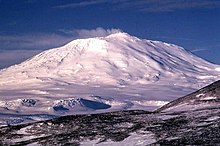
Mount Erebus is the southernmost active volcano on Earth, located on Ross Island in the Ross Dependency in Antarctica. With a summit elevation of 3,792 metres (12,441 ft), it is the second most prominent mountain in Antarctica and the second-highest volcano in Antarctica. It is the highest point on Ross Island, which is also home to three inactive volcanoes: Mount Terror, Mount Bird, and Mount Terra Nova. It makes Ross Island the sixth-highest island on Earth.

Mount Terror is an extinct volcano about 3,230 metres (10,600 ft) high on Ross Island, Antarctica, about 20 nautical miles eastward of Mount Erebus. Mount Terror was named in 1841 by polar explorer Sir James Clark Ross for his second ship, HMS Terror. The captain of Terror was Francis Crozier, a close friend of Ross for whom the nearby Cape Crozier is named.
The Transantarctic Mountains comprise a mountain range of uplifted rock in Antarctica which extends, with some interruptions, across the continent from Cape Adare in northern Victoria Land to Coats Land. These mountains divide East Antarctica and West Antarctica. They include a number of separately named mountain groups, which are often again subdivided into smaller ranges.

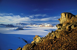
The McMurdo Sound is a sound in Antarctica, known as the southernmost passable body of water in the world, located approximately 1,300 kilometres (810 mi) from the South Pole.

The Royal Society Range is a majestic range of mountains in Victoria Land, Antarctica, rising to 4,025 metres (13,205 ft) along the west shore of McMurdo Sound between the Koettlitz, Skelton and Ferrar Glaciers. They are south of the Kukri Hills, southeast of the Quartermain Mountains, and northeast of the Worcester Range.

Mount Melbourne is a 2,733-metre-high (8,967 ft) ice-covered stratovolcano in Victoria Land, Antarctica, between Wood Bay and Terra Nova Bay. It is an elongated mountain with a summit caldera filled with ice with numerous parasitic vents; a volcanic field surrounds the edifice. Mount Melbourne has a volume of about 180 cubic kilometres (43 cu mi) and consists of tephra deposits and lava flows; tephra deposits are also found encased within ice and have been used to date the last eruption of Mount Melbourne to 1892 ± 30 years. The volcano is fumarolically active.

Mount Morning is a shield volcano at the foot of the Transantarctic Mountains in Victoria Land, Antarctica. It lies 100 kilometres (62 mi) from Ross Island. Mount Morning rises to an elevation of 2,723 metres (8,934 ft) and is almost entirely mantled with snow and ice. A 4.1 by 4.9 kilometres wide summit caldera lies at the top of the volcano and several ice-free ridges such as Hurricane Ridge and Riviera Ridge emanate from the summit. A number of parasitic vents mainly in the form of cinder cones dot the mountain.
The Pleiades are a volcanic group in northern Victoria Land of Antarctica. It consists of youthful cones and domes with Mount Atlas/Mount Pleiones, a small stratovolcano formed by three overlapping cones, being the dominant volcano and rising 500 m (1,600 ft) above the Evans Névé plateau. Two other named cones are Alcyone Cone and Taygete Cone, the latter of which has been radiometrically dated to have erupted during the Holocene. A number of tephra layers across Antarctica have been attributed to eruptions of this volcanic group, including several that may have occurred within the last few hundred years.

East Antarctica, also called Greater Antarctica, constitutes the majority (two-thirds) of the Antarctic continent, lying primarily in the Eastern Hemisphere south of the Indian Ocean, and separated from West Antarctica by the Transantarctic Mountains. It is generally greater in elevation than West Antarctica, and includes the Gamburtsev Mountain Range in the center. The geographic South Pole is located within East Antarctica.

Castle Rock is a bold rock crag, 415 metres (1,362 ft) high, standing 3 nautical miles northeast of Hut Point on the central ridge of Hut Point Peninsula, Ross Island, Antarctica. It was discovered by the British National Antarctic Expedition, 1901–04, under Robert Falcon Scott, who so named it because of its shape. The feature was a landmark for sledging parties returning from journeys to the south.

The geology of Antarctica covers the geological development of the continent through the Archean, Proterozoic and Phanerozoic eons.

Black Island, is an island in the Ross Archipelago, 12 nautical miles long, projecting through the Ross Ice Shelf to a height of 1,040 metres (3,410 ft).meters. It was discovered by the British National Antarctic Expedition and named by them for its appearance. The island is largely ice free and principally composed of black volcanic rock. The island's northernmost point is named Cape Hodgson, commemorating Thomas Vere Hodgson, one of the oldest members of the Discovery Expedition.
The Kyle Hills are a prominent group of volcanic cones, hills, ridges, and peaks that occupy the eastern part of Ross Island, Antarctica, between Mount Terror and Cape Crozier. The hills extend east–west for 8 nautical miles (15 km), rising from sea level at Cape Crozier to about 2,600 metres (8,500 ft) in Mount McIntosh at the western end of the group. Local relief of features is on the order of 200 metres (660 ft).
Daniell Peninsula is the large peninsula between Cape Daniell and Cape Jones on the coast of Victoria Land, Antarctica. It is an elongated basalt dome similar to Adare Peninsula and Hallett Peninsula and rises to 2,000 metres (6,600 ft). It is partly separated from the Victory Mountains by Whitehall Glacier, which is afloat in its lower reaches, but is joined to these mountains by the higher land in the vicinity of Mount Prior. It was named by the New Zealand Geological Survey Antarctic Expedition (NZGSAE), 1957–58, after Cape Daniell, and by analogy with the Adare and Hallett peninsulas.
Mount Rittmann is a volcano in Antarctica. Discovered in 1988–1989 by an Italian expedition, it was named after the volcanologist Alfred Rittmann (1893–1980). It features a 2 kilometres (1.2 mi) or 8 by 5 kilometres wide caldera which crops out from underneath the Aviator Glacier. The volcano was active during the Pliocene and into the Holocene, including large explosive eruptions; a major eruption occurred in 1254 CE and deposited tephra over much of Antarctica. Currently, the volcano is classified as dormant.

Mount Berlin is a glacier-covered volcano in Marie Byrd Land, Antarctica, 100 kilometres (62 mi) from the Amundsen Sea. It is a roughly 20-kilometre-wide (12 mi) mountain with parasitic vents that consists of two coalesced volcanoes: Berlin proper with the 2-kilometre-wide (1.2 mi) Berlin Crater and Merrem Peak with a 2.5-by-1-kilometre-wide crater, 3.5 kilometres (2.2 mi) away from Berlin. The summit of the volcano is 3,478 metres (11,411 ft) above sea level. It has a volume of 200 cubic kilometres (48 cu mi) and rises from the West Antarctic Ice Sheet. It is part of the Marie Byrd Land Volcanic Province. Trachyte is the dominant volcanic rock and occurs in the form of lava flows and pyroclastic rocks.