Transantarctic Mountains

Last updated

Transantarctic Mountains
Transantarctic mountain hg.jpg
The Transantarctic Mountains in northern Victoria Land near Cape Roberts
Highest point
Peak Mount Kirkpatrick
Elevation 4,528 m (14,856 ft)
Coordinates 84°20′S166°25′E / 84.333°S 166.417°E / -84.333; 166.417
Dimensions
Length3,500 km (2,200 mi)
Geography
Transantarctic mountains highlighted.jpg
Continent Antarctica
Range coordinates 85°S175°W / 85°S 175°W / -85; -175
Geology
Age of rock Cenozoic

The Transantarctic Mountains (abbreviated TAM) comprise a mountain range of uplifted rock (primarily sedimentary) in Antarctica which extends, with some interruptions, across the continent from Cape Adare in northern Victoria Land to Coats Land. These mountains divide East Antarctica and West Antarctica. They include a number of separately named mountain groups, which are often again subdivided into smaller ranges.

Contents

The range was first sighted by James Clark Ross in 1841 at what was later named the Ross Ice Shelf in his honour. It was first crossed during the British National Antarctic Expedition of 1901-1904.

Geography

Map of the Transantarctic Mountains Map of Transantarctic Mountains.jpg
Map of the Transantarctic Mountains

The mountain range stretches between the Ross Sea and the Weddell Sea, the entire width of Antarctica, hence the name. With a total length of about 3,500 km (2,000 mi), the Transantarctic Mountains are one of the longest mountain ranges on Earth. The Antarctandes are even longer, having in common with the Transantarctic Mountains the ranges from Cape Adare to the Queen Maud Mountains, but extending thence through the Whitmore Mountains and Ellsworth Mountains up the Antarctic Peninsula. The 100–300 km (60–200 mi) wide range forms the boundary between East Antarctica and West Antarctica. The East Antarctic Ice Sheet bounds the TAM along their entire length on the Eastern Hemisphere side, while the Western Hemisphere side of the range is bounded by the Ross Sea in Victoria Land from Cape Adare to McMurdo Sound, the Ross Ice Shelf from McMurdo Sound to near the Scott Glacier, and the West Antarctic Ice Sheet beyond.

The summits and dry valleys of the TAM are some of the few places in Antarctica not covered by ice, the highest of which rise more than 4,500 metres (14,800 ft) above sea level. The McMurdo Dry Valleys lie near McMurdo Sound and represent a special Antarctic phenomenon: landscapes that are snow and ice-free due to the extremely limited precipitation and ablation of ice in the valleys. The highest mountain of the TAM is the 4,528 m (14,856 ft) high Mount Kirkpatrick in the Queen Alexandra Range.

Biology

Penguins, seals, and sea birds live along the Ross Sea coastline in Victoria Land, while life in the interior of the Transantarctic Range is limited to bacteria, lichens, algae, and fungi. Forests once covered Antarctica, including plentiful Wollemi pines and southern beeches. [1] However, with the gradual cooling associated with the break-up of Gondwana, these forests gradually disappeared. [1] It is believed that the last trees on the Antarctic continent were on Transantarctic Mountains. [1]

History

The Transantarctic Mountains were first seen by Captain James Clark Ross in 1841 from the Ross Sea. The range is a natural barrier that must be crossed to reach the South Pole from the Ross Ice Shelf.

The first crossing of the Transantarctic Mountains took place during the 1902–1904 British National Antarctic Expedition at the Ross Ice Shelf. A reconnaissance party under the command of Albert Armitage reached 2,700 m (8,900 ft) altitude in 1902. The following year, a party under expedition leader Robert Falcon Scott crossed into East Antarctica at a location now known as Ferrar Glacier, named after the geologist of the expedition. They explored part of Victoria Land on the Antarctic Plateau before returning via the same glacier. In 1908, Ernest Shackleton's party crossed the mountains through the Beardmore Glacier. Scott returned to that same glacier in 1911, while Roald Amundsen crossed the range via the Axel Heiberg Glacier.

Much of the range remained unexplored until the late 1940s and 1950s, when missions such as Operation Highjump and the International Geophysical Year (IGY) made extensive use of aerial photography and concentrated on a thorough investigation of the entire continent. The name "Transantarctic Mountains" was first applied to this range in a 1960 paper [2] by geologist Warren B. Hamilton, following his IGY fieldwork. It was subsequently recommended by the Advisory Committee on Antarctic Names, a US authority on geographic names, in 1962. This purely descriptive label (in contrast to many other geographic names on Antarctica) is internationally accepted at present.

The Leverett Glacier in the Queen Maud Mountains is the planned route through the TAM for the overland supply road between McMurdo Station and Amundsen–Scott South Pole Station.

Geology

Stratigraphy of southern Victoria Land SVL Stratigraphy.svg
Stratigraphy of southern Victoria Land
Aerial view of the Dugdale Glacier in 1957 Dugdale and Murray Glacier - Antarctica.jpg
Aerial view of the Dugdale Glacier in 1957
Mount Herschel (3,335 m (10,942 ft)) in the Admiralty Mountains subrange, as seen from Cape Hallett Mt Herschel, Antarctica, Jan 2006.jpg
Mount Herschel (3,335 m (10,942 ft)) in the Admiralty Mountains subrange, as seen from Cape Hallett

The Transantarctic Mountains are considerably older than other mountain ranges of the continent, which are mainly volcanic in origin. The range was uplifted during the opening of the West Antarctic Rift System to the east, beginning about 65 million years ago in the early Cenozoic, and soon after became occupied by glaciers. [3]

The mountains consist of sedimentary layers lying upon a basement of granites and gneisses. The sedimentary layers include the Beacon Supergroup sandstones, siltstones, and coal deposited beginning in the Silurian period and continuing into the Jurassic. In many places, the Beacon Supergroup has been intruded by dikes and sills of Jurassic age Ferrar Dolerite. Many of the fossils found in Antarctica are from locations within these sedimentary formations.

Ice from the East Antarctic Ice Sheet flows through the Transantarctic Mountains via a series of outlet glaciers into the Ross Sea, Ross Ice Shelf, and West Antarctic Ice Sheet. These glaciers generally flow perpendicular to the orientation of the range and define subranges and peak groups. It has been thought that many of these outlet glaciers follow the traces of large-scale geologic faults. However, the ice flow theories will be re-evaluated in light of new data from recent ice-penetrating radar surveys which revealed the presence of three previously unknown deep subglacial valleys affecting the "mountainous subglacial topography beneath the ice divide". [4] These geographic features are likely to have a significant impact on models and calculations related to ice flow through the Transantarctic Mountain region. [4]

See also

David Glacier with the Drygalski Ice Tongue in the far distance David Cauldron.jpg
David Glacier with the Drygalski Ice Tongue in the far distance
Byrd Glacier from Landsat Byrd glacier landsat.jpg
Byrd Glacier from Landsat
The Thiel Mountains Thiel Mountains close.jpg
The Thiel Mountains

In geographic order, from the Ross Sea towards the Weddell Sea:

Victoria Land

Central TAM

Queen Maud Mountains

"Southern" TAM

Further reading

Related Research Articles

<span class="mw-page-title-main">Ross Sea</span> Deep bay of the Southern Ocean in Antarctica

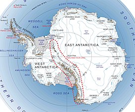
The Ross Sea is a deep bay of the Southern Ocean in Antarctica, between Victoria Land and Marie Byrd Land and within the Ross Embayment, and is the southernmost sea on Earth. It derives its name from the British explorer James Clark Ross who visited this area in 1841. To the west of the sea lies Ross Island and Victoria Land, to the east Roosevelt Island and Edward VII Peninsula in Marie Byrd Land, while the southernmost part is covered by the Ross Ice Shelf, and is about 200 miles (320 km) from the South Pole. Its boundaries and area have been defined by the New Zealand National Institute of Water and Atmospheric Research as having an area of 637,000 square kilometres (246,000 sq mi).

<span class="mw-page-title-main">Ross Island</span> Island in Ross Sea, Antarctica

Ross Island is an island in Antarctica lying on the east side of McMurdo Sound and extending 43 nautical miles from Cape Bird on the north to Cape Armitage on the south, and a like distance from Cape Royds on the west to Cape Crozier on the east. The island is entirely volcanic. Mount Erebus, 3,795 metres (12,451 ft), near the center, is an active volcano. Mount Terror, 3,230 metres (10,600 ft), about 20 nautical miles eastward, is an extinct volcano. Mount Bird rises to 1,765 metres (5,791 ft) just south of Cape Bird. Ross Island lies within the boundary of Ross Dependency, an area of Antarctica claimed by New Zealand.

<span class="mw-page-title-main">Ross Ice Shelf</span> Ice shelf in Antarctica

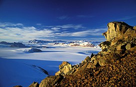
The Ross Ice Shelf is the largest ice shelf of Antarctica. It is several hundred metres thick. The nearly vertical ice front to the open sea is more than 600 kilometres (370 mi) long, and between 15 and 50 metres high above the water surface. Ninety percent of the floating ice, however, is below the water surface.

<span class="mw-page-title-main">Victoria Land</span> Region of Eastern Antarctica

Victoria Land is a region in eastern Antarctica which fronts the western side of the Ross Sea and the Ross Ice Shelf, extending southward from about 70°30'S to 78°00'S, and westward from the Ross Sea to the edge of the Antarctic Plateau. It was discovered by Captain James Clark Ross in January 1841 and named after Queen Victoria. The rocky promontory of Minna Bluff is often regarded as the southernmost point of Victoria Land, and separates the Scott Coast to the north from the Hillary Coast of the Ross Dependency to the south.

<span class="mw-page-title-main">McMurdo Sound</span> Geographic location

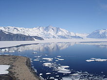
The McMurdo Sound is a sound in Antarctica, known as the southernmost passable body of water in the world, located approximately 1,300 kilometres (810 mi) from the South Pole.

<span class="mw-page-title-main">Queen Maud Mountains</span> Major feature group in the Transantarctic Mountains

The Queen Maud Mountains are a major group of mountains, ranges and subordinate features of the Transantarctic Mountains, lying between the Beardmore and Reedy Glaciers and including the area from the head of the Ross Ice Shelf to the Antarctic Plateau in Antarctica. Captain Roald Amundsen and his South Pole party ascended Axel Heiberg Glacier near the central part of this group in November 1911, naming these mountains for the Norwegian queen Maud of Wales.

<span class="mw-page-title-main">Axel Heiberg Glacier</span> Glacier in Antarctica

The Axel Heiberg Glacier in Antarctica is a valley glacier, 30 nautical miles long, descending from the high elevations of the Antarctic Plateau into the Ross Ice Shelf between the Herbert Range and Mount Don Pedro Christophersen in the Queen Maud Mountains.

<span class="mw-page-title-main">Leverett Glacier</span> Glacier in Marie Byrd Land, Antarctica

The Leverett Glacier is about 50 nautical miles (90 km) long and 3 to 4 nautical miles wide, flowing from the Antarctic Plateau to the south end of the Ross Ice Shelf through the Queen Maud Mountains. It is an important part of the South Pole Traverse from McMurdo Station to the Admundson–Scott South Pole Station, providing a route for tractors to climb from the ice shelf through the Transantarctic Mountains to the polar plateau.

<span class="mw-page-title-main">Royal Society Range</span> Mountain range in Antarctica

The Royal Society Range is a majestic range of mountains in Victoria Land, Antarctica, rising to 4,025 metres (13,205 ft) along the west shore of McMurdo Sound between the Koettlitz, Skelton and Ferrar Glaciers. They are south of the Kukri Hills, southeast of the Quartermain Mountains, and northeast of the Worcester Range.

<span class="mw-page-title-main">Ferrar Glacier</span> Glacier in Antarctica

Ferrar Glacier is a glacier in Antarctica. It is about 35 nautical miles long, flowing from the plateau of Victoria Land west of the Royal Society Range to New Harbour in McMurdo Sound. The glacier makes a right (east) turn northeast of Knobhead, where it where it is apposed, i.e., joined in Siamese-twin fashion, to Taylor Glacier. From there, it continues east along the south side of Kukri Hills to New Harbor.

<i>Discovery</i> Expedition British scientific expedition to Antarctica (1901 to 1904)

The DiscoveryExpedition of 1901–1904, known officially as the British National Antarctic Expedition, was the first official British exploration of the Antarctic regions since the voyage of James Clark Ross sixty years earlier (1839–1843). Organized on a large scale under a joint committee of the Royal Society and the Royal Geographical Society (RGS), the new expedition carried out scientific research and geographical exploration in what was then largely an untouched continent. It launched the Antarctic careers of many who would become leading figures in the Heroic Age of Antarctic Exploration, including Robert Falcon Scott who led the expedition, Ernest Shackleton, Edward Wilson, Frank Wild, Tom Crean and William Lashly.

<span class="mw-page-title-main">Scott Glacier (Transantarctic Mountains)</span> Glacier in Antarctica

The Scott Glacier is a major glacier, 120 nautical miles long, that drains the East Antarctic Ice Sheet through the Queen Maud Mountains to the Ross Ice Shelf. The Scott Glacier is one of a series of major glaciers flowing across the Transantarctic Mountains, with the Amundsen Glacier to the west and the Leverett and Reedy glaciers to the east.

<span class="mw-page-title-main">Shackleton Coast</span> Portion of the coast of Antarctica

Shackleton Coast is that portion of the coast along the west side of the Ross Ice Shelf between Cape Selborne and Airdrop Peak at the east side of Beardmore Glacier in Antarctica. Named by New Zealand Antarctic Place-Names Committee (NZ-APC) in 1961 after Sir Ernest Shackleton. He accompanied Scott on the southern journey during the Discovery expedition (1901–04) and subsequently led three Antarctic expeditions. On the British Antarctic Expedition (1907–09), Shackleton discovered the area beyond Shackleton Inlet to the Beardmore Glacier, and was the first to find a practicable route to the South Pole. Lack of food stopped him 97 miles (180 km) from his goal.

The Mulock Glacier is a large, heavily crevassed glacier which flows into the Ross Ice Shelf 40 kilometers south of the Skelton Glacier in the Ross Dependency, Antarctica.

The Nash Range is a mainly ice-covered coastal range in the Churchill Mountains of Antarctica.

Cape Lyttelton is a cape forming the southern entrance point of Shackleton Inlet, along the western edge of the Ross Ice Shelf, Antarctica.

<span class="mw-page-title-main">Index of Antarctica-related articles</span>

This is an alphabetical index of all articles related to the continent of Antarctica.

<span class="mw-page-title-main">Ross Embayment</span> Region of Antarctica

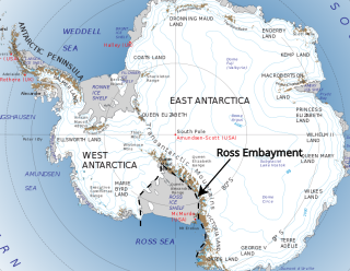
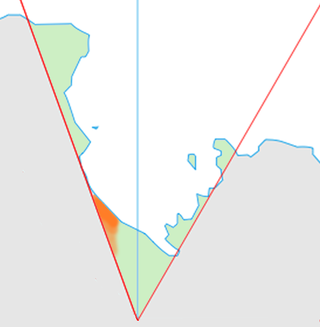
The Ross Embayment is a large region of Antarctica, comprising the Ross Ice Shelf and the Ross Sea, that lies between East and West Antarctica.

<span class="mw-page-title-main">Per Savio</span> Norwegian polar explorer

Per John Savio was a Norwegian polar explorer and dog sled driver. As a member of the Southern Cross expedition 1898–1900, Savio together with Ole Must were the first to overnight on the Antarctic continent. He was also part of the sled team who were the first persons to travel on the Ross Ice Shelf and reaching a new Farthest South record.

References

  1. 1 2 3 Woodford, J. 2000. The Wollemi Pine. Melbourne: Text Publishing. pp. 85-104
  2. U.S. Geological Survey Professional Paper. U.S. Government Printing Office. 1960.
  3. Barr, Iestyn D.; Spagnolo, Matteo; Rea, Brice R.; Bingham, Robert G.; Oien, Rachel P.; Adamson, Kathryn; Ely, Jeremy C.; Mullan, Donal J.; Pellitero, Ramón; Tomkins, Matt D. (21 September 2022). "60 million years of glaciation in the Transantarctic Mountains". Nature Communications. 13 (1): 5526. doi:10.1038/s41467-022-33310-z. ISSN   2041-1723. PMC   9492669 . PMID   36130952.
  4. 1 2 Winter, K.; Ross, N.; et al. (2018). "Topographic Steering of Enhanced Ice Flow at the Bottleneck Between East and West Antarctica". Geophysical Research Letters. 45 (10): 4899–907. Bibcode:2018GeoRL..45.4899W. doi: 10.1029/2018GL077504 .