The Beardmore Glacier in Antarctica is one of the largest valley glaciers in the world, being 200 km (125 mi) long and having a width of 40 km (25 mi). It descends about 2,200 m (7,200 ft) from the Antarctic Plateau to the Ross Ice Shelf and is bordered by the Commonwealth Range of the Queen Maud Mountains on the eastern side and the Queen Alexandra Range of the Central Transantarctic Mountains on the western. Its mouth is east of the Lennox-King Glacier. It is northwest of the Ramsey Glacier.
The Admiralty Mountains is a large group of high mountains and individually named ranges and ridges in northeastern Victoria Land, Antarctica. This mountain group is bounded by the sea, and by the Dennistoun Glacier, Ebbe Glacier, and Tucker Glacier.
The Dennistoun Glacier is a glacier, 50 nautical miles long, draining the northern slopes of Mount Black Prince, Mount Royalist and Mount Adam in the Admiralty Mountains of Victoria Land, Antarctica. It flows northwest between the Lyttelton Range and Dunedin Range, turning east on rounding the latter range to enter the sea south of Cape Scott.
The Everett Range is a rugged, mainly ice-covered range nearly 60 nautical miles long between Greenwell Glacier and Ebbe Glacier in northwest Victoria Land, Antarctica.
The Amundsen Glacier is a major Antarctic glacier, about 7 to 11 km wide and 150 km (80 nmi) long. It originates on the Antarctic Plateau where it drains the area to the south and west of Nilsen Plateau, then descends through the Queen Maud Mountains to enter the Ross Ice Shelf just west of the MacDonald Nunataks.
The Homerun Range is a northwest-trending range, 28 nautical miles long and 2 to 7 nautical miles wide, east of Everett Range at the heads of the Ebbe Glacier and Tucker Glacier in Victoria Land, Antarctica.
The Anare Mountains are a large group of mainly snow-covered peaks and ridges along the northern coast of Victoria Land, Antarctica. The group is bounded on the north and east by the Pacific Ocean, on the west by Lillie Glacier, and on the south by Ebbe Glacier and Dennistoun Glacier. They are north of the Concord Mountains and east of the Bowers Mountains.
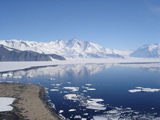
Lillie Glacier is a large glacier in Antarctica, about 100 nautical miles long and 10 nautical miles wide. It lies between the Bowers Mountains on the west and the Concord Mountains and Anare Mountains on the east, flowing to Ob' Bay on the coast and forming the Lillie Glacier Tongue.

Bowers Mountains is a group of north–south trending mountains in Antarctica, about 90 nautical miles long and 35 nautical miles wide, bounded by the coast on the north and by the Rennick Glacier, Canham Glacier, Black Glacier and Lillie Glacier in other quadrants. They are west of the Usarp Mountains, north of the Freyberg Mountains, northeast of the Concord Mountains, east of the Anare Mountains.
The Mirabito Range is a narrow, northwest-trending mountain range, 64 kilometres (40 mi) long and 6 kilometres (3.7 mi) wide that lies between the upper part of Lillie Glacier and the Greenwell Glacier in northern Victoria Land, Antarctica. The range is part of the Concord Mountains.
King Range is a mountain range, 22 km (14 mi) long and 8 km (5 mi) wide, in northwestern Victoria Land, Antarctica. The range is bounded on the west by Rawle Glacier and Leitch Massif, on the northwest by Black Glacier and on the NE and east by the head of Lillie Glacier. The range forms part of the Concord Mountains.
Tucker Glacier is a major valley glacier of Victoria Land, Antarctica, about 90 nautical miles long, flowing southeast between the Admiralty Mountains and the Victory Mountains to the Ross Sea. There is a snow saddle at the glacier's head, just west of Homerun Range, from which the Ebbe Glacier flows northwestward.
The Victory Mountains is a major group of mountains in Victoria Land, Antarctica, about 100 nautical miles long and 50 nautical miles wide, which is bounded primarily by Mariner and Tucker glaciers and the Ross Sea. They are north of the Mountaineer Range, east of the Freyberg Mountains and south of the Concord Mountains and the Admiralty Mountains. The division between the Victory Mountains and the Concord Mountains is not precise but apparently lies in the vicinity of Thomson Peak.
West Quartzite Range is a range, the western of two parallel quartzite ranges, situated at the east side of Houliston Glacier in the Concord Mountains, Antarctica. It was named by the Northern Party of the New Zealand Federated Mountain Clubs Antarctic Expedition (NZFMCAE), 1962–63, after the distinctive geological formation of the feature.
The Mountaineer Range is the range of mountains lying between the Mariner Glacier and Aviator Glacier in Victoria Land, Antarctica. It lies to the south of the Victory Mountains and northeast of the Southern Cross Mountains.
Explorers Range is a large mountain range in the Bowers Mountains of Victoria Land, Antarctica, extending from Mount Bruce in the north to Carryer Glacier and McLin Glacier in the south.
Rennick Glacier is broad glacier, nearly 200 nautical miles long, which is one of the largest in Antarctica. It rises on the polar plateau westward of Mesa Range and is 20 to 30 nautical miles wide, narrowing to 10 nautical miles near the coast. It takes its name from Rennick Bay where the glacier reaches the sea.
Posey Range is a mountain range in eastern Bowers Mountains, bounded by the Smithson Glacier, Graveson Glacier, Lillie Glacier and Champness Glacier.
The East Quartzite Range is a mountain range, 12 nautical miles long, forming a subordinate southwest unit of the King Range, in the Concord Mountains of Victoria Land, Antarctica. These mountains lie approximately 5 nautical miles east of the nearby West Quartzite Range. It was named by the Northern Party of the New Zealand Federated Mountain Clubs Antarctic Expedition (NZFMCAE), 1962–63, after the distinctive geological formation of the feature.
Salamander Range is a distinctive linear range between Canham Glacier and Black Glacier, in the Freyberg Mountains, Antarctica. The range was named by the Northern Party of New Zealand Geological Survey Antarctic Expedition (NZGSAE), 1963–64, from the nickname given to Lord Freyberg by Sir Winston Churchill, for the lizard that is untouched by fire.


