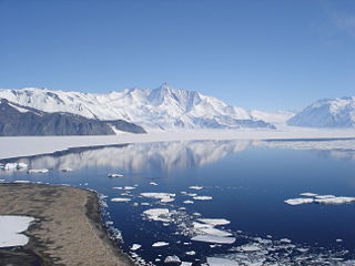
King Range ( 71°52′S165°03′E / 71.867°S 165.050°E ) is a mountain range, 22 km (14 mi) long and 8 km (5 mi) wide, in northwestern Victoria Land, Antarctica. The range is bounded on the west by Rawle Glacier and Leitch Massif, on the northwest by Black Glacier and on the NE and east by the head of Lillie Glacier. The range forms part of the Concord Mountains. [1]
The range was mapped by the USGS from surveys and U.S. Navy aerial photographs, 1960–63. Named by US-ACAN for Cdr. James P. King, USN, staff meteorological officer on Deep Freeze operations, 1962–64.

The Admiralty Mountains is a large group of high mountains and individually named ranges and ridges in northeastern Victoria Land, Antarctica. This mountain group is bounded by the sea, and by the Dennistoun Glacier, Ebbe Glacier, and Tucker Glacier.
The Everett Range is a rugged, mainly ice-covered range nearly 60 nautical miles long between Greenwell Glacier and Ebbe Glacier in northwest Victoria Land, Antarctica.
The Dunedin Range is a northwest-trending mountain range, 23 nautical miles long and 2 to 4 nautical miles wide. It is located 5 nautical miles east of Lyttelton Range in the Admiralty Mountains of Victoria Land, Antarctica.
The Homerun Range is a northwest-trending range, 28 nautical miles long and 2 to 7 nautical miles wide, east of Everett Range at the heads of the Ebbe Glacier and Tucker Glacier in Victoria Land, Antarctica.
The Anare Mountains are a large group of mainly snow-covered peaks and ridges along the northern coast of Victoria Land, Antarctica. The group is bounded on the north and east by the Pacific Ocean, on the west by Lillie Glacier, and on the south by Ebbe Glacier and Dennistoun Glacier.
Lillie Glacier is a large glacier in Antarctica, about 100 nautical miles long and 10 nautical miles wide. It lies between the Bowers Mountains on the west and the Concord Mountains and Anare Mountains on the east, flowing to Ob' Bay on the coast and forming the Lillie Glacier Tongue.
Concord Mountains is a group name applied to a complex system of ranges in northwest Victoria Land, Antarctica. They comprise the Everett Range, Mirabito Range, King Range, Leitch Massif, East Quartzite Range and West Quartzite Range.
The Mirabito Range is a narrow, northwest-trending mountain range, 64 kilometres (40 mi) long and 6 kilometres (3.7 mi) wide that lies between the upper part of Lillie Glacier and the Greenwell Glacier in northern Victoria Land, Antarctica. The range is part of the Concord Mountains.
Quam Heights is a mostly snow-covered heights, 15 nautical miles long and 4 nautical miles wide, rising over 1,000 metres (3,300 ft) and forming the coastline between the Barnett Glacier and Dennistoun Glacier in northern Victoria Land, Antarctica.
Zykov Glacier is a valley glacier about 25 nautical miles long in the Anare Mountains of Victoria Land, Antarctica. It flows northwest and reaches the coast between Cape Williams and Cooper Bluffs. It was photographed by the Soviet Antarctic Expedition (SovAE) in 1958 and named for student navigator Ye. Zykov, who died in Antarctica, Feb. 3, 1957.
Barnett Glacier is a large glacier in the Anare Mountains that flows east along the south side of Tapsell Foreland into Smith Inlet, northern Victoria Land, Antarctica.
The Freyberg Mountains are a group of mountains in Victoria Land, Antarctica, bounded by the Rennick Glacier, Bowers Mountains, Black Glacier, and Evans Névé.
Posey Range is a mountain range in eastern Bowers Mountains, bounded by the Smithson Glacier, Graveson Glacier, Lillie Glacier and Champness Glacier.
The East Quartzite Range is a mountain range, 12 nautical miles long, forming a subordinate southwest unit of the King Range, in the Concord Mountains of Victoria Land, Antarctica. These mountains lie approximately 5 nautical miles east of the nearby West Quartzite Range. It was named by the Northern Party of the New Zealand Federated Mountain Clubs Antarctic Expedition (NZFMCAE), 1962–63, after the distinctive geological formation of the feature.
Molar Massif is a large mountain massif immediately east of the Lanterman Range in the Bowers Mountains of Antarctica. It was mapped by the United States Geological Survey (USGS) from ground surveys and United States Navy air photos, 1960–1964. The descriptive name was applied by the United States Advisory Committee on Antarctic Names (US-ACAN) because, when viewed in plan, the outline of the massif resembles a molar tooth.
The Saxby Range is a broad mountain range, rising to 2,450 metres (8,040 ft), in the Victory Mountains of Victoria Land, Antarctica. It is bounded by Jutland Glacier, Tucker Glacier, Pearl Harbor Glacier, and Midway Glacier.
Salamander Range is a distinctive linear range between Canham Glacier and Black Glacier, in the Freyberg Mountains, Antarctica. The range was named by the Northern Party of New Zealand Geological Survey Antarctic Expedition (NZGSAE), 1963–64, from the nickname given to Lord Freyberg by Sir Winston Churchill, for the lizard that is untouched by fire.
Robinson Heights in Antarctica are the mainly ice-covered heights 2,170 metres (7,120 ft), elliptical in plan and 15 nautical miles long, which rise south of Anare Pass and form the northwest end of the Admiralty Mountains, Antarctica.
The Crown Hills are a group of peaks and hills forming the south-east part of the Lanterman Range in the Bowers Mountains of Victoria Land, Antarctica. Lying between Zenith Glacier and Gambone Peak, and including All Black Peak, they rise to a height of 2,000 metres (6,600 ft). The name was given by the New Zealand Antarctic Place-Names Committee (NZ-APC) in 1983, at the suggestion of geologist M.G. Laird, in association with nearby Coronet Peak.
The McGregor Range is a mountain range 13 nautical miles long in the south-central Admiralty Mountains, Antarctica. The range is circumscribed by the flow of the Tucker Glacier, Leander Glacier, Fitch Glacier and Man-o-War Glacier.
![]() This article incorporates public domain material from websites or documents of the United States Geological Survey .
This article incorporates public domain material from websites or documents of the United States Geological Survey .