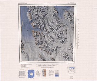
The Dennistoun Glacier is a glacier, 50 nautical miles long, draining the northern slopes of Mounts Black Prince, Royalist and Adam in the Admiralty Mountains of Victoria Land in Antarctica. It flows northwest between the Lyttelton Range and Dunedin Range, turning east on rounding the latter range to enter the sea south of Cape Scott. The coastal extremity of the glacier was charted in 1911–12 by the Northern Party, led by Victor Campbell, of the British Antarctic Expedition, 1910–13. The geographical feature lies situated on the Pennell Coast, a portion of Antarctica lying between Cape Williams and Cape Adare.

The Anare Mountains are a large group of mainly snow-covered peaks and ridges along the northern coast of Victoria Land, Antarctica. The group is bounded on the north and east by the Pacific Ocean, on the west by Lillie Glacier, and on the south by Robertson Glacier, Ebbe Glacier and Dennistoun Glacier. Kirkby Glacier, 20 miles (32 km) in length, drains the central Anare Mountains and flows northwest to the sea 3 miles (5 km) from Cape North, and just north of Arthurson Bluff, northern Victoria Land. The mountain range is situated on the Pennell Coast, a portion of Antarctica lying between Cape Williams and Cape Adare.
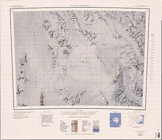
Bowers Mountains is a group of north–south trending mountains in Antarctica, about 145 km (90 mi) long and 56 km (35 mi) wide, bounded by the coast on the north and by the Rennick, Canham, Black and Lillie glaciers in other quadrants. The seaward end was first sighted in February 1911 from the Terra Nova, under Lt. Harry L.L. Pennell, RN, and was subsequently named "Bowers Hills" in honour of Henry Robertson Bowers who perished with Captain Robert Falcon Scott on their return from the South Pole in 1912. The mountain range is one of the most extensive topographical features within Victoria Land.
Explorers Range is a large mountain range in the Bowers Mountains of Victoria Land, Antarctica, extending from Mount Bruce in the north to Carryer Glacier and McLin Glacier in the south. Named by the New Zealand Antarctic Place-Names Committee (NZ-APC) for the northern party of New Zealand Geological Survey Antarctic Expedition (NZGSAE), 1963–64, whose members carried out a topographical and geological survey of the area. The names of several party members are assigned to features in and about this range. All of the geographical features listed below lie situated on the Pennell Coast, a portion of Antarctica lying between Cape Williams and Cape Adare.
Allegro Valley is a steep-sided, glacier-filled valley indenting the east side of Daniels Range just north of White Spur, in the Usarp Mountains, Antarctica. The northern party of the New Zealand Geological Survey Antarctic Expedition, 1963–64, experienced fine weather here after several days of unpleasant travel; therefore, the expedition members named it after John Milton's poem L'Allegro in antithesis to Penseroso Bluff, 14 miles (23 km) to the north. The valley is situated on the Pennell Coast, a portion of Antarctica lying between Cape Williams and Cape Adare.
Alvarez Glacier is a tributary glacier in the Explorers Range of the Bowers Mountains in Antarctica. It flows from the southwest side of Stanwix Peak into Rennick Glacier, to the north of Sheehan Glacier. It was mapped by United States Geological Survey from surveys and U.S. Navy air photos, 1960–62, and was named by the Advisory Committee on Antarctic Names for Lieutenant Commander Jose A. Alvarez, Argentine Navy, an International Geophysical Year Weather Central meteorologist at Little America V in 1957. The glacier is situated on the Pennell Coast, a portion of Antarctica lying between Cape Williams and Cape Adare.
Arruiz Glacier is a tributary glacier in the Explorers Range of the Bowers Mountains in Victoria Land, Antarctica. It flows west-northwest from Stanwix Peak and enters Rennick Glacier north of Frolov Ridge. It was mapped by the United States Geological Survey from surveys and from U.S. Navy air photos, 1960–62, and named by the Advisory Committee on Antarctic Names for Lieutenant Alberto J. Arruiz, Argentine IGY observer, a Weather Central meteorologist at Little America V in 1958. The glacier lies on the Pennell Coast, a portion of Antarctica lying between Cape Williams and Cape Adare.
Barnett Glacier is a large glacier in the Anare Mountains that flows east along the south side of Tapsell Foreland into Smith Inlet, northern Victoria Land, Antarctica. It was mapped by the United States Geological Survey (USGS) from surveys and from U.S. Navy air photos, 1960–63, and named by the Advisory Committee on Antarctic Names after Donald C. Barnett, USGS topographic engineer, a member of USGS Topo East and West, 1962–63, in which the expedition extended geodetic control from the area of Cape Hallett to the Wilson Hills and from the foot of Beardmore Glacier through the Horlick Mountains. The glacier lies on the Pennell Coast, a portion of Antarctica lying between Cape Williams and Cape Adare.
Canham Glacier is a tributary glacier about 30 nautical miles (60 km) long which drains the northwest part of Evans Neve in Antarctica. The glacier drains northwest between the Alamein Range and the Salamander Range of the Freyberg Mountains and enters the Rennick Glacier westward of Bowers Peak, Victoria Land. The geographical feature was first mapped by the United States Geological Survey from surveys and from U.S. Navy air photos, 1960–62, and named by the Advisory Committee on Antarctic Names for Lieutenant Commander David W. Canham, Jr., officer in charge of the winter party at the U.S. Naval Air Facility, McMurdo Sound, 1956. The glacier lies situated on the Pennell Coast, a portion of Antarctica lying between Cape Williams and Cape Adare.
Carryer Glacier is a heavily crevassed tributary glacier, 12 nautical miles (22 km) long, which drains westward from the central part of the Bowers Mountains and enters Rennick Glacier between Mount Soza and Mount Gow, Victoria Land, Antarctica. The glacier was named by the northern party of New Zealand Geological Survey Antarctic Expedition, 1963–64, for S.J. Carryer, former geologist with this party. The glacier lies situated on the Pennell Coast, a portion of Antarctica lying between Cape Williams and Cape Adare.
The Caudal Hills are a group of hills situated within Victoria Land, Antarctica the hills lie between the Sequence Hills and the Lichen Hills on the western margin of upper Rennick Glacier. A series of spurs "tail" out to the north, hence the name "Caudal". They were so named by the northern party of New Zealand Geological Survey Antarctic Expedition, 1962–63. The Caudal Hills lies situated on the Pennell Coast, a portion of Antarctica lying between Cape Williams and Cape Adare.

Gressitt Glacier is a broad glacier, about 45 nautical miles (80 km) long, draining the area between the Daniels Range and the Emlen Peaks in the Usarp Mountains of Victoria Land, Antarctica, and flowing northeast to enter the Rennick Glacier just north of the Morozumi Range. This geographical feature was first mapped by the United States Geological Survey from surveys and U.S. Navy air photos, 1960–63, and was so named by the Advisory Committee on Antarctic Names for biologist J. Linsley Gressitt, Program Director, who made biological studies, particularly in the Ross Sea area, during six austral summers, 1959–60 to 1965–66. The glacier lies situated on the Pennell Coast, a portion of Antarctica lying between Cape Williams and Cape Adare.
Mount Gow is a mountain, measuring in at 1,770 metres (5,800 ft) of height, on the east side of Rennick Glacier in the Bowers Mountains of Victoria Land, Antarctica. It marks the west end of the rugged heights between the mouths of Carryer Glacier and Sledgers Glacier where these two tributaries enter the nearby Rennick Glacier. This topographical feature was first mapped by the United States Geological Survey from surveys and U.S. Navy air photos, 1960–62, and was named by the Advisory Committee on Antarctic Names for Anthony J. Gow, a veteran Antarctic glaciologist who conducted his scientific research at the Byrd Station, South Pole Station, and McMurdo Station during nearly every Summer season ranging from 1959 to 1969. The mountain lies situated on the Pennell Coast, a portion of Antarctica lying between Cape Williams and Cape Adare.
Edlin Névé is a névé at the south side of Mount Sturm in the Bowers Mountains of Victoria Land, Antarctica. Several glaciers, including the Carryer, Irwin, McLin and Graveson, are nourished by this névé. it was named by the New Zealand Geological Survey Antarctic Expedition, 1967–68, for George Robert Edlin 1921-1992, who served as the first postmaster at Scott Base and assisted in the field during this expedition. This glaciological feature lies situated on the Pennell Coast, a portion of Antarctica lying between Cape Williams and Cape Adare.
Evans Névé is a large névé which nourishes Tucker Glacier, Mariner Glacier, Aviator Glacier, Rennick Glacier and Lillie Glacier in Victoria Land, Antarctica. The névé was named in honor for Edgar Evans of the ill-fated British Antarctic Expedition, 1910–13, by the Northern Party of the New Zealand Geological Survey Antarctic Expedition, 1963–64. Evans, along with Edward Adrian Wilson, Lawrence Oates and Henry Robertson Bowers, accompanied Captain Robert F. Scott to the Geographic South Pole, January 17, 1912. All five perished on the return journey after failing to beat Norwegian explorer Roald Amundsen to the 90th parallel. This glaciological feature lies situated on the Pennell Coast, a portion of Antarctica lying between Cape Williams and Cape Adare.
Field Névé is a large névé between the Homerun Range and the Findlay Range in the Admiralty Mountains of Victoria Land, Antarctica. The feature lies between the upper reaches of Ebbe Glacier, which flows northwest, and Tucker Glacier, which flows southeast. It was named by the New Zealand Antarctic Place-Names Committee after Bradley Field, a geologist with the New Zealand Geological Survey, and a member of a New Zealand Antarctic Research Program geological party to northern Victoria Land, 1981–82. This glaciological feature lies situated on the Pennell Coast, a portion of Antarctica lying between Cape Williams and Cape Adare.
Graveson Glacier is a broad north-flowing tributary to the Lillie Glacier, draining that portion of the Bowers Mountains between the Posey Range and the southern part of Explorers Range, Victoria Land, Antarctica. The geographical feature is fed by several lesser tributaries and enters Lillie Glacier via Flensing Icefall. The glacier was so named by the northern party of the New Zealand Geological Survey Antarctic Expedition, 1963–64, for F. Graveson, a mining engineer who wintered at Scott Base in 1963 and was field assistant on this expedition. The glacier lies situated on the Pennell Coast, a portion of Antarctica lying between Cape Williams and Cape Adare.
Head Peak is a peak 3.5 nautical miles (6 km) east of Le Couteur Peak, situated on a projecting ridge of Millen Range in the névé area of Pearl Harbor Glacier, Victoria Land, Antarctica. This topographical feature was so named by the Southern Party of the New Zealand Federated Mountain Clubs Antarctic Expedition (NZFMCAE), 1962–63, due to its likeness to a head and to its position at the head of the adjacent Pearl Harbor Glacier. The peak lies situated on the Pennell Coast, a portion of Antarctica lying between Cape Williams and Cape Adare.
Hunter Glacier is a tributary glacier, 7 nautical miles (13 km) long, draining westward from the central Lanterman Range in the Bowers Mountains of Victoria Land, Antarctica and entering Rennick Glacier at Mount Lugering. It was first mapped by the United States Geological Survey from surveys and U.S. Navy air photos, 1960–62, and was so named by the Advisory Committee on Antarctic Names for Lieutenant Commander William G. Hunter, executive and operations officer with the McMurdo Station winter party in 1964. This glacier lies situated on the Pennell Coast, a portion of Antarctica lying between Cape Williams and Cape Adare.
Husky Pass is a pass between the Lanterman Range and Molar Massif in the Bowers Mountains of Victoria Land, Antarctica, located at the head of Sledgers Glacier and an unnamed tributary, leading to Leap Year Glacier. This mountain pass was so named by the New Zealand Geological Survey Antarctic Expedition, 1963–64, for the great efforts made here by dog teams in hauling out of the Rennick Glacier basin into that of Lillie Glacier. The pass lies situated on the Pennell Coast, a portion of Antarctica lying between Cape Williams and Cape Adare.
